Displaying 28 - 54 of 845

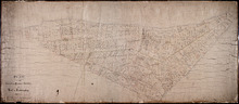
Map of Prince Edward Island
Description: Map of Prince Edward Island showing school districts(?). The map shows bodies of water and town and cities.
Province: Prince Edward Island
Type: cadastral maps, thematic maps
Date Created: 1971-02-05
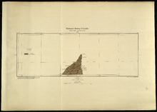
Prince Edward Island
Description: Prince Edward Island. Geological Survey of Canada. The map shows the North Point of the island, roads, railways, post offices, towns, and cities.
Province: Prince Edward Island
Type: geological maps
Date Created: 1884
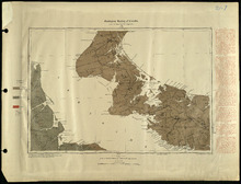
Prince Edward Island
Description: Prince Edward Island. Geological Survey of Canada. The map shows Prince county, roads, bodies of water, cities and towns.
Province: Prince Edward Island
Type: geological maps
Date Created: 1884
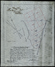
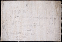
Plan of Webber Creek: being supplementary to "Plan of Richmond Bay from Curtain Island to…
Description: Plan of Webber Creek being supplementary to "Plan of Richmond Bay from Curtain Island to Lockes Shore" showing additional plots Nos. 478B, 478C, 478D, and 478E for Oyster Culture. The map… more
Province: Prince Edward Island
Type: plans
Date Created: 1913-10-08
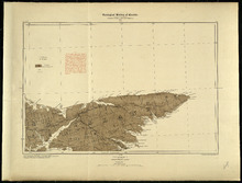
Prince Edward Island
Description: Prince Edward Island. Geological Survey of Canada. The map shows Kings county roads, cities and towns.
Province: Prince Edward Island
Type: geological maps
Date Created: 1884
Plan of the Cunard and Palmer Estates in Lot or Township No.1.
Description: Plan of Lot 1 (No.1). Cunard and Palmer Estates. Drawn by Owen Curtis. Shows names of residents, acreage, and a few land conveyance references, and roads.
Province: Prince Edward Island
Type: cadastral maps
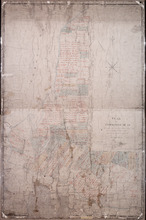
Plan of Township No 15: Taken from the survey of William Cutis (1826) wit alterations and…
Description: Plan of Lot 15 (No.42) taken from the survey of William Curtis (1826) with alterations and corrections from surveys made in 1849 and 1851 by Geo. Wright. Color code shows Crown Lands and lands… more
Province: Prince Edward Island
Type: cadastral maps
Date Created: 1851

Plan of Township No. 48: compiled during the year 1915 from plans on file in the Land Office and…
Description: Plan of Lot 48 compiled during the year 1915 from plans on file in the Land Office and Registry Office and from the chart of Charlottetown Harbour supplemented by the descriptions in the leases and… more
Province: Prince Edward Island
Type: cadastral maps
Date Created: 1915

Plan of Township No. 63: compiled from the proprietors' plans, descriptions in leases and…
Description: Plan of Lot 63 compiled from the proprietors' plans, descriptions in leases and registered deeds, and from Meacham's Atlas, with additions and corrections from surveys made at various times… more
Province: Prince Edward Island
Type: cadastral maps
Date Created: 1921-02
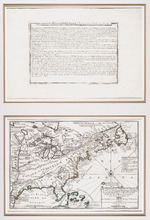
Le Canada, ou Nouvelle France, la Floride, la Virginie, Pensilvanie, Caroline, Nouvelle Angleterre…
Description: This item is a rectangular copper engraving of a map of North America, from the Mississipi to the Atlantic, with separate descriptive text from the "Atlas Curieux" displayed above. A box at… more
Type: topographic maps
Date Created: 1702
Carte Nouvelle contenant la Partie d'Amerique La Plus Septentrionale, ou sont exactement…
Description: The map shows the Gulf of St. Lawrence, the northeast Atlantic and the provinces of New Brunswick, Newfoundland, Nova Scotia and Prince Edward Island, as well as part of Quebec. Sable Island,… more
Province: New Brunswick, Newfoundland, Nova Scotia, Prince Edward Island, Quebec
Type: topographic maps
Date Created: 1666
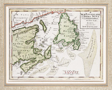
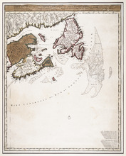
A NewFoundland, od. Terra Nova S. Laurentii Bay, die Fisch-Bank, Acadia, nebst einem Theil New…
Description: The map shows the Gulf of St. Lawrence, part of the northeast Atlantic and the provinces of New Brunswick, Newfoundland, Nova Scotia and Prince Edward Island, as well as part of Quebec. Sable Island… more
Province: New Brunswick, Newfoundland, Nova Scotia, Prince Edward Island, Quebec
Type: topographic maps
Date Created: 1720
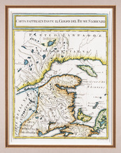
Carta Rappresentante il Golfo del Fiume S. Lorenzo
Description: The map shows the St. Lawrence River/Gulf of St. Lawrence region as far west as the Saguenay River and as far east as Cape Breton. It shows New Brunswick, Prince Edward Island, and parts of Nova… more
Province: New Brunswick, Nova Scotia, Prince Edward Island, Quebec
Type: topographic maps
Date Created: 1765 (year approximate)
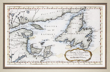
Carte du Golphe de St. Laurent et Pays Voisins Pour Servir a l'Histoire Generale des Voyages.
Description: The map shows the Gulf of St. Lawrence, New Brunswick, Newfoundland, Prince Edward Island, and parts of Nova Scotia and Quebec. It shows Anticosti Island and the Magdelan Islands. The map uses labels… more, Provenance: Purchased by Mr. Macnutt in London at the Map House in 1982. [Information from the back of the item], Exhibition & Catalogue: 1. The James W. Macnutt Collection of Maps of the Gulf of St. Lawrence with Particular Emphasis on Prince Edward Island, Confederation Centre Art Gallery and Museum, June… more
Province: New Brunswick, Newfoundland, Nova Scotia, Prince Edward Island, Quebec
Type: topographic maps
The British Colonies in North America
Description: The map shows New Brunswick, Nova Scotia, Prince Edward Island and parts of Ontario, Quebec and the United States. Newfoundland is shown at the same scale in an inset in the upper left corner. Rivers… more
Publisher: James S. Virtue
Province: New Brunswick, Newfoundland, Nova Scotia, Prince Edward Island, Ontario, Quebec
Type: topographic maps
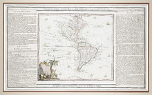
L'Amérique Dressée pour l'étude de la Géographie,: revue et augmentée par Mr. Brion,…
Description: This is a map of the Americas with the northwestern part of North America left undefined. It shows more large lakes to the west of the Great Lakes and a river route to the Pacific, which was believed… more
Type: chorographic maps
Date Created: 1786
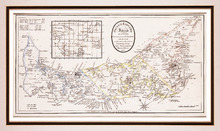
Prince Edward Island, divided into Counties & Parishes, with the Lots, as Granted by Government…
Description: Framed map of the province of Prince Edward Island. As the title indicates, the map shows Prince Edward Island divided into counties (shown in blue, yellow and pink), parishes and the Holland lots.… more
Publisher: Ashby, H.
Province: Prince Edward Island
Type: topographic maps
Date Created: 1798
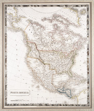
North America: By Sidney Hall.
Description: Framed map of North America. The map shows North America and parts of South America, Greenland and Russia (including the territory that is now Alaska). Part of present-day British Columbia, including… more
Publisher: Longman, Rees, Orme, Brown & Green
Type: chorographic maps
Date Created: 1829-08-01
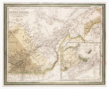
Canada East, Formerly Lower Canada. [with] Nova Scotia, New Brunswick &c.: Published by S.…
Description: The map shows part of Quebec (Canada East) and adjoining parts of New Brunswick and the United States. An inset map shows New Brunswick, Nova Scotia and Prince Edward Island. Colour is used to… more
Publisher: S. Augustus Mitchell
Province: New Brunswick, Nova Scotia, Prince Edward Island, Quebec
Type: topographic maps
Date Created: 1846
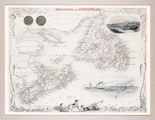
Nova Scotia and Newfoundland
Description: The map shows Newfoundland, Nova Scotia and Prince Edward Island and parts of New Brunswick and Quebec. Newfoundland, Nova Scotia, P.E.I., Anticosti Island and the Magdalen Islands are mapped in… more
Publisher: J. & F. Tallis
Province: Newfoundland, Nova Scotia, Prince Edward Island
Type: topographic maps
Date Created: 1851
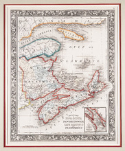
County Map of Nova Scotia New Brunswick Cape Breton Id. and Pr. Edward's Id.
Description: The map shows New Brunswick, Nova Scotia and Prince Edward Island and parts of Quebec and Maine. An inset shows the "City and Harbor of Halifax." Bright colours are used to outline… more
Publisher: S. A. Mitchell Jr.
Province: New Brunswick, Nova Scotia, Prince Edward Island
Type: topographic maps
Date Created: 1860
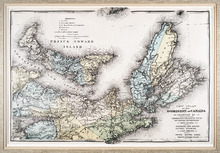
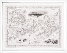
New Atlas of the Dominion of Canada — Counties of Cumberland, Colchester, Pictou, Antigonish,…
Description: The map shows Prince Edward Island and part of Nova Scotia, including all of Cape Breton. The provinces' counties are coloured and labelled in uppercase lettering. A legend explains the symbols… more
Publisher: Meacham Publishing Co.
Province: Nova Scotia, Prince Edward Island
Type: topographic maps
Date Created: 1875 (year approximate)

Geological Map of Canada and Newfoundland: Derive from the Results of The Canadian Geological…
Description: Framed map of Canada and Newfoundland. The map is has colours for different land marks, and a table that explains it all. Shown are bodies of water such as rivers, islands, roads, towns, and cities.
Province: Newfoundland, New Brunswick, Prince Edward Island, Nova Scotia, Quebec
Type: geological maps
Date Created: 1866 (year uncertain)
Plan of Cascumpec Point As sold by Public Auction in June 1871
Description: Plan of Cascumpec Point, as sold by public auction, June, 1871. The map shows lots, residents, bodies of water such as bays, cities and towns, and roads.
Province: Prince Edward Island
Type: cadastral maps
Date Created: 1871-08

Plan of that portion of the town of Summerside laid off on the front of the farm by Mr. Jesse Green.
Description: Plan of that portion of the town of Summerside laid off on the front of the farm by Mr. Jesse Green. The map shows lots, residents, towns, cities, roads, and bodies of water.
Province: Prince Edward Island
Type: cadastral maps
Date Created: 1868-11-25
A Plan of the Property of Capt. Simon and Alexander Cheverie: in Souris East
Description: A plan of the property of Capt. Simon and Alexander Cheverie in Souris East. The map shows lots, acreage, roads/streets, and buildings.
Province: Prince Edward Island
Type: cadastral maps
Date Created: 1879-06-18

Common Lot No 21 as divided into Building Lots
Description: Plan of Common Lot No.21. Charlottetown as divided into building lots. (No.380) The map shows lots, acreage and roads/streets.
Province: Prince Edward Island
Type: cadastral maps
Date Created: 1872-08