Displaying 1 - 19 of 19
Stanhope Shore Rd.
Description: The map shows the Stanhope Shore Road with the names of residents, their road frontage measurements and dollar amounts for each.
Province: Prince Edward Island
Type: cadastral maps
Date Created: 1954
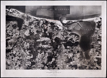
Prince Edward Island National Park: Covehead - Tracadie Section 1937
Description: Prince Edward Island National Park. Covehead - Tracadie section. Lots 34 and 35. Aerial photograph. Department of Mines and Resources, Mines and Geology Branch. Bureau of Geology and Topography. The… more
Province: Prince Edward Island
Type: cadastral maps, aerial photographs
Date Created: 1937
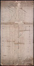
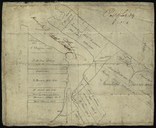
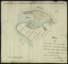
A Plan of Township No. 34, The Property of Sir Graham Montgomery & Brothers Situate in Queens…
Description: Plan of Lot 34 (No.89). The property of Sir Graham Montgomery & Brothers. Shows names of residents and acreage, bodies of water such as rivers, and bays, roads, and a nautical compass.
Province: Prince Edward Island
Type: cadastral maps
Date Created: 1850-03-19
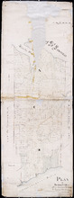
Plan of Township No,, 34 in Queens County in P. E. Island. The Property of Messrs,, Montgomeries,…
Description: Plan of Lot 34. Property of Messrs. Montgomery. Shows names of residents and acreage. Plan handed in to Registry Office by Aemeas McDonald. The map also shows bodies of water, bays, rivers, ponds,… more
Province: Prince Edward Island
Type: cadastral maps
Date Created: 1853-08
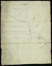
Royalty of Charlotettown
Description: Plan showing the line dividing Lots 33 and 34. (No.10). The map shows lots, residents, roads, and bodies of water.
Province: Prince Edward Island
Type: cadastral maps

Plan Shewing the position of the Northern points of Commencement of the Lines dividing Lots 33 and…
Description: The map shows northern portions of Lots 24, 33, 34 and 35 along the north shore of Prince Edward Island. It shows the northern-most sections of three boundary lines: the line dividing Lots 24 and 33… more
Province: Prince Edward Island
Type: chorographic maps
Date Created: 1835-05-07

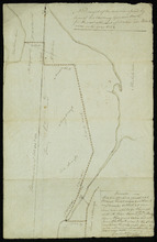
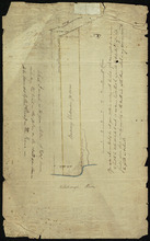
Lot 34: Southern portion
Description: Part of Lot 34 (No.7). North side of Hillsborough River.
Province: Prince Edward Island
Type: cadastral maps

Plan of Lot or Township No. 34
Description: Plan of Lot 34 (No. 90). Montgomery Estate. Working plan. The map shows Lot 34 divided into parcels of land with the names of residents and their acreage amounts handwritten in black ink. Land… more
Province: Prince Edward Island
Type: cadastral maps
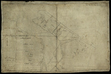
Part of Lot 34
Description: Plan of part of Lot 34 (No.5). Shows properties of John Millar, L. Brown, Neil Shaw, Murdock McCloud, and John Crabtree. The map shows the northwestern portion of Lot 34 divided into parcels of land… more
Province: Prince Edward Island
Type: cadastral maps
Part of Lot 34
Description: Plan of part of Lot 34 (No.3). Area around Covehead Bay. The map shows the northwestern portion of Lot 34, divided into parcels of land with the names of residents and/or proprietors and their… more
Province: Prince Edward Island
Type: cadastral maps
Part of Lot 34
Description: Plan of part of Lot 34 (No.6). Area around Covehead Bay. The map shows the northwestern portion of Lot 34 divided into parcels of land with the names of residents and/or proprietors and their acreage… more
Province: Prince Edward Island
Type: cadastral maps
A Draugth of the new road opened by order of his Excellency Governor Smith, for the west settlement…
Description: Plan of part of Lot 34 (No.41). This plan shows a new road in the Covehead area in the northwest corner of Lot 34. It describes the land surrounding the road with labels noting swamp or hardwood… more
Province: Prince Edward Island
Type: engineering maps
Date Created: 1824
Plan of Mrs. Vickersons Land
Description: Plan of part of Lot 34 (No. 4). 74 acres of land. The map shows Barbarey Vickerson's 74-acre parcel of land on the north side of the Hillsborough River in Lot 34. The plan shows roads, including… more
Province: Prince Edward Island
Type: cadastral maps
Date Created: 1809-10-12
Plan of A tract of Land the property the Messrs. Macmillans & Peter Higgins on Township No. 34…
Description: Plan of part of Lot 34 (No. 182). The map shows a parcel of land 111 acres in size belonging to Angus MacMillan, Peter Higgins and Alexander MacMillan near the entrance to Covehead Harbour and what… more
Province: Prince Edward Island
Type: cadastral maps
Date Created: 1854
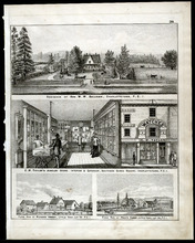
Property Sketches - Page 38
Description: Property sketches of the Residence of Hon. W. W. Sullivan, Charlottetown, P.E.I.; E.W. Taylor' Jewelry Store - interior and exterior, South Side Queen Square, Charlottetown, P.E.I.; The farms of… more
Publisher: J. H. Meacham & company
Province: Prince Edward Island
Type: image
Date Issued (Source): 1880
Rural Directory - Lots 31 - 34, Queens County
Description: A directory listing of residents of lots 31, 32, 33, and 34.
Publisher: Cummins Map Co.
Province: Prince Edward Island
Type: text
Date Issued (Source): 1927
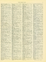
Rural Directory - Lots 33 and 34, Queens County
Description: A directory listing of residents of lots 33 and 34.
Publisher: Cummins Map Co.
Province: Prince Edward Island
Type: text
Date Issued (Source): 1927
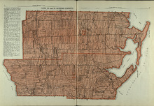
Lots 33 and 34 : Queens County
Description: The map shows lots 33 and 34 in Queens county. Shown are the Gulf of St. Lawrence, Cove Head and Rustico Bay, Hillsborough River, landowners, acreage, roads, railroads, Royalty Junction and Suffolk… more
Publisher: Cummins Map Co.
Province: Prince Edward Island
Type: cadastral maps
Date Issued (Source): 1927
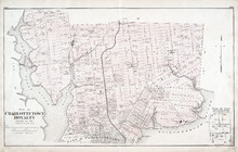
Plan of Charlottetown Royalty: Queens Co., P.E.I.
Description: The map shows the city of Charlottetown and a plan for lots. Shown are rivers, creeks, roads, railroad and stations, landowners and acreage, mills, park, bridge, college, farms, asylums, and a… more
Publisher: J. H. Meacham & company
Province: Prince Edward Island
Type: cadastral maps
Date Issued (Source): 1880