Displaying 1 - 11 of 11
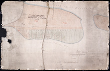
Plan "A" Part of Township No. 24: as divided amongst the children of the late Alfred…
Description: Plan "A" part of Lot 24 as divided amongst the children of the late Alfred Winsloe (No.64). Shows names of residents and acreage, bodies of water such as rivers, creeks, roads, and a… more
Province: Prince Edward Island
Type: cadastral maps
Date Created: 1872-06-11
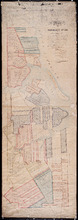
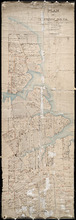
Plan of Lot 24 (No.66): Part of the estate of John Hodges Winsloe
Description: Plan of Lot 24 (No.66). Part of the estate of John Hodges Winsloe. Shows names of residents, acreage, and a few land conveyance references, bodies of water such as Gulf of St. Laurence, rivers, roads… more
Province: Prince Edward Island
Type: cadastral maps
Date Created: 1847
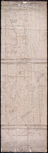
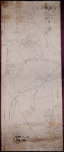
This is the Plan of Township No. 24 in Prince Edward Island
Description: Plan of Lot 24 showing the division of the Winsloe Estate. Shows names of residents and acreage, bodies of water such as gulfs, bays, creeks, rivers, sand hills, Rustico or Peter's Island and… more
Province: Prince Edward Island
Type: cadastral maps
Date Created: 1863-03-13
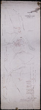
Plan of Township No. 24 in Prince Edward Island
Description: Plan of Lot 24. Smith Estate. Mainly outline but shows a few residents and acreage, bodies of water such as rivers, gulfs, bays and creeks, roads, sand hills, and Rustico or Peter's Island. more
Province: Prince Edward Island
Type: cadastral maps
Plan of the property of Mrs W.L. Smith : Situate on Township No. 24 in Prince Edward Island, Mrs L…
Description: Plan of the property of Mrs W.S. Smith. Situated on Lot 24. The maps shows bodies of water such as rivers and creeks, Rustico Island, roads, and a nautical compass.
Province: Prince Edward Island
Type: cadastral maps

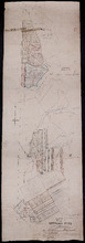
Plan Shewing the position of the Northern points of Commencement of the Lines dividing Lots 33 and…
Description: The map shows northern portions of Lots 24, 33, 34 and 35 along the north shore of Prince Edward Island. It shows the northern-most sections of three boundary lines: the line dividing Lots 24 and 33… more
Province: Prince Edward Island
Type: chorographic maps
Date Created: 1835-05-07
Plan of Township No. 24: Copied from plan furnished by Proprietors with numerous corrections from…
Description: Working plan of Lot 24 (No.67). Winsloe Estate. Surveyed by H.J Cundall and others; copied by Thos. MacKinlay.
Province: Prince Edward Island
Type: cadastral maps
Date Created: 1886-02
Plan Shewing the situation of the respective Fishing Establishments, Fronting Harris or Rustico Bay…
Description: Plan of part of Lot 24. Shows situation of the fishing establishments fronting Harris or Rustico Bay. From actual survey. The map shows the Harbours Mouth and Robinsons Island.
Province: Prince Edward Island
Type: cadastral maps
Date Created: 1869-09-02
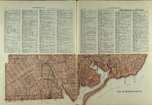
Lot 24: Queens County
Description: The map shows lot 24 in Queens county. Shown are the Gulf of St. Lawrence, Rustico Bay and Harbour, river, cape, roads, landowners, and acreage.
Publisher: Cummins Map Co.
Province: Prince Edward Island
Type: cadastral maps
Date Issued (Source): 1927
Rural Directory - Lots 24, 29, and 30, Queens County
Description: A directory listing of residents of lots 24, 29, and 30
Publisher: Cummins Map Co.
Province: Prince Edward Island
Type: text
Date Issued (Source): 1927
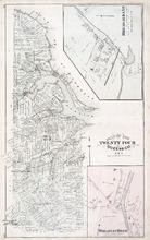
Plan of Lot Twenty Four: Queens Co., P.E.I.
Description: The map shows lot 24 in Queens county. Shown are rivers, gulfs, capes harbours, wharfs, lighthouses, fishing stages and holes, seaside hotels and bath houses, churches, crosses, post offices, roads,… more
Publisher: J. H. Meacham & company
Province: Prince Edward Island
Type: cadastral maps
Date Issued (Source): 1880