Displaying 784 - 810 of 992
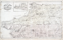
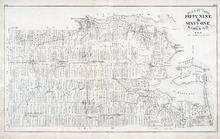
Plan of Lots Fifty Seven & Fifty Eight: Queens Co., P.E.I.
Description: The map shows lots 57 & 58 in Queens county. Includes an inset map of Prim Island / Point Prim. Shown are roads, landowners and acreage, crosses, rivers, ponds, creeks, bays, coves, sand, wharfs… more
Publisher: J. H. Meacham & company
Province: Prince Edward Island
Type: cadastral maps
Date Issued (Source): 1880
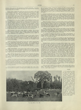
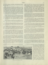
New Brunswick - 2
Description: Text provides information of Farming and Forestry in New Brunswick
Publisher: Cummins Map Co.
Province: New Brunswick
Type: text
Date Issued (Source): 1927
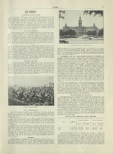
Quebec - 1
Description: Text provides information of history, population, and farming industry of Quebec
Publisher: Cummins Map Co.
Province: Quebec
Type: text
Date Issued (Source): 1927
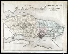
Georgetown Royalty and Reserve Land: Kings Co., P.E.I.
Description: The map shows Georgetown Royalty and Reserve Land in Kings county. Shown are rivers, roads, railroads and stations, landowners and acreage, beaches, Georgetown commons, square, market, court house,… more
Publisher: J. H. Meacham & company
Province: Prince Edward Island
Type: cadastral maps
Date Issued (Source): 1880
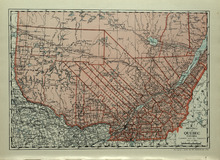
Province of Quebec, Canada
Description: The map shows the province of Quebec in Canada. Shown are Ontario, New York, Maine, towns, cities, raods, railroads, and St. Lawrence River.
Publisher: Cummins Map Co.
Province: Quebec
Type: cadastral maps
Date Issued (Source): 1927
Plan of Lots 59 & 61: Kings Co., P.E.I.
Description: The map shows lots 59 & 61 in Kings county. Shown are roads, landowners and acreage, crosses, rivers, ponds, creeks, bays, coves, sand, wharfs, mills, post offices, churches, schools, light… more
Publisher: J. H. Meacham & company
Province: Prince Edward Island
Type: cadastral maps
Date Issued (Source): 1880
Quebec - 2
Description: Text provides information of the farming industry of Quebec
Publisher: Cummins Map Co.
Province: Quebec
Type: text
Date Issued (Source): 1927
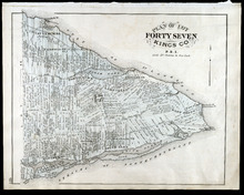
Plan of Lot Forty Seven: Kings Co., P.E.I.
Description: The map shows Lot 47 in Kings county. Shown are a gulf, straits, rivers, lakes, swamp, sand, fishing huts, mills, post offices, churches, creeks, light house, and pond. Compass.
Publisher: J. H. Meacham & company
Province: Prince Edward Island
Type: cadastral maps
Date Issued (Source): 1880
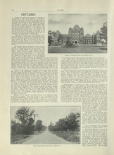
Ontario - 1
Description: Text provides information on the history and farming industries of Ontario
Publisher: Cummins Map Co.
Province: Ontario
Type: text
Date Issued (Source): 1927
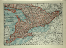
Province of Ontario, Canada
Description: The map shows the Province of Ontario, Canada. Shown are Georgian Bay, Lake Ontario, Erie, and Huron, Michigan, New York, roads, towns and cities.
Publisher: Cummins Map Co.
Province: Ontario
Type: cadastral maps
Date Issued (Source): 1927
Plan of Lot Sixty & Sixty Two: Queens Co., P.E.I.
Description: The map shows lots 60 & 62 in Queens county. Shown are roads, landowners and acreage, rivers, straits, ponds, bays, creeks, sand, post offices, mills, churches, and school houses. Graphic compass.
Publisher: J. H. Meacham & company
Province: Prince Edward Island
Type: cadastral maps
Date Issued (Source): 1880

Ontario - 2
Description: Text provides information of the farming and other industries of Ontario
Publisher: Cummins Map Co.
Province: Ontario
Type: text
Date Issued (Source): 1927
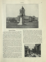
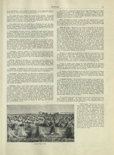
Manitoba - 1
Description: Text provides information of history, climate, and farming in Manitoba.
Publisher: Cummins Map Co.
Province: Manitoba
Type: text
Date Issued (Source): 1927
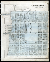
Georgetown: Kings Co., P.E.I.
Description: The map shows Georgetown in Kings county. Shown are wharfs, harbour, roads and streets, railroads and stations, landowners, houses, court house, scholl house, drill shed, Georgetown square, churches… more
Publisher: J. H. Meacham & company
Province: Prince Edward Island
Type: cadastral maps
Date Issued (Source): 1880
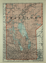
Province of Manitoba, Canada
Description: The map shows the province of Manitoba, Canada. Shown are the lakes, rivers and other bodies of water, and railroads.
Publisher: Cummins Map Co.
Province: Manitoba, Saskatchewan, Ontario
Type: cadastral maps
Date Issued (Source): 1927
Plan of Lots 63 & 64: Kings Co., P.E.I.
Description: The map shows Lots 63 & 64 in Kings county. Shown are roads, landowners and acreage, crosses, rivers, straits, ponds, gulfs, marshes, coves, wharfs, post offices, mills, churches, factories, and… more
Publisher: J. H. Meacham & company
Province: Prince Edward Island
Type: cadastral maps
Date Issued (Source): 1880
Manitoba - 2
Description: Text provides information of the landscape, industries, and government of Manitoba
Publisher: Cummins Map Co.
Province: Manitoba
Type: text
Date Issued (Source): 1927
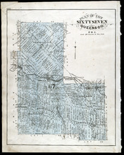
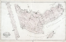
Plan of Lot Sixty Seven: Queens Co., P.E.I.
Description: The map shows Lot 67 in Queens county. Shown are roads, landowners and acreage, railroads and stations, post offices, church, and school houses. Compass.
Publisher: J. H. Meacham & company
Province: Prince Edward Island
Type: cadastral maps
Date Issued (Source): 1880
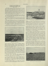
Saskatchewan - 1
Description: Text provides information of the history, government, and landscape of Saskatchewan
Publisher: Cummins Map Co.
Province: Saskatchewan
Type: text
Date Issued (Source): 1927
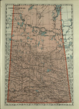
Province of Saskatchewan, Canada
Description: The map shows the province of Saskatchewan, Canada. Shown are rivers, lakes, and other bodies of water, roads, and railroads.
Publisher: Cummins Map Co.
Province: Saskatchewan, Alberta, Mantitoba
Type: cadastral maps
Date Issued (Source): 1927
Plan of Lot 65 : Queens Co., P.E.I.
Description: The map shows Lot 65 in Queens county. Shown are roads, landowners and acreage, creeks, rivers, straits, marshes, brooks, coves, sand, reef, fishing stage, wharfs, post offices, mills, churches,… more
Publisher: J. H. Meacham & company
Province: Prince Edward Island
Type: cadastral maps
Date Issued (Source): 1880
Saskatchewan - 2
Description: Text provides information of population, land, climate, and farming in Saskatchewan
Publisher: Cummins Map Co.
Province: Saskatchewan
Type: text
Date Issued (Source): 1927
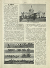
Alberta - 1
Description: Text provides information of different regions of Alberta, their history, and agriculture in Alberta
Publisher: Cummins Map Co.
Province: Alberta
Type: text
Date Issued (Source): 1927
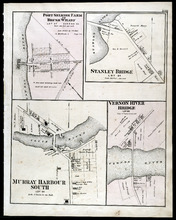
Port Selkirk Farm or Brush Wharf, Stanley Bridge: Murray Harbour South, and Vernon River Bridge
Description: The map shows Port Selkirk Farm or Brush Wharf lot 57 in Queens county. Shown are a river, wharf, road and street, landowners, and measurements. Compass.
Publisher: J. H. Meacham & company
Province: Prince Edward Island
Type: cadastral maps
Date Issued (Source): 1880
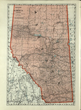
Province of Alberta, Canada
Description: The map shows the province of Alberta, Canada. Shown are bodies of water, rivers, lakes, etc., cities and towns, roads and railroads.
Publisher: Cummins Map Co.
Province: Alberta, British Columbia, Saskatchewan
Type: cadastral maps
Date Issued (Source): 1927
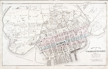
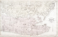
Map of the City of Charlottetown
Description: The map shows the city of Charlottetown. Shown are the wards, roads, landowners and acreage, asylums, ponds, rivers, houses, cemetery, estates, churches, lakes, parks, wharfs, and Charlottetown… more
Publisher: J. H. Meacham & company
Province: Prince Edward Island
Type: cadastral maps
Date Issued (Source): 1880
Alberta - 2
Description: Text provides information of different industries in Alberta, and the population in Alberta
Publisher: Cummins Map Co.
Province: Alberta
Type: text
Date Issued (Source): 1927