Displaying 1 - 5 of 5
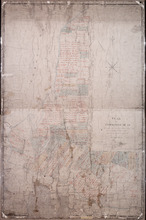
Plan of Township No 15: Taken from the survey of William Cutis (1826) wit alterations and…
Description: Plan of Lot 15 (No.42) taken from the survey of William Curtis (1826) with alterations and corrections from surveys made in 1849 and 1851 by Geo. Wright. Color code shows Crown Lands and lands… more
Province: Prince Edward Island
Type: cadastral maps
Date Created: 1851
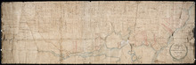
Plan of Township No 63 St. Andrew's Parish Queens County: P.E.Island
Description: Plan of Lot 63. This is one of the plans referred to in the Deed from the Cunards to the Commissioner of Public Lands, July 15, 1866. The map shows lots, residents, roads, acreage and bodies of water… more
Province: Prince Edward Island
Type: cadastral maps
Date Created: 1851
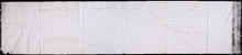
A Plan showing the Position of the Line of Road through, proposes to be run through Lot 47 from…
Description: Plan of existing and proposed road through Lot 47 from George Munn's, West River, to the bridge on the north side of Surveyor's Pond. Distance of 4 miles and 2 chains. Road run under the… more
Province: Prince Edward Island
Type: cadastral maps
Date Created: 1851-08

Plan of Township No. 16 in Prince Edward Island: The Estate of Laurence Sulivan Esq., Dept. Sect.…
Description: Plan of Lot 16, the estate of Lawrence Sullivan, Esq. Copied by Geo. Wright from a plan by James(?).
Province: Prince Edward Island
Type: cadastral maps
Date Created: 1851
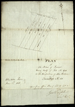
Plan of 50 Acres of Land being half of Lot No. 171 in the Occupation of John Rechore in Township No…
Description: Plan of part of Lot 15. 50 acres of land, part of 171 in the occupation of John Rechore. Also shows (sub) lots 170, 172, 173 and 174. Copied from office plan of Lot 15. (No.3)
Province: Prince Edward Island
Type: cadastral maps
Date Created: 1851-06-03