Displaying 1 - 27 of 171

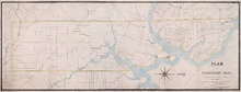
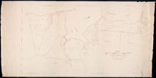
A Plan of Township No 4 Part of the Cunard Estate Prince County P.E.Island
Description: A plan of Lot 4, part of the Cunard Estate. Copied from plans in the Public Lands Department. The map shows lots, residents, bodies of water such as rivers, railways, and roads.
Province: Prince Edward Island
Type: cadastral maps
Date Created: 1885-06

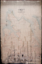
Map of Prince Edward Island
Description: Map of Prince Edward Island. Shows roads, ponds, rivers, towns, cities, grist mills, saw mills, and churches.
Province: Prince Edward Island
Type: cadastral maps

A plan of Charlottetown, the capital of the Island delineated by order of Walter Patterson,…
Description: A plan of Charlottetown, the capital of the Island delineated by order of Walter Patterson, Governor of the said Island (No.2). Includes Charlottetown Common and Royalty. Shows names of some… more
Province: Prince Edward Island
Type: cadastral maps

Plan of Richmond Bay from Curtain Island to Locke Shore : Showing location of Oyster Beds and…
Description: Plan of Richmond Bay from Curtain Island to Locke Shore showing location of Oyster Beds and subdivisions for leasing purposes. (No.1) The map shows residents, lots, measurements, islands, and rivers.
Province: Prince Edward Island
Type: cadastral maps
Date Created: 1912-10-14

Plan of Cascumpec Bay: Showing Sub-divisions to be leased for Oyster Culture
Description: Plan of Cascumpec Bay showing sub-divisions to be leased for Oyster Culture. (No.8) The map shows residents, measurements, lots, rivers, and sand hills.
Province: Prince Edward Island
Type: cadastral maps
Date Created: 1913-11-17

Plan of North River from Victoria Park to North River Bridge: Showing Subdivisions to be leased for…
Description: Plan of North River from Victoria Park to North River Bridge showing subdivisions to be leased for Oyster Culture. (No.5) The map shows residents, lots, measurements, and roads.
Province: Prince Edward Island
Type: cadastral maps
Date Created: 1913-02-15

Plan of Barbara Weit River: Showing Subdivisions to be leased for Oyster Culture.
Description: Plan of Barbara Weit River showing subdivisions to be leased for Oyster Culture. (No.7) The map shows residents, lots, Richmond Bay and measurements.
Province: Prince Edward Island
Type: cadastral maps
Date Created: 1913-09-06
Plan of Foxley River: Showing Subdivisions to be leased for Oyster Culture
Description: Plan of Foxley River showing subdivisions to be leased for Oyster Culture. (No.17). The map shows residents, lots, and measurements.
Province: Prince Edward Island
Type: cadastral maps
Date Created: 1915

Plan of Dockriver: Showing Subdivisions to be leased for Oyster Culture.
Description: Plan of Dock River showing subdivisions to be leased for Oyster Culture. (No.14). The map shows residents, measurements, bays and Fox Island.
Province: Prince Edward Island
Type: cadastral maps
Date Created: 1913-11-17
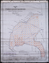
Plan of Trout or Lot 10 River: showing subdivisions to be leased for Oyster Culture
Description: Plan of Trout or Lot 10 River showing subdivisions to be leased for Oyster Culture. (No.18). The map shows redisents, measurements, and a certificate of registration.
Province: Prince Edward Island
Type: cadastral maps
Date Created: 1915
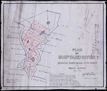
Plan of Shipyard River: showing subdivisions to be leased for Oyster Culture
Description: Plan of Shipyard River showing subdivisions to be leased for Oyster Culture. (No.11). The map shows lots, residents, and measurements, along with a certificate of registration.
Province: Prince Edward Island
Type: cadastral maps
Date Created: 1914
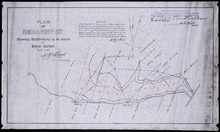
Plan of Indian River: showing subdivisions to be leased for Oyster Culture
Description: Plan of Indian River showing subdivisions to be leased for Oyster Culture. (No.12). The map shows lots, and residents namesm along with measurements of the lots to be leased. Also shown is a… more
Province: Prince Edward Island
Type: cadastral maps
Date Created: 1914
Plan of Township No. 21 and its connexions with adjoining Townships.: Compiled from Surveys by H.J…
Description: Plan of Lot 21 and its connections with adjoining Townships. Shows the names of a few residents north of the South West River. The map also shows many other rivers and creeks, roads, and a nautical… more
Province: Prince Edward Island
Type: cadastral maps
Plan of Township No. 20.: Compiled from Surveys by Jas. Stewart, L. W. Gall, George Wright, Joseph…
Description: Plan of Lot 20. The map shows Lot 20 divided into parcels of land with names of some residents and some acreage amounts. The map notes freehold land. Shows roads in a light brown colour, marsh areas… more
Province: Prince Edward Island
Type: cadastral maps

Plan of that part of Lot or Township No. 55, lying North: lying North of Boughton River shewing the…
Description: Plan of that part of Lot or Township 55 lying north of Boughton River showing the situation of the respective plots as coloured green which are still in the Crown. The map shows bodies of water such… more
Province: Prince Edward Island
Type: cadastral maps
Date Created: 1845

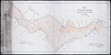
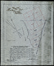
Lot 6: No. 19
Description: Plan of Lot 6 (No. 19). Cunard Estate. Shows names of residents, acreage, and some land conveyance references, bodies of water such as rivers, and roads.
Province: Prince Edward Island
Type: cadastral maps

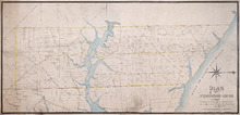
Plan of Township No. 4: Compiled from the plans, leases, deeds, and other documents on file in the…
Description: The map shows Lot 4 divided into parcels of land with the names of residents, their acreage amounts and land conveyance references. The map shows roads in a light brown colour. It shows the P.E.I.… more
Province: Prince Edward Island
Type: cadastral maps
Date Created: 1911-06
Plan of Township No. 11 in Prince Edward Island: Surveyed by A. Anderson Land Surveyor
Description: Plan of Lot 11 (No. 32). Stewart Estate. Shows names, acreage, and land conveyance references for some residents, bodies of water such as coves, rivers, roads, and a nautical compass.
Province: Prince Edward Island
Type: cadastral maps

Plan of Lot or Township No 4, in P.E. Island: The shores and the division Lines coloured according…
Description: Plan of Lot 4. The shores and the division lines colored to yellow are according to actual survey. Shows names of some residents, acreage, roads, and bodies of water such as rivers.
Province: Prince Edward Island
Type: cadastral maps

Plan of a Line of Road from Montague River Bridge to Wood Islands: Run in November 1833
Description: Plan of a line of road from Montague River Bridge to Wood Islands. Passes through Lots 59, 60, 61, and 62. (No.59). Shown are residents, lots, and rivers.
Province: Prince Edward Island
Type: cadastral maps
Date Created: 1833-11
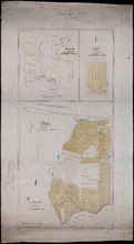
Plan of St. Martins, Township No. 35; Plan of 320 1/2 Acres of Land "Arisaig", Township…
Description: Plan of St. Martins, Lot 35 (south of the Hillsborough River). Also a plan of Arisaig, 320 and a half acres of land on Lot 35 and a plan of that part of Lot 36 north of the Hillsborough River.
Province: Prince Edward Island
Type: cadastral maps
Date Created: 1873
Map of Southport and Rosebank, Prince Edward Island: Drawn by C.D. Lambown Sept. 26, 1953
Description: Map of Southport and Rosebank, Lot.48. Shows names of residents, acreage, cities and towns, and Hillsborough River.
Province: Prince Edward Island
Type: cadastral maps
Date Created: 1953-09-26
Plan of Webber Creek: being supplementary to "Plan of Richmond Bay from Curtain Island to…
Description: Plan of Webber Creek being supplementary to "Plan of Richmond Bay from Curtain Island to Lockes Shore" showing additional plots Nos. 478B, 478C, 478D, and 478E for Oyster Culture. The map… more
Province: Prince Edward Island
Type: plans
Date Created: 1913-10-08

Plan of Township No. 48: compiled during the year 1915 from plans on file in the Land Office and…
Description: Plan of Lot 48 compiled during the year 1915 from plans on file in the Land Office and Registry Office and from the chart of Charlottetown Harbour supplemented by the descriptions in the leases and… more
Province: Prince Edward Island
Type: cadastral maps
Date Created: 1915

Geological Map of Canada and Newfoundland: Derive from the Results of The Canadian Geological…
Description: Framed map of Canada and Newfoundland. The map is has colours for different land marks, and a table that explains it all. Shown are bodies of water such as rivers, islands, roads, towns, and cities.
Province: Newfoundland, New Brunswick, Prince Edward Island, Nova Scotia, Quebec
Type: geological maps
Date Created: 1866 (year uncertain)

Plan of Township No. 32: compiled from the proprietors plans and Meacham's Atlas and from the…
Description: The map shows Lot 32 divided into parcels of land with names of residents, acreage amounts and land conveyance references. Areas drawn in black indicate government land; areas in red indicate… more
Province: Prince Edward Island
Type: cadastral maps
Date Created: 1919-01
Plan of Lot or Township No. 6 in Prince Edward Island: From Actual Survey by A. Anderson, Land…
Description: Plan of Lot 6. Northern half shows residents.
Province: Prince Edward Island
Type: cadastral maps