Displaying 271 - 297 of 504
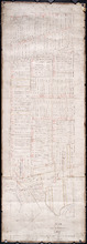
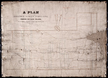
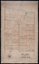
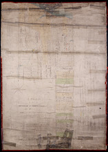
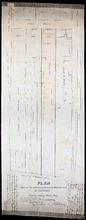
Plan of Lot or Township No. 58: Copied from Surveys of Rodk. Campbell. L. S. by Owen Curtis. L. S.
Description: Plan of Lot 58 (No.155). Shows names of residents, acreage, and land conveyance references. Surveyed by Rod'k Campbell and copied by Owen Curtis. The map shows roads, and bodies of water such as… more
Province: Prince Edward Island
Type: cadastral maps
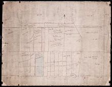
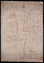
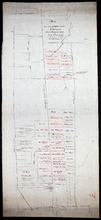
Plan of part of Lot 56
Description: Plan of part of Lot 56 showing the names of residents, acreage, a few land conveyance references, and roads. (No.151)
Province: Prince Edward Island
Type: cadastral maps
Date Created: 1882
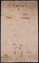
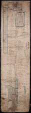
Plan of the Fane Melville and Selkirk Estates on Township No. 53: By Owen Curtis LS
Description: Plan of the Fane, Melville, and Selkirk Estates on Lot 53 (No.142). Unfinished plan. Shows names, acreage, and land conveyance references for some residents. The map also shows roads such as… more
Province: Prince Edward Island
Type: cadastral maps
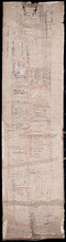
Plan of Part Township No. 53 the Estate of the Honourable Lady Cecily J. G. Fane
Description: Plan of part of Lot 53 (No.143). The estate of the Honourable Lady Cecily J.G. Fane. Shows names of residents and acreage. Signed by G.W. DeBlois, Att'y for Landlord. The map also shows bodies… more
Province: Prince Edward Island
Type: cadastral maps
Plan of that part of Township Number Forty-nine, in Prince Edward Island, the Property of the Hon.…
Description: Plan of part of Lot 49, the property of the Hon. Edward C. Haythorne and Robert Poore Haythorne. Tracts shaded green sold with the Act 28 Vic. Cap.5. (No.133). Shows names of residents and acreage,… more
Province: Prince Edward Island
Type: cadastral maps
Date Created: 1857-01
Plan of the eastern part of Lot 48 and the southern part of Lot 36
Description: Plan of the eastern part of Lot 48 and the southern part of Lot 36. Area around the Monaghan Road. Shows names of residents. (No.132)
Province: Prince Edward Island
Type: cadastral maps
Plan of the Eastern Moiety of Township No. 46 East Parish. Kings County. P. E. Island.
Description: Plan of the eastern moiety of Lot 46, East Parish, Kings Co. (No.125). Cunard Estate. Shows names of residents and acreage, roads, and the Gulf of St. Lawrence. One of the plans referred to in the… more
Province: Prince Edward Island
Type: cadastral maps
Date Created: 1866
A Plan of the Eastern Moiety of Township No. 46 From the Survey of H. J. Cundall L. S. By Owen…
Description: Plan of the eastern half of Lot 46. (No.126) created by Owen Curtis and R.A. Strong from the survey by H.J. Cundall. Shows names of residents, acreage, and land conveyance references, bodies of water… more
Province: Prince Edward Island
Type: cadastral maps
Plan of Township No. 45. Copied from Plan furnished by Proprietors, and amended and corrected from…
Description: Plan of the northern part of Lot 45 copied from Plan furnished by Proprietors and amended and corrected from surveys by J.C. Underhay (No.124). Cunard Estate. Shows names of residents, acreage, land… more
Province: Prince Edward Island
Type: cadastral maps
Plan of part of Lot 44
Description: Plan of part of Lot 44. Area east of the Bear River Road. Shows names of residents.
Province: Prince Edward Island
Type: cadastral maps
Plan of Lot 44 (No.119)
Description: Plan of Lot 44 (No.119). Cunard Estate. Shows names of some residents, acreage, and some land conveyance references, bodies of water such as the Gulf of St. Lawrence, rivers, roads, and a nautical… more
Province: Prince Edward Island
Type: cadastral maps
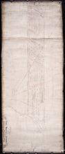
Plan of the southern part of Lot 43
Description: Plan of the southern part of Lot 43. Shows names of residents and acreage, bodies of water such as rivers (Fortune), bays (Rollo), capes, roads, division lines, and a nautical compass. (Townshend)
Province: Prince Edward Island
Type: cadastral maps
A Plan of Part of Township No. Forty Three. The Property of Hon. T. H. Haviland. Surveyed October…
Description: Plan of part of Lot 43. The property of Hon. T.H. Haviland. One of the plans referred to in the Deed from Hon. T.H. Haviland and wife to the Commissioner of Public Lands, 1869. Shows names and… more
Province: Prince Edward Island
Type: cadastral maps
Date Created: 1868-10

Plan of Township No 42: from Surveys by O. Curtis, August 1864
Description: Plan of Lot 42. Shows names of some residents and acreage, bodies of water such as the Gulf of St. Lawrence, roads, and a compass.
Province: Prince Edward Island
Type: cadastral maps
Date Created: 1864-08

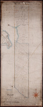
Plan of the western half of Lot 40 and Lot 39 east of Morell River
Description: Plan of the western half of Lot 40 and the part of Lot 39 east of Morell River. Shows names of residents and acreage, bodies of water such as bays, and rivers, and roads.
Province: Prince Edward Island
Type: cadastral maps
A Plan of 1068 Acres of Land on Lot 40, The Property of Hon. T. H. Haviland
Description: Plan of part of Lot 40 (No.108). 1068 acres of land, the property of Hon. T.H. Haviland. One of the plans referred to in the Deed from Hon. T.H. Haviland and wife to the Commissioner of Public Lands… more
Province: Prince Edward Island
Type: cadastral maps
Date Created: 1868-08
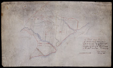
A Map and Survey Of Marshes east of Mount Stewart Bridge on the north side of Hillsborough River in…
Description: A map and survey of marshes east of Mount Stewart Bridge on the north side of Hillsborough River in Lot 37 being formerly part of the Wiggin's Estate. (No.21). Also shown is the Hillsborough… more
Province: Prince Edward Island
Type: cadastral maps
Date Created: 1885-01
A Plan of Glenaladale, The property of the Heirs of the late Honbl. Donald McDonald
Description: Plan of part of Lot 36 (No.98), Glenaladale, the property of the Heirs of the late Hon. Donald McDonald. Shows names of residents, acreage, and a few land conveyance references, bodies of water such… more
Province: Prince Edward Island
Type: cadastral maps
Date Created: 1856
Plan of that part of Township No. Thrity five in Prince Edward Island known by the name of the…
Description: Plan of part of Lot 35 (No.93). Known by the name of Glenfinn Estate, the property of the Heirs of the late Alexander McDonell of Donaldston containing an area of 1609 acres. The map shows roads, and… more
Province: Prince Edward Island
Date Created: 1859-12
Plan of a part of Township Number Thirty Five (35) on the south side of the Hillsborough River.
Description: Plan of Lot 35, south side of the Hillsborough River (No.92). Shows names of residents, acreage, and some land conveyance references, river, and roads.
Province: Prince Edward Island
Type: cadastral maps
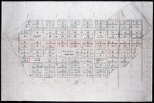
Plan of the city of Charlottetown
Description: Plan of the city of Charlottetown. Shows the location of the 1st to the 5th Hundred and the Town Lots situated thereon.
Province: Prince Edward Island
Type: cartograms map
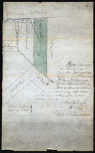
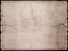
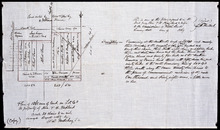
Plan shewing the situation of Malcolm Levingstone's Farm on Lot or Township No. 31, in…
Description: Plan of part of Lot 31. The map shows Malcolm Levingstone's farm of 56 ½ acres, coloured green, on the Baltic Road in Lot 31. The plan also shows the adjoining parcels of land and those on the… more
Province: Prince Edward Island
Type: cadastral maps
Date Created: 1865-12-26
Plan of the property of Mrs. S.W. Smith situated on Township No. 33 in Prince Edward Island
Description: Plan of part of Lot 33. The property of Mrs S.W. Smith. The map shows Winter River, and roads (Brackley Point), (Union), and a compass.
Province: Prince Edward Island
Type: cadastral maps
A Plan of 1068 Acres of Land on Lot 40, The Property of Hon. T. H. Haviland
Description: Plan of part of Lot 40 (No.108). 1068 acres of land, the property of Hon. T.H. Haviland. One of the plans referred to in the Deed from Hon. T.H. Haviland and wife to the Commissioner of Public Lands… more
Province: Prince Edward Island
Type: cadastral maps
Date Created: 1868-08
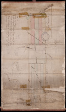
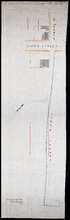
Plan Shewing the situation of that part of Water Lot No. 7. at Charlottetown Sold to Henry Beer Esq.
Description: Plan showing the situation of that part of Water Lot No.7 at Charlottetown sold to Henry Beer. (No.26) (Also No.216 Queens County). The map shows streets such as Great George, Prince, Water, wharfs,… more
Province: Prince Edward Island
Type: cadastral maps
Date Created: 1881
Plan Shewing the situation of Water Lot No. 8, and that part of Water Lot No. 7 conveyed to Ronald…
Description: Plan showing the situation of Water Lot No.8 and that part of Water Lot No.7 conveyed to Ronald MacMillan. The map also shows streets such as Water street, Prince, lots, Ferry Wharf, and Hillsborough… more
Province: Prince Edward Island
Type: cadastral maps
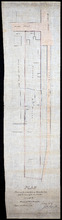
Plan of part of Charlottetown showing Pownal Wharf and Lot No.5
Description: Plan of part of Charlottetown showing Pownal Wharf and part of Town Lot No.5 located in 1st Hund. Also shown are buildings and wharfs.
Province: Prince Edward Island
Date Created: 1868-08