Displaying 1 - 27 of 67
Plan of Richmond Bay from Curtain Island to Malpeque Wharf: Showing location of Oyster Beds and…
Description: Plan of Richmond Bay from Curtain Island to Malpeque Wharf showing location of Oyster Beds and subdivision for leasing purposes. (No.3) The map shows residents, lots, measurements, and islands.
Province: Prince Edward Island
Type: cadastral maps
Date Created: 1912-10-14
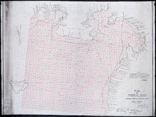
Plan of Pownal Bay: showing the subdivisions to be leased for Oyster Culture
Description: Plan of Pownal Bay showing the subdivisions to be leased for Oyster Culture. (No.13) The map shows residents, lots, measurements, and islands.
Province: Prince Edward Island
Type: cadastral maps
Date Created: 1914

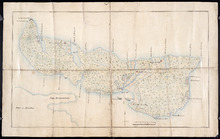
Plan of Richmond Bay from Curtain Island to Locke Shore : Showing location of Oyster Beds and…
Description: Plan of Richmond Bay from Curtain Island to Locke Shore showing location of Oyster Beds and subdivisions for leasing purposes. (No.1) The map shows residents, lots, measurements, islands, and rivers.
Province: Prince Edward Island
Type: cadastral maps
Date Created: 1912-10-14
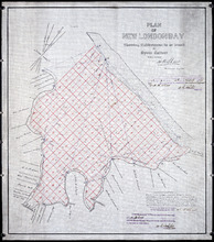
Plan of New London Bay: Showing Sub-divisions to be leased for Oyster Culture
Description: Plan of New London Bay showing sub-divisions to be leased for Oyster Culture. (No.9) The map shows residents, lots, measurements, and sand hills.
Province: Prince Edward Island
Type: cadastral maps
Date Created: 1914

Plan of Cascumpec Bay: Showing Sub-divisions to be leased for Oyster Culture
Description: Plan of Cascumpec Bay showing sub-divisions to be leased for Oyster Culture. (No.8) The map shows residents, measurements, lots, rivers, and sand hills.
Province: Prince Edward Island
Type: cadastral maps
Date Created: 1913-11-17
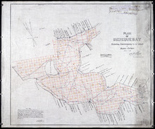
Plan of Bedeque Bay : Showing Sub-divisions to be leased for Oyster Culture
Description: Plan of Bedeque Bay showing sub-divisions to be leased for Oyster Culture. (No.16) The map shows residents, lots, measurements, and Holman's Island. more
Province: Prince Edward Island
Type: cadastral maps
Date Created: 1914-06-01
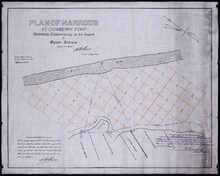
Plan of Narrows at Cranberry Point: showing subdivisions to be leased for Oyster Culture
Description: Plan of Narrows at Cranberry Point (between Cascumpeque and Richmond Bays) showing subdivisions to be leased for Oyster Culture. (No.15). The map shows residents, measurements, sand hills, and a… more
Province: Prince Edward Island
Type: cadastral maps
Date Created: 1914-09-01
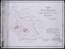
Plan of Oyster Cove: showing subdivisions to be leased for Oyster Culture
Description: Plan of Oyster Cove showing subdivisions to be leased for Oyster Culture. (No.6). The map shows redisents, measurements, and Richmond Bay.
Province: Prince Edward Island
Type: cadastral maps
Date Created: 1913-08-15
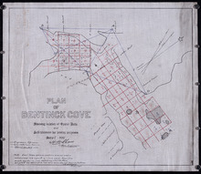
Plan of Bentinck Cove: Showing location of Oyster Beds and subdivisions for leasing purposes/
Description: Plan of Bentinck Cove showing location of Oyster Beds and subdivisions for leasing purposes. (No.4) The map shows lots, residents, and measurements of those lots.
Province: Prince Edward Island
Type: cadastral maps
Date Created: 1913-03-20

Lot 6: No. 19
Description: Plan of Lot 6 (No. 19). Cunard Estate. Shows names of residents, acreage, and some land conveyance references, bodies of water such as rivers, and roads.
Province: Prince Edward Island
Type: cadastral maps
Plan of Township No. 11 in Prince Edward Island: Surveyed by A. Anderson Land Surveyor
Description: Plan of Lot 11 (No. 32). Stewart Estate. Shows names, acreage, and land conveyance references for some residents, bodies of water such as coves, rivers, roads, and a nautical compass.
Province: Prince Edward Island
Type: cadastral maps
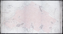
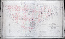
Plan of Richmond Bay from Grand River to Malpeque Harbour: showing location of Oyster Beds and…
Description: Plan of Richmond Bay from Grand River to Malpeque Harbour showing location of Oyster Beds and subdivisions for leasing purposes. (No.2) The map shows resdients, lots, measurements, islands, rivers,… more
Province: Prince Edward Island
Type: cadastral maps
Date Created: 1912-10-14
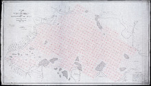
Plan of Richmond Bay from Grand River to Malpeque Harbour: Showing location of Oyster Beds and…
Description: Plan of Richmond Bay from Grand River to Malpeque Harbour showing location of Oyster Beds and subdivisions for leasing purposes. (No.2) The map shows residents, lots, measurements, islands, ponds and… more
Province: Prince Edward Island
Type: cadastral maps
Date Created: 1912-10-14

Plan of Township No. 33 in Prince Edward Island: Part of the Estate of John Hodges Winsloe Esq.…
Description: Plan of Lot 33. Winsloe Estate.
Province: Prince Edward Island
Type: cadastral maps
Date Created: 1834-09-20
Lot 43: No. 1
Description: Plan of Lot 43 (No.1), showing Bay Fortune, Rollo Bay and North Shore areas.
Province: Prince Edward Island
Type: cadastral maps

Plan of Township No. 64: St. Andrews Parish, Queens County, P. E. Island
Description: Lot 64 is situated in Kings County, not Queens County as stated in the map title. The map shows Lot 64 divided into parcels of land with names of residents and their acreage amounts. Several parcels… more
Province: Prince Edward Island
Type: cadastral maps
Date Created: 1850

Plan of Lot or Township No. 34
Description: Plan of Lot 34 (No. 90). Montgomery Estate. Working plan. The map shows Lot 34 divided into parcels of land with the names of residents and their acreage amounts handwritten in black ink. Land… more
Province: Prince Edward Island
Type: cadastral maps
A New and Accurate Map of the Islands of Newfoundland, Cape Briton, St. John and Anticosta:…
Description: Map, showing the Maritime provinces; the vertical fold indicates that it originally appeared in a book or atlas; cartouche in bottom right corner. Port Joy is the only settlement named on Isle St.… more
Publisher: Astron Obervat
Province: Nova Scotia, Newfoundland, Cape Breton, St. John, Anticosta
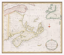
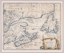
A New and Accurate Map of the Province of Nova Scotia, in North America, From the Latest…
Description: Framed map of the province of Nova Scotia and vicinity. The map shows bodies of water such as the Gulf of St. Lawrence and Bay of Fundy, towns, cities, villages, islands, banks, and a compass rose.
Province: Nova Scotia
Type: topographic maps, pictorial maps
Date Created: 1773

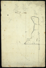
Plan Shewing the position of the Northern points of Commencement of the Lines dividing Lots 33 and…
Description: The map shows northern portions of Lots 24, 33, 34 and 35 along the north shore of Prince Edward Island. It shows the northern-most sections of three boundary lines: the line dividing Lots 24 and 33… more
Province: Prince Edward Island
Type: chorographic maps
Date Created: 1835-05-07

Plan of Township No. 64: compiled from the proprietors' plans, descriptions in leases and…
Description: The map shows Lot 64 divided into parcels of land with names of residents, their acreage amounts and land conveyence references. Land information written in black indicates government land;… more
Province: Prince Edward Island
Type: cadastral maps
Date Created: 1920
Plan of Île Saint-Jean: The Island of Saint John
Description: Plan of Ile Saint-Jean / the Island of Saint John. The map shows Prince Edward Island and a portion of the mainland. It identifies settlements, bays, harbours, rivers and islands. Sandy areas are… more
Province: Prince Edward Island
Type: topographic maps
Date Created: 1760
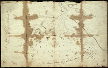
Entrance to the Croppo River
Description: Plan of part of Lot 29 (No.4). Entrance to Croppo River. Shows soundings at Crapaud Harbour. The map shows the harbour and entrance to the Crapaud (or Westmoreland) River. Soundings appear to be… more
Province: Prince Edward Island
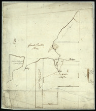
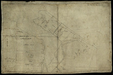
Part of Lot 33: Area around Rustico Bay
Description: Plan of part of Lot 33. Area around Rustico Bay. The map shows the area around Rustico Bay in the northwest part of Lot 33. It shows the land divided into parcels with names of some residents and… more
Province: Prince Edward Island
Type: cadastral maps
Parts of Lot 33: Two maps showing the northern extremities of the east and west boundaries of Lot 33
Description: Plans of two parts of Lot 33 (No.4): McMillan's Point; Grand Pere Point. This item consists of 2 maps on one sheet--one each on the front and back. Side One shows McMillan Point on Covehead Bay… more
Province: Prince Edward Island
Type: boundary maps
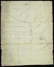
Part of Lot 34
Description: Plan of part of Lot 34 (No.5). Shows properties of John Millar, L. Brown, Neil Shaw, Murdock McCloud, and John Crabtree. The map shows the northwestern portion of Lot 34 divided into parcels of land… more
Province: Prince Edward Island
Type: cadastral maps
Part of Lot 34
Description: Plan of part of Lot 34 (No.3). Area around Covehead Bay. The map shows the northwestern portion of Lot 34, divided into parcels of land with the names of residents and/or proprietors and their… more
Province: Prince Edward Island
Type: cadastral maps