Displaying 325 - 351 of 539

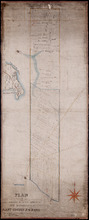
Plan of the Western Portion of Township No. 65: containing 5250 acres and belonging to Mrs. Lydia…
Description: Plan of the western portion of Lot 65 (No.173). Estate of Mrs Lydia Wright. Roads, leased land[?] and freehold land on the Estate of Mrs. Lydia Wright. Tenant names appear on the sub-lots, which are… more
Province: Prince Edward Island
Type: cadastral maps
Date Created: 1841

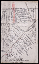
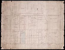
Plan of Lot or Township No. 34
Description: Plan of Lot 34 (No. 90). Montgomery Estate. Working plan. The map shows Lot 34 divided into parcels of land with the names of residents and their acreage amounts handwritten in black ink. Land… more
Province: Prince Edward Island
Type: cadastral maps
Plan of the Division Line between Queens and Prince Counties & the Southern Boundary of…
Description: Plan of the division line between Queens and Prince Counties and the southern boundary of Lot 25 established by the Commissioners under the Boundary Line Act. Certified copy by G. Wright of 1835 plan… more
Province: Prince Edward Island
Type: boundary maps
Date Created: 1850
Plan of the Division Line between Queens and Prince Counties, & the Southern Boundary of…
Description: Plan of the division line between Queens and Prince Counties and the southern boundary of Lot 25, as established by the Commissioners under the Boundary Line Act. (No.81). The map shows the boundary… more
Province: Prince Edward Island
Type: boundary maps
Date Created: 1835
Plan of the Line dividing Kings and Queens Counties in Prince Edward Island as established by the…
Description: Plan of the line dividing Kings and Queens Counties in Prince Edward Island as established by the Commissioners under the provisions of the Act 4th: William 4th: Cap. 15 (No. 80). The map shows the… more
Province: Prince Edward Island
Type: boundary maps
Date Created: 1835

Office copy of that part of the Plan of the new line of Road leading from the Cardigan River to the…
Description: Plan of the new line of road leading from the Cardigan River to the Hillsborough River. Passes through Lots 51, 52, and 38. Plan copied by Geo. Wright, 12 August, 1837. The plan uses a dashed and… more
Province: Prince Edward Island
Type: engineering maps
Date Created: 1833
Plan of land appropriated by the Railway Commissioners in Lots 38 and 51
Description: Prince Edward Island Railway. Plan shows the land appropriated by the Railway Commissioners in Lots 38 and 51. The rail line is drawn in pink. Roads are shown in a lighter colour. Names of residents… more
Province: Prince Edward Island
Type: engineering maps
Plan of 500 Acres of Land as fixed on by Mr. Langdon being part of Mrs. Burns Land of 7800 Acres.:…
Description: Plan of part of Lot 38 (No. 5). 500 acres, the property of Mr. Langdon, being part of Mrs. Burns' land of 7800 acres. The maps shows a square parcel of land, 500 acres in size, belonging to Mr.… more
Province: Prince Edward Island
Type: cadastral maps
Date Created: 1809-08
Plan Shewing the Northern Boundary Line of the Victoria Park Roadway as Surveyed by Thomas W. May L…
Description: Plan showing the northern boundary line of the Victoria Park Roadway. This is the plan referred to in "The Victoria Park Roadway Act, 1896". Shown is the Charlottetown Harbour, Governor… more
Province: Prince Edward Island
Type: cadastral maps
Date Created: 1896

Plan Shewing the Eligible Situation of Acre Lots on the Estate of the Honble. J. C. Pope. in the…
Description: Plan showing the eligible situation of acre lots on the estate of Hon. J.C. Pope in the Royalty of the city of Charlottetown. Royalty Lots No.85, No.95 and No.97. (No.386)
Province: Prince Edward Island
Type: cadastral maps
Date Created: 1878
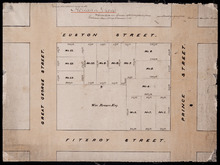
Holland Grove
Description: Plan of the block of land between Euston Street and Fitzroy Street and Prince Street and Great George Street known as Holland Grove. Town Lots 18-22 and 63-67 in the fifth hundred.
Province: Prince Edward Island
Type: cadastral maps
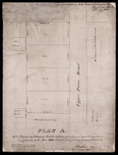
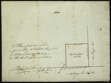
Plan A. Of 4 Pleasantly Situated Building Lots, fronting on Upper Prince Street, The property of…
Description: Plan "A" of four pleasantly situated lots fronting on Upper Prince Street, the property of the Hon. T.H. Haviland, Common Lot No.24. (No.60) more
Province: Prince Edward Island
Type: cadastral maps
Date Created: 1886

Plan of St. Avard's divided into Building Lots part of the Estate of the Honble. James C. Pope…
Description: Plan of St. Avards divided into building lots, part of the estate of the Hon. James C. Pope in the Royalty of Charlottetown. Royalty Lot No.13. Also shown are St. Peters Road, and Mt. Stewart Road.
Province: Prince Edward Island
Type: cadastral maps
Date Created: 1878

Plan showing the situation of part of the Estate of the late Owen Connolly Esq. in Charlottetown…
Description: Plan showing the situation of part of the Estate of the late Owen Connolly in Charlottetown Common and Royalty. Created by John Ball, surveyor, and copied by Thomas W. May. The map shows Malpeque… more
Province: Prince Edward Island
Type: cadastral maps
Date Created: 1921-01

Plan of Lot 41
Description: Plan of Lot 41. Shows names of some residents. The map also shows St. Peters Bay and the Gulf of St. Lawrence.
Province: Prince Edward Island
Type: cadastral maps

Plan of 1390 Acres of Land part of Township No. 65: The property of the Hon,, Smauel Cunard…
Description: Plan of part of Lot 65 (No.172). 1390 acres of land, part of the property of the Hon. Samuel Cunard. One of the plans referred to in the Deed from Sir Edward, William, and Laura Cunard to the… more
Province: Prince Edward Island
Type: cadastral maps
Date Created: 1866-07-13

Plan of Township No. 54: Chiefly from Surveys by Geo. Wright and Rodk. Campbell copied By Owen…
Description: Plan of Lot 54, chiefly from surveys by Geo. Wright and Rod'k Campbell. Copied by Owen Curtis, 1877. Shows names of residents, acreage, and land conveyance references, roads, bodies of water,… more
Province: Prince Edward Island
Type: cadastral maps
Date Created: 1877
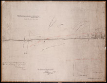
Plan of an approximate correction of the Junction of the Maitland road with the Murray Harbour Road…
Description: Plan of an approximate correction of the Junction of the Maitland Road with the Murray Harbour Road as sketched in sundry plans by the late Roderick Campbell... and as measured on the ground on the… more
Province: Prince Edward Island
Type: cadastral maps
Date Created: 1921-09-09
Plan of Lot or Township No. 58: Copied from Surveys of Rodk. Campbell. L. S. by Owen Curtis. L. S.
Description: Plan of Lot 58 (No.155). Shows names of residents, acreage, and land conveyance references. Surveyed by Rod'k Campbell and copied by Owen Curtis. The map shows roads, and bodies of water such as… more
Province: Prince Edward Island
Type: cadastral maps
Plan of part of Lot 56
Description: Plan of part of Lot 56 showing the names of residents, acreage, a few land conveyance references, and roads. (No.151)
Province: Prince Edward Island
Type: cadastral maps
Date Created: 1882
Plan of the Fane Melville and Selkirk Estates on Township No. 53: By Owen Curtis LS
Description: Plan of the Fane, Melville, and Selkirk Estates on Lot 53 (No.142). Unfinished plan. Shows names, acreage, and land conveyance references for some residents. The map also shows roads such as… more
Province: Prince Edward Island
Type: cadastral maps
Plan of Part Township No. 53 the Estate of the Honourable Lady Cecily J. G. Fane
Description: Plan of part of Lot 53 (No.143). The estate of the Honourable Lady Cecily J.G. Fane. Shows names of residents and acreage. Signed by G.W. DeBlois, Att'y for Landlord. The map also shows bodies… more
Province: Prince Edward Island
Type: cadastral maps

Plan of that part of Township Number Forty-nine, in Prince Edward Island, the Property of the Hon.…
Description: Plan of part of Lot 49, the property of the Hon. Edward C. Haythorne and Robert Poore Haythorne. Tracts shaded green sold with the Act 28 Vic. Cap.5. (No.133). Shows names of residents and acreage,… more
Province: Prince Edward Island
Type: cadastral maps
Date Created: 1857-01
Plan of the eastern part of Lot 48 and the southern part of Lot 36
Description: Plan of the eastern part of Lot 48 and the southern part of Lot 36. Area around the Monaghan Road. Shows names of residents. (No.132)
Province: Prince Edward Island
Type: cadastral maps

Plan of the Eastern Moiety of Township No. 46 East Parish. Kings County. P. E. Island.
Description: Plan of the eastern moiety of Lot 46, East Parish, Kings Co. (No.125). Cunard Estate. Shows names of residents and acreage, roads, and the Gulf of St. Lawrence. One of the plans referred to in the… more
Province: Prince Edward Island
Type: cadastral maps
Date Created: 1866

A Plan of the Eastern Moiety of Township No. 46 From the Survey of H. J. Cundall L. S. By Owen…
Description: Plan of the eastern half of Lot 46. (No.126) created by Owen Curtis and R.A. Strong from the survey by H.J. Cundall. Shows names of residents, acreage, and land conveyance references, bodies of water… more
Province: Prince Edward Island
Type: cadastral maps