Displaying 1 - 6 of 6
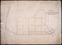
Plan of Pierce Gaul's Estate Montague-Bridge
Description: Plan of Pierce Gaul's Estate, Montague Bridge, Lot No.52. The map shows the Montague River, streets, and buildings. more
Province: Prince Edward Island
Type: cadastral maps
Date Created: 1877-05
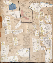
Montague Bridge P.E.I.
Description: This is a fire insurance plan of the village of Montague Bridge consisting of two (2) maps--one for each side of the Montague River. It was created in 1888 and revised to 1910. The map on the left… more
Publisher: Chas. E. Goad, Civil Engineer
Province: Prince Edward Island
Type: fire insurance maps
Date Created: 1888-10
Date Modified: 1910-09
Date Issued (Source): 1888
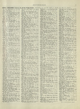
Rural Directory - Lot 51, 52, and 66, Kings County
Description: A directory listing of residents of lot 51, 52, and 66
Publisher: Cummins Map Co.
Province: Prince Edward Island
Type: text
Date Issued (Source): 1927
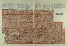
Lots 51, 52, and 66: Kings County
Description: The map shows lots 51, 52, and 66 in Kings County. Shown are Brown Creek, Montague River, Landowners, acreage, roads, and railroads.
Publisher: Cummins Map Co.
Province: Prince Edward Island
Type: cadastral maps
Date Issued (Source): 1927
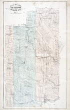
Plan of Lots 51, 52, & 66: Kings Co., P.E.I.
Description: The map shows lots 51, 52, & 66 in Kings county. Shown are roads, railroads and stations, landowners and acreage, streams, rivers, post offices, mills, and churches. Graphic compass.
Publisher: J. H. Meacham & company
Province: Prince Edward Island
Type: cadastral maps
Date Issued (Source): 1880

Montague Bridge Lots 59 & 52: Kings Co., P.E.I.
Description: The map shows lots 59 & 52 in Montague Bridge, Kings county. Shown are rivers, wharfs, shipyards, roads, landowners and acreage, halls, churches, buildings and businesses. Compass.
Publisher: J. H. Meacham & company
Province: Prince Edward Island
Type: cadastral maps
Date Issued (Source): 1880