Displaying 1 - 9 of 9

Plan of Lot or Township No. 51 in Kings County P. E. Island
Description: Plan of Lot 51 (No.139) Colour code shows freehold and unsold portions. Sir Graham Montgomery Estate. Shows names, acreage, and land conveyance references of some residents, and roads.
Province: Prince Edward Island
Type: cadastral maps
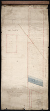
Plan shewing the situation of a new line of road from Baldwin's Road, Lot 51 to Brother's…
Description: Plan showing the situation of a new line of road from Baldwin's Road, Lot 51 to Brother's Road, Lot 66 more
Province: Prince Edward Island
Type: cadastral maps
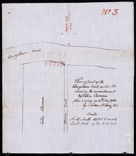
Plan of part of the Georgetown Road on Lot 51 showing the encrouchment by John Curran from a survey…
Description: Plan of part of the Georgetown Road on Lot 51. Shows Union Road and property of John Curran. (No.3) The map shows lots, resident, and roads.
Province: Prince Edward Island
Type: cadastral maps
Date Created: 1908-06-04
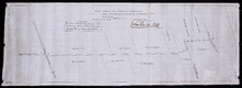
Plan of land appropriated by the Railway Commissioners in Lots 38 and 51
Description: Prince Edward Island Railway. Plan shows the land appropriated by the Railway Commissioners in Lots 38 and 51. The rail line is drawn in pink. Roads are shown in a lighter colour. Names of residents… more
Province: Prince Edward Island
Type: engineering maps
A Plan of the Eastern or C Division of Lot or Township No. 51: St. Georges Parish, Kings Coutnry, P…
Description: Plan of the eastern division of Lot 51. Montgomery Estate. The map shows the C Division of Lot 51 divided into numbered parcels of land with the names of owners or occupants with their corresponding… more
Province: Prince Edward Island
Type: cadastral maps

Plan of Lot or Township No. 51 in Kings County Prince Edward Island: Surveyed by G. Wright Jr. in…
Description: Plan of Lot 51 (No.141). Shows residents, lots, bodies of water such as rivers, and roads.
Province: Prince Edward Island
Type: cadastral maps
Date Created: 1836
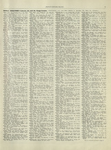
Rural Directory - Lot 51, 52, and 66, Kings County
Description: A directory listing of residents of lot 51, 52, and 66
Publisher: Cummins Map Co.
Province: Prince Edward Island
Type: text
Date Issued (Source): 1927
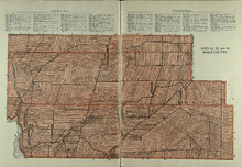
Lots 51, 52, and 66: Kings County
Description: The map shows lots 51, 52, and 66 in Kings County. Shown are Brown Creek, Montague River, Landowners, acreage, roads, and railroads.
Publisher: Cummins Map Co.
Province: Prince Edward Island
Type: cadastral maps
Date Issued (Source): 1927
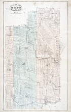
Plan of Lots 51, 52, & 66: Kings Co., P.E.I.
Description: The map shows lots 51, 52, & 66 in Kings county. Shown are roads, railroads and stations, landowners and acreage, streams, rivers, post offices, mills, and churches. Graphic compass.
Publisher: J. H. Meacham & company
Province: Prince Edward Island
Type: cadastral maps
Date Issued (Source): 1880