Displaying 1 - 9 of 9

Plan of the Western Portion of Township No. 65: containing 5250 acres and belonging to Mrs. Lydia…
Description: Plan of the western portion of Lot 65 (No.173). Estate of Mrs Lydia Wright. Roads, leased land[?] and freehold land on the Estate of Mrs. Lydia Wright. Tenant names appear on the sub-lots, which are… more
Province: Prince Edward Island
Type: cadastral maps
Date Created: 1841

Lot 30: Refugee Share drawn for in Council this 18th day of September 1784, John Spencer
Description: Plan of Lot 30 (No.1) showing Refugee Shares drawn for in Council, 18 September, 1784.
Province: Prince Edward Island
Type: cadastral maps
Date Created: 1784

Plan of Township No. 30 belonging to R. Bruce Stewart, Drawn by Robt. Stewart 1861 from surveys…
Description: The map shows Lot 30 divided into numbered sub-lots. There are nine different series of sub-lot numbers which are colour-coded according to the map legend. The different colours represent Line Road,… more
Province: Prince Edward Island
Type: cadastral maps
Date Created: 1861

Plan of Township 30
Description: Plan of Lot 30 (No.82). Stewart Estate. Shows names of residents.
Province: Prince Edward Island
Type: cadastral maps

Plan of the Western Portion of Township No. 65: containing 5250 acres and belonging to Mrs. Lydia…
Description: Plan of the western portion of Lot 65 (No.173). Estate of Mrs Lydia Wright. Roads, leased land[?] and freehold land on the Estate of Mrs. Lydia Wright. Tenant names appear on the sub-lots, which are… more
Province: Prince Edward Island
Type: cadastral maps
Date Created: 1841
Rural Directory - Lots 24, 29, and 30, Queens County
Description: A directory listing of residents of lots 24, 29, and 30
Publisher: Cummins Map Co.
Province: Prince Edward Island
Type: text
Date Issued (Source): 1927
Rural Directory - Lots 29 and 30, Queens County
Description: A directory listing of residents of lots 29 and 30.
Publisher: Cummins Map Co.
Province: Prince Edward Island
Type: text
Date Issued (Source): 1927
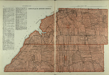
Lots 29 and 30: Queens County
Description: The map shows lots 29 and 30 in Queens county. Shown are roads, landowners, acreage, the Northumberland Strait, Westmoreland Harbour, and Sable River.
Publisher: Cummins Map Co.
Province: Prince Edward Island
Type: cadastral maps
Date Issued (Source): 1927
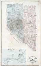
Plan of Lots Twenty Nine & Thirty: Queens Co., P.E.I.
Description: The map shows lots 29 (coloured in blue) and 30 (coloured in pink) in Queens county. The map shows straits, rivers, post offices, roads, landowners and acreage, and churches. Graphic compass.
Publisher: J. H. Meacham & company
Province: Prince Edward Island
Type: cadastral maps
Date Issued (Source): 1880