Displaying 1 - 8 of 8
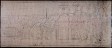
Plan of Township No. 16 in Prince Edward Island: The Property Of Miss Sullivan
Description: Plan of Lot 16 (No.44). The property of Miss Sullivan. Shows names of residents, bodies of water, roads, and a compass. Color code shows freehold lands purchased from the Proprietor and other… more
Province: Prince Edward Island
Type: cadastral maps

Plan of Part of Railway Line on Lot No. 16
Description: Plan of part of the Railway Line on Lot 16. The map shows roads, lots, water, and residents.
Province: Prince Edward Island
Type: cadastral maps
Date Created: 1872-04-30

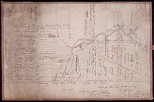
Plan of Part of the Railway Line on Lots No. 16 and 17
Description: Plan of part of the Railway Line on Lots 16 and 17. Appropriations from Lot 16 to the French purchase. The map shows roads, lots, residents, and acreage.
Province: Prince Edward Island
Type: cadastral maps
Date Created: 1872-04-29

Plan of Township No. 16 in Prince Edward Island: The Estate of Laurence Sulivan Esq., Dept. Sect.…
Description: Plan of Lot 16, the estate of Lawrence Sullivan, Esq. Copied by Geo. Wright from a plan by James(?).
Province: Prince Edward Island
Type: cadastral maps
Date Created: 1851
Plan of the western part of Lot 16
Description: Plan of the western part of Lot 16. Shows names of residents, acreage, and a few land conveyance references. The map shows bodies of water, roads, other lots such as 15, and 18 in Indian River, a… more
Province: Prince Edward Island
Type: cadastral maps
Date Created: 1880-01-24
Lots 14 and 16 : Prince County
Description: The map shows lots 14 and 16, in Prince county. Shown are bays, ponds, coves, landowners, acreage, rivers, and roads.
Publisher: Cummins Map Co.
Province: Prince Edward Island
Type: cadastral maps
Date Issued (Source): 1927

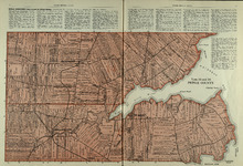
Plan of Lot Fourteen & Sixteen : Prince Co., P.E.I.
Description: Map shows lots fourteen & sixteen in Prince county. Shown are roads, creeks, coves, rivers, post offices, railroads and stations, ferries, points, bays, landowners, acreage, churches, and… more
Publisher: J. H. Meacham & company
Province: Prince Edward Island
Type: cadastral maps
Date Issued (Source): 1880

Plan of Lot Twenty Seven: Prince Co., P.E.I.
Description: The map shows lot 27 in Prince county. The map shows roads, railroads, crosses, ponds, rivers, bays, straits, coves, mills, post offices, and churhces. Graphic compass.
Publisher: J. H. Meacham & company
Province: Prince Edward Island
Type: cadastral maps
Date Issued (Source): 1880