Displaying 1 - 9 of 9
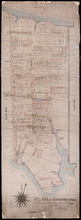
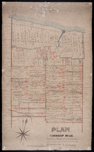
Plan of Township No. 44. Corrected from Surveys by Owen Curtis, J. C. Underhay and others. By Thos…
Description: Plan of Lot 44 (No.118) corrected by Thomas MacKinlay from surveys by Owen Curtis, J.C. Underhay and others. Cunard Estate. Shows some residents' names, acreage, and land conveyance references,… more
Province: Prince Edward Island
Type: cadastral maps
Date Created: 1887-09
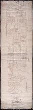
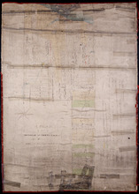
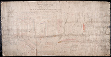
A Plan of Lot or Township No. 43, Comprising the Haviland, Townsend, and Worrell Estates. Compiled…
Description: Plan of Lot 43 (No.116) comprising the Haviland, Townshend, and Worrell Estates. Completed from the surveys of J. Ball and J.C. Underhay by Owen Curtis. Shows names of residents, acreage, and land… more
Province: Prince Edward Island
Type: cadastral maps
Date Created: 1876-08
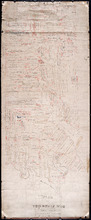
Plan of Township No. 56: Copied from the Survey of J. C. Underhay By Owen Curtis. L. S.
Description: Plan of Lot 56 (No.150). Shows names of residents, acreage, and some land conveyance references. Surveyed by J.C. Underhay and copied by Owen Curtis. The map also shows bodies of water such as… more
Province: Prince Edward Island
Type: cadastral maps
Plan of part of Lot 56
Description: Plan of part of Lot 56 showing the names of residents, acreage, a few land conveyance references, and roads. (No.151)
Province: Prince Edward Island
Type: cadastral maps
Date Created: 1882
Plan of Township No. 45. Copied from Plan furnished by Proprietors, and amended and corrected from…
Description: Plan of the northern part of Lot 45 copied from Plan furnished by Proprietors and amended and corrected from surveys by J.C. Underhay (No.124). Cunard Estate. Shows names of residents, acreage, land… more
Province: Prince Edward Island
Type: cadastral maps
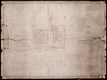
A Plan of Part of Township No. Forty Three. The Property of Hon. T. H. Haviland. Surveyed October…
Description: Plan of part of Lot 43. The property of Hon. T.H. Haviland. One of the plans referred to in the Deed from Hon. T.H. Haviland and wife to the Commissioner of Public Lands, 1869. Shows names and… more
Province: Prince Edward Island
Type: cadastral maps
Date Created: 1868-10
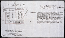
A Plan of 1068 Acres of Land on Lot 40, The Property of Hon. T. H. Haviland
Description: Plan of part of Lot 40 (No.108). 1068 acres of land, the property of Hon. T.H. Haviland. One of the plans referred to in the Deed from Hon. T.H. Haviland and wife to the Commissioner of Public Lands… more
Province: Prince Edward Island
Type: cadastral maps
Date Created: 1868-08
A Plan of Township No. 56 in Kings County P. E. Island, the Property of Hon. T. H. Haviland of…
Description: Plan of Lot 56 (No.149). Property of Hon. T.H. Haviland of Charlottetown. Shows names of residents and acreage, bodies of water such as rivers, bays, creeks, ponds, roads, and a nautical compass.
Province: Prince Edward Island
Type: cadastral maps
Date Created: 1864