Displaying 1 - 4 of 4
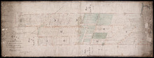
Plan of Lot 51 (No.140)
Description: Plan of Lot 51 (No.140). The property of Sir Graham G. Montgomery and others. True copy from a survey made in August, 1838, by George Wright. Copied by Jas. Bevan, 1852. Shows names of residents and… more
Type: cadastral maps
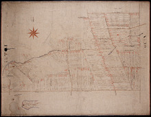
Plan of Lot 57
Description: Plan of Lot 57 (No.153). Selkirk Estate. Shows names of residents, acreage, and land conveyance references. A copy from the plan conveying the Estate to the Government and signed by John Aldous. The… more
Type: cadastral maps
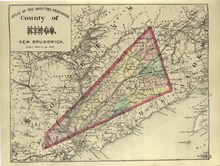
County of Kings, New Brunswick
Description: The map shows the county of Kings in New Brunswick. Shown are rivers, railroads and stations, roads, and lakes. Atlas of the Maritime Provinces of the Dominion of Canada with historical and… more
Publisher: Roe Brothers
Type: geographical maps
Date Issued (Source): 1878
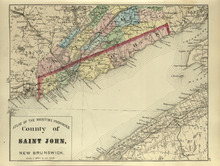
County of St. John, New Brunswick
Description: The map shows the county of St. John in New Brunswick. Shown are harbours, coves, rivers, railroads, towns, and cities. Atlas of the Maritime Provinces of the Dominion of Canada with historical and… more
Publisher: Roe Brothers
Type: geographical maps
Date Issued (Source): 1878