Displaying 1 - 4 of 4
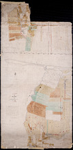
A Plan of part of Township No. 36
Description: A plan of the estate of the late Hon. Donald McDonald comprising part of Lots 35 and 36 divided and apportioned into six shares by Messrs. Aldous, Cundall, and Haythorne under power of an agreement… more
Province: Prince Edward Island
Type: cadastral maps
Date Created: 1865-02-03
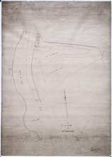
A Plan of Souris Beach
Description: Plan of part of Lots 44 and 45, Souris Beach. The map shows dry spots at low water, lots, and residents.
Province: Prince Edward Island
Type: cadastral maps
Date Created: 1866
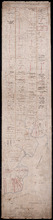
A Plan of Lot No. 61: By John Aldous from survey made in May & June 1842
Description: Plan of Lot 61 (No.162). Sullivan Estate. Landlord's plan. Shows names of residents and acreage. Signed by G.W. DeBlois. The map shows roads, bodies of water such as Sturgeon Bay and River,… more
Province: Prince Edward Island
Type: cadastral maps
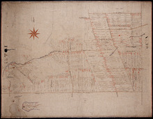
Plan of Lot 57
Description: Plan of Lot 57 (No.153). Selkirk Estate. Shows names of residents, acreage, and land conveyance references. A copy from the plan conveying the Estate to the Government and signed by John Aldous. The… more
Type: cadastral maps