Displaying 1 - 27 of 297

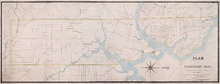
Common Lot No 21 as divided into Building Lots
Description: Plan of Common Lot No.21. Charlottetown as divided into building lots. (No.380) The map shows lots, acreage and roads/streets.
Province: Prince Edward Island
Type: cadastral maps
Date Created: 1872-08
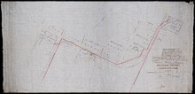
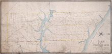
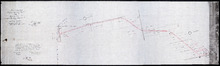
P.E.Island Railway: Charlottetown
Description: Prince Edward Island Railway. Charlottetown. Appropriations into Charlottetown Station. The map shows roads, streets, lots, and buildings.
Province: Prince Edward Island
Type: plans
Date Created: 1871

Plan de l'Ȋle de St. Jean au Nord de l'Acadie et dans le Sud du Golfe de St. Laurent.:…
Description: Plan de l'Ȋle de St. Jean. Par Ordre de M. de Sartine, Conseiller d'Etat, Ministre et Secretaire d'Etat au Département de la Marine. The map shows the province of Prince Edward Island… more
Publisher: Sartine, M. de
Province: Prince Edward Island
Type: topographic maps
Date Created: 1778

A plan of Charlottetown, the capital of the Island delineated by order of Walter Patterson,…
Description: A plan of Charlottetown, the capital of the Island delineated by order of Walter Patterson, Governor of the said Island (No.2). Includes Charlottetown Common and Royalty. Shows names of some… more
Province: Prince Edward Island
Type: cadastral maps

Plan of the Royalty of Charlottetown: from a survey taken in the year 1831 by Order of His…
Description: "Plan of the Royalty of Charlottetown from a survey taken in the year 1831 by Order of His Excellency Lieutenant Governor Ready." Shows Royalty Lot numbers, and acreage. (No.67) more
Province: Prince Edward Island
Type: cadastral maps
Date Created: 1831

Plan Shewing lands in Charlottetown Appropriated fro Railway purposes : The Figures 67 &c.…
Description: Plan showing lands in Charlottetown appropriated for Railway purposes. The map shows lots, residents, streets, and wharfs.
Province: Prince Edward Island
Type: cadastral maps
Plan Shewing Lands in the Common and Royalty of Charlottetown appropriated for Railway purposes.
Description: Plan showing land in the Common and Royalty of Charlottetown appropriated for Railway purposes. The map shows lots, acreage, roads, cities and towns.
Province: Prince Edward Island
Type: cadastral maps
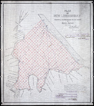
Plan of New London Bay: Showing Sub-divisions to be leased for Oyster Culture
Description: Plan of New London Bay showing sub-divisions to be leased for Oyster Culture. (No.9) The map shows residents, lots, measurements, and sand hills.
Province: Prince Edward Island
Type: cadastral maps
Date Created: 1914

Plan of North River from Victoria Park to North River Bridge: Showing Subdivisions to be leased for…
Description: Plan of North River from Victoria Park to North River Bridge showing subdivisions to be leased for Oyster Culture. (No.5) The map shows residents, lots, measurements, and roads.
Province: Prince Edward Island
Type: cadastral maps
Date Created: 1913-02-15
Plan showing 0.604 acres of land acquired from Leo Praught, Lot 50, for the Provincial Highway
Description: Plan showing 0.604 acres of land acquired from Leo Praught, Lot 50, for the Provincial Highway. The map shows measurements, acres, some residents and roads and where those roads lead too.
Province: Prince Edward Island
Type: cadastral maps
Date Created: 1939-05

Plan of part of Lot 49: Tea Hill, Charlottetown Exchange.
Description: Plan of part of Lot 49. Tea Hill. Charlottetown Exchange. Shows property owned by the Island Telephone Co. Ltd. (Grid co-ordinates)
Province: Prince Edward Island
Type: cadastral maps
Plan of Township No. 21 and its connexions with adjoining Townships.: Compiled from Surveys by H.J…
Description: Plan of Lot 21 and its connections with adjoining Townships. Shows the names of a few residents north of the South West River. The map also shows many other rivers and creeks, roads, and a nautical… more
Province: Prince Edward Island
Type: cadastral maps

Plan of Charlotte Town Shewing the true position of the Streets and the encroachments thereon.…
Description: The map shows the street grid, numbered town lots and public squares of Charlottetown. It shows some buildings and some of the roads leading to/from the town.
Province: Prince Edward Island
Type: plans
Date Created: 1833
Plan of Township No. 20.: Compiled from Surveys by Jas. Stewart, L. W. Gall, George Wright, Joseph…
Description: Plan of Lot 20. The map shows Lot 20 divided into parcels of land with names of some residents and some acreage amounts. The map notes freehold land. Shows roads in a light brown colour, marsh areas… more
Province: Prince Edward Island
Type: cadastral maps
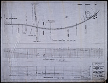
Plan of Proposed Railway Crossing North River to Mount Edward Roads
Description: Plan of proposed Railway crossing North River to Mount Edward Road. Department of Public Works and Highways, Province of Prince Edward Island. Plan shows 3 drawings consisting of the Railway &… more
Province: Prince Edward Island
Type: cadastral maps, transportation maps
Date Created: 1949
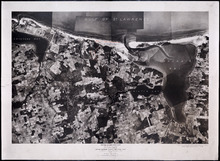
Prince Edward Island National Park: Covehead - Tracadie Section 1937
Description: Prince Edward Island National Park. Covehead - Tracadie section. Lots 34 and 35. Aerial photograph. Department of Mines and Resources, Mines and Geology Branch. Bureau of Geology and Topography. The… more
Province: Prince Edward Island
Type: cadastral maps, aerial photographs
Date Created: 1937

Prince Edward Island National Park: New London - Rustico Section 1937
Description: Prince Edward Island National Park, New London - Rustico section, Lots 22, 23 and 24. Aerial photograph. Department of Mines and Resources, Mines and Geology Branch, Bureau of Geology and Topography.
Province: Prince Edward Island
Type: cadastral maps
Date Created: 1937

Prince Edward Island National Park: Rustico Island and Brackley Beach Sections
Description: Prince Edward Island National Park. Rustico Island and Brackley Beach sections. Lots 24, 33 and 34. Department of Mines and Resources, Mines and Geology Branch, Bureau of Geology and Topography.
Province: Prince Edward Island
Type: cadastral maps, geological maps
Date Created: 1937

Prince Edward Island Nova Scotia and New Brunswick: Prince, Queens and Kings Counties, P.E.I.…
Description: Prince, Queens and Kings Counties, Prince Edward Island, portions of New Brunswick, Nova Scotia, and Magdalen Islands. It marks counties, parishes, cities, towns, and villages, beaches, marshes, Lots… more
Publisher: Hydrographic and Map Service, Labelle Building
Province: Prince Edward Island, Nova Scotia, New Brunswick, Quebec
Type: cadastral maps
Date Created: 1940

Plan of a Line of Road from Montague River Bridge to Wood Islands: Run in November 1833
Description: Plan of a line of road from Montague River Bridge to Wood Islands. Passes through Lots 59, 60, 61, and 62. (No.59). Shown are residents, lots, and rivers.
Province: Prince Edward Island
Type: cadastral maps
Date Created: 1833-11
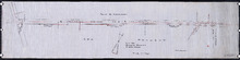
P.E.I. Railway Murray Harbour Branch : Plan Branch Line From Village Green to Vernon River Bridge
Description: Prince Edward Island Railway. Murray Harbour Branch. Plan of the branch line from Village Green to Vernon River Bridge (No.588). Plan produced by Wm. B. MacKenzie, Chief Engineer. The map shows lots… more
Province: Prince Edward Island
Type: cadastral maps
Date Created: 1906-05-28
Plan No 1 Office of the Registar of Deeds: Charlottetown P.E.Island
Description: Plan of land appropriated for the construction of the Murray Harbour Branch Railway through Queen's County (No.1). Plan produced by Wm. B. MacKenzie, Chief Engineer. The map shows residents,… more
Province: Prince Edward Island
Type: cadastral maps
Date Created: 1900-06-07
Plan of Cape Traverse Branch: Prince Edward Island Railway
Description: Canadian Government Railways, Prince Edward Island. Cape Traverse subdivision. Plans of the Railway right of way from Emerald Junction to Port Borden. Copied from the plans in the Engineer's… more
Province: Prince Edward Island
Type: cadastral maps
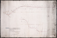
Railway appropriations from Hunter River to Clyde Station: Lots 22 and 23
Description: Railway appropriations from Hunter River to Clyde Station. Lots 22 and 23. The map shows residents and acreage, roads, stations, ponds, and foliage.
Province: Prince Edward Island
Type: cadastral maps
Date Created: 1872
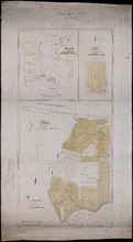
Plan of St. Martins, Township No. 35; Plan of 320 1/2 Acres of Land "Arisaig", Township…
Description: Plan of St. Martins, Lot 35 (south of the Hillsborough River). Also a plan of Arisaig, 320 and a half acres of land on Lot 35 and a plan of that part of Lot 36 north of the Hillsborough River.
Province: Prince Edward Island
Type: cadastral maps
Date Created: 1873

Plan of Township No. 67, and its environs.: Compiled from Surveys by Geo. Wright; H.J. Cundall;…
Description: Plan of Lot 67 and its environs. Compiled from surveys by Geo. Wright, H.J. Cundall, Joseph Ball, and Owen Curtis. Drawn by Thomas MacKinlay. Shows names of some residents, roads, railroads, bodies… more
Province: Prince Edward Island
Type: cadastral maps
Date Created: 1877-08-01

Stanhope Shore Rd.
Description: The map shows the Stanhope Shore Road with the names of residents, their road frontage measurements and dollar amounts for each.
Province: Prince Edward Island
Type: cadastral maps
Date Created: 1954