Displaying 82 - 108 of 201

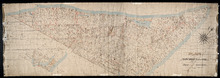
A Trace of West Coast, Prince Edward Island: from the Survey by Capt. Bayfield, R.N. furnished at…
Description: Plan of the West Coast of Prince Edward Island from the survey by Capt. Bayfield furnished at the request of a Committee of the House of Assembly, March 18, 1842. The coast line marked in red has… more
Province: Prince Edward Island
Type: cadastral maps
Date Created: 1842
Tracing of Plan of the North Moiety of Township No. 26: The property of the Messrs Thompson of…
Description: Tracing of Plan of the North Moiety of Lot 26, the property of the Messrs. Thompson of Belfast, Ireland. Documents attached. The map shows lots, residents, roads, acreage, and bodies of water.
Province: Prince Edward Island
Type: cadastral maps
Date Created: 1875-11-05

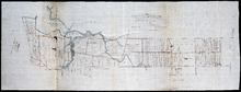
Plan of Part of Railway Line on Lot No. 16
Description: Plan of part of the Railway Line on Lot 16. The map shows roads, lots, water, and residents.
Province: Prince Edward Island
Type: cadastral maps
Date Created: 1872-04-30
Plan of part of the Railway appropriation in Lots 5 and 6
Description: Plan of part of the Railway appropriation in Lots 5 and 6. Shown are lots, roads, and residents.
Province: Prince Edward Island
Type: cadastral maps, transportation maps
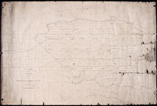
Office Copy of Plan No. 5 of the Royalty of George Town: by Jos. Ball D. S. Gl. June 7th 1853
Description: The map shows the numbered town lots and street grid of Georgetown. It gives the acreage amounts of a few of the town lots. The names of some residents have been added in pencil. The map shows… more
Province: Prince Edward Island
Type: plans
Date Created: 1853-06-07

Plan of Lot 2
Description: The map shows Lot 2 divided into parcels of land. It provides the names of residents, their acreage amounts and some land conveyance references for most of the east end of the lot and for a small… more
Province: Prince Edward Island
Type: cadastral maps

Plan of Part of the Railway Line on Lots No. 16 and 17
Description: Plan of part of the Railway Line on Lots 16 and 17. Appropriations from Lot 16 to the French purchase. The map shows roads, lots, residents, and acreage.
Province: Prince Edward Island
Type: cadastral maps
Date Created: 1872-04-29

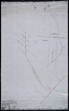
Plan of Part of the Railway Line on Lot No. 17: Shewing the Stations Grounds at Summerside.
Description: Plan of part of the Railway Line on Lot 17 showing the Station Grounds at Summerside (No.2). Former location of the appropriations from Linkletter Road into Summerside. The map shows roads, lots,… more
Province: Prince Edward Island
Type: cadastral maps
Date Created: 1872-04-29
Paln No. 1 of Railway Appropriation: from Alberton to Tignish
Description: Plan of Railway Appropriations from Alberton to Tignish. (Plan No.1). The map shows roads, resdients, acreage, lots, and foliage.
Province: Prince Edward Island
Type: cadastral maps
Date Created: 1873
Plan No. 2 of Railway Appopriation: From Alberton to Tignish
Description: Plan of Railway Appropriations from Alberton to Tignish. (Plan No.2). The map shows roads, lots, residents, acreage, and foliage.
Province: Prince Edward Island
Type: cadastral maps
Date Created: 1873

Plan of Alberton: Surveyed by John Ball, Land Surveyor
Description: Plan of part of Alberton, Lot 4. Shows names of residents and land conveyance references, bodies of water such as bays, and creeks, and roads.
Province: Prince Edward Island
Type: cadastral maps
Date Created: 1871-08
Plan of Township No. 3: Copied from Mr. Andersons Plan 1847 by Geo. Wright
Description: Plan of Lot 3 showing the Township divided into 21 lots. Plan copied by Geo. Wright. The map shows names of residents, acreage, roads, rivers, and capes.
Province: Prince Edward Island
Type: cadastral maps
Date Created: 1847

Plan of Lot 2 (No.7)
Description: Plan of Lot 2 (No.7). Cunard Estate. The map shows residents, and acreage, bodies of water, roads, and a division line.
Province: Prince Edward Island
Type: cadastral maps

Plan of Lot 2
Description: Plan of Lot 2 showing names of residents, acreage, and some land conveyance references, rivers, and roads.
Province: Prince Edward Island
Type: cadastral maps

Plan of Lot 2
Description: Plan of Lot 2. Plan referred to in the deed from Sir Edward, William and Laura Cunard to the Commissioner of Public Lands. Shows names of some residents, also gives some land conveyance references,… more
Province: Prince Edward Island
Type: cadastral maps
Date Created: 1866

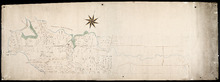
Plan of the Western Moiety of Lot or Township 1 : Part of ot copied and part from actual survey by…
Description: Plan of the western moiety of Lot 1 (No.2), part of it copied and part from actual survey. Palmer Estate. The map shows residents and land acreage, ponds, and roads.
Province: Prince Edward Island
Type: cadastral maps
Date Created: 1854-08-05

Plan of Township No. 2: Compiled from the Proprietors Plans and partial surveys
Description: Plan of Lot 2 (No.5). Compiled from the Proprietors Plans and partial surveys by John Ball, Public Lands Department. Cunard Estate. Shows the names of residents, former occupants, and land conveyance… more
Province: Prince Edward Island
Type: cadastral maps
Date Created: 1885-10
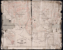
Plan of Lot 28: Prince Co. P.E.I.
Description: Printed map of Lot 28. Names and land conveyance references have been added in red ink. The map shows residents, lots, roads, bodies of water such as rivers, towns, and cities, buildings, and an… more
Province: Prince Edward Island
Type: cadastral maps

Plan of Township No. 9: compiled from the proprietors' plans and the descriptions in the…
Description: Plan of Lot 9 compiled from the proprietors plans and the descriptions in the leases and deeds, with additions and corrections from the various surveys. The map shows Lot 9 divided into parcels of… more
Province: Prince Edward Island
Type: cadastral maps
Date Created: 1909

Plan of Township No. 11: compiled from the plans by the late Alexander Anderson L. S on file in the…
Description: The map shows Lot 11 divided into parcels of land with names of residents, their acreage amounts and land conveyance references. Shows the P.E.I. Railway in red, roads in light brown. Bodies of water… more
Province: Prince Edward Island
Type: cadastral maps
Date Created: 1910
Plan of Lot 1
Description: Plan of Lot 1 comprising the Palmer and part of the Cunard Estates. Surveyed by V.S. Gillis and others. Rolled map on fabric backing. Water is coloured blue. Properties include owner / occupant names… more
Province: Prince Edward Island
Type: cadastral maps
Date Created: Unknown year

Plan of Lot or Township No. 6 in Prince Edward Island: From Actual Survey by A. Anderson, Land…
Description: Plan of Lot 6. Northern half shows residents.
Province: Prince Edward Island
Type: cadastral maps

Plan of Township No. 13: From a Survey by Alex Anderson Copied from a Plan made by John Clay…
Description: Plan of Lot 13 - Yeo Estate.
Province: Prince Edward Island
Type: cadastral maps
Date Created: 1878

Plan of Township No. 16 in Prince Edward Island: The Estate of Laurence Sulivan Esq., Dept. Sect.…
Description: Plan of Lot 16, the estate of Lawrence Sullivan, Esq. Copied by Geo. Wright from a plan by James(?).
Province: Prince Edward Island
Type: cadastral maps
Date Created: 1851
A Plan of Lot 18: situated in Prince County in the Island of St. John enlarged and Drawn from the…
Description: Sketch plan of Lot 18 (Plan No.46) showing property of Peter Stewart, Robert Stewart, and Wm. Allanby. Surveyed by Thomas Wright. Office copy by Jos. Ball and certified by Geo. Wright. Original was… more
Province: Prince Edward Island
Type: cadastral maps
Date Created: 1847-04-06
Lot 26
Description: Plan of Lot 26, partly finished by T. McKinlay. Residents shown for southern part of lot.
Province: Prince Edward Island
Type: cadastral maps