Displaying 1 - 27 of 27

Prince Edward Island Nova Scotia and New Brunswick: Prince, Queens and Kings Counties, P.E.I.…
Description: Prince, Queens and Kings Counties, Prince Edward Island, portions of New Brunswick, Nova Scotia, and Magdalen Islands. It marks counties, parishes, cities, towns, and villages, beaches, marshes, Lots… more
Publisher: Hydrographic and Map Service, Labelle Building
Province: Prince Edward Island, Nova Scotia, New Brunswick, Quebec
Type: cadastral maps
Date Created: 1940

Plan de l'Ȋle de St. Jean au Nord de l'Acadie et dans le Sud du Golfe de St. Laurent.:…
Description: Plan de l'Ȋle de St. Jean. Par Ordre de M. de Sartine, Conseiller d'Etat, Ministre et Secretaire d'Etat au Département de la Marine. The map shows the province of Prince Edward Island… more
Publisher: Sartine, M. de
Province: Prince Edward Island
Type: topographic maps
Date Created: 1778

Map of Prince Edward Island in the Gulf of St. Lawrence: for McGregor's British America
Publisher: Ballantyne and Company
Province: Prince Edward Island
Type: cadastral maps, topographic maps
Date Created: 1832

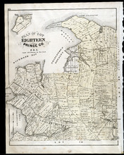
Plan of Lot One: Prince Co., P.E.I.
Description: Map showing the northWestern tip of the island. It names the gulfs, rivers, ponds, landowners and acreage, roads, and railroads. A graphic compass.
Publisher: J. H. Meacham & company
Province: Prince Edward Island
Type: cadastral maps
Date Issued (Source): 1880

Plan of Lot Six: Prince Co., P.E.I.
Description: Map showing lot six, bordering lots 5, 9, 10, 11 in Prince county. Shows rivers, creeks, railroads, roads, landowners, acreage, post offices, and buildings. Geographical compass
Publisher: J. H. Meacham & company
Province: Prince Edward Island
Type: cadastral maps
Date Issued (Source): 1880

Plan of Lots Two : Prince Co., P.E.I.
Description: Map showing lots 2
Publisher: J. H. Meacham & company
Province: Prince Edward Island
Type: cadastral maps
Date Issued (Source): 1880

Plan of Lot Seven: Prince Co., P.E.I.
Description: Map showing lot seven, bordering lots 4, 5, 6, and 8 in Prince county. Shows gulfs, railroads, roads, landowners, acreage, post offices, and buildings. Geographical compass
Publisher: J. H. Meacham & company
Province: Prince Edward Island
Type: cadastral maps
Date Issued (Source): 1880

Tignish, Prince Co.: Campbellton
Description: The map shows Lot 1 in Tignish, Prince county. Shown are roads, landowners and acreage, a church, chapel, and convent, a cemetery, railroad and station, grammar school, business, and houses. Compass.
Publisher: J. H. Meacham & company
Province: Prince Edward Island
Type: cadastral maps
Date Issued (Source): 1880

Plan of Lot Four : Prince Co., P.E.I.
Description: Map showing lots four
Publisher: J. H. Meacham & company
Province: Prince Edward Island
Type: cadastral maps
Date Issued (Source): 1880

Plan of Lot Eight: Prince Co., P.E.I.
Description: The map shows lot 8 in Prince county. Shown are roads, landowners and acreage, rivers, Northumberland strait, ponds, lighthouses, post offices, churches, mills, and businesses. Compass.
Publisher: J. H. Meacham & company
Province: Prince Edward Island
Type: cadastral maps
Date Issued (Source): 1880

Plan of Lot Thirteen: Prince Co., P.E.I.
Description: Map showing lot thirteen, bordering lots 12, 14 and 15, in Prince county. Shows gulfs, straits, bays, rivers, ponds, creeks, railroads, roads, landowners, acreage, post offices, and buildings.… more
Publisher: J. H. Meacham & company
Province: Prince Edward Island
Type: cadastral maps
Date Issued (Source): 1880

Plan of Lot Nine: Prince Co., P.E.I.
Description: The map shows lot 9 in Prince county. Shown are roads, landowners and acreage, Egmont bay, sand, Brae river, post offices, railroad and station, schools and churches. Compass.
Publisher: J. H. Meacham & company
Province: Prince Edward Island
Type: cadastral maps
Date Issued (Source): 1880

Plan of Lot Fourteen & Sixteen : Prince Co., P.E.I.
Description: Map shows lots fourteen & sixteen in Prince county. Shown are roads, creeks, coves, rivers, post offices, railroads and stations, ferries, points, bays, landowners, acreage, churches, and… more
Publisher: J. H. Meacham & company
Province: Prince Edward Island
Type: cadastral maps
Date Issued (Source): 1880

Plan of Lot Ten: Prince Co., P.E.I.
Description: The map shows lot 10 in Prince county. Shown are roads, rivers and creeks, railroad and station, post offices, a school, and landowners and acreage. Compass.
Publisher: J. H. Meacham & company
Province: Prince Edward Island
Type: cadastral maps
Date Issued (Source): 1880
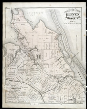
Plan of Lot Eleven: Prince Co., P.E.I.
Description: The map shows lot 11 in Prince county. Shown are roads, landowners and acreage, rivers, bays, coves, creeks, ponds, sand, railroad and station, post offices, and school houses. Compass.
Publisher: J. H. Meacham & company
Province: Prince Edward Island
Type: cadastral maps
Date Issued (Source): 1880

Victoria, Lot 29; Map of Lennox Island
Description: The page displays map of Victoria in Lot 29. Shown are roads and streets, a harbour, wharfs, landowners, post offices, buildings and school houses. Compass. The page also displays a map of Lennox… more
Publisher: J. H. Meacham & company
Province: Prince Edward Island
Type: cadastral maps
Date Issued (Source): 1880
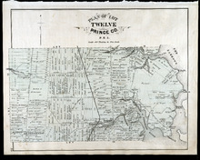
Plan of Lot Twelve: Prince Co., P.E.I.
Description: The map shows lot 12 in Prince county. Shown are the Narrows, roads, railroad and station, ponds, landowners and acreage, school houses, creeks, rivers, and coves.
Publisher: J. H. Meacham & company
Province: Prince Edward Island
Type: cadastral maps
Date Issued (Source): 1880
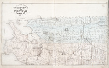
Plan of Lots Twenty Five & Twenty Six: Prince Co., P.E.I.
Description: The map shows lots 25 and 26 in Prince county. The map names roads, landowners and acreage, railroads, post offices, churches, harbours, lighthouses, hotels, coves. and rivers. Graphic compass.
Publisher: J. H. Meacham & company
Province: Prince Edward Island
Type: cadastral maps
Date Issued (Source): 1880
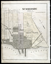
Summerside: Prince Co., P.E.I.
Description: The map shows the city of Summerside. Shown are the wards, a corportion line, landowners and acreage, roads, cemetery, buildings, railroad wharfs, and a harbour.
Publisher: J. H. Meacham & company
Province: Prince Edward Island
Type: cadastral maps
Date Issued (Source): 1880

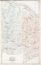
Plan of Lot Twenty Seven: Prince Co., P.E.I.
Description: The map shows lot 27 in Prince county. The map shows roads, railroads, crosses, ponds, rivers, bays, straits, coves, mills, post offices, and churhces. Graphic compass.
Publisher: J. H. Meacham & company
Province: Prince Edward Island
Type: cadastral maps
Date Issued (Source): 1880
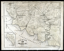
Plan of Lot 28: Prince Co., P.E.I.
Description: The map shows lot 28 in Prince county. Shown are straits, coves, rivers, Anglo-American cable, Winter Crossing Ice Boats, post offices, churches, landowners and acreage, and factories. Compass.
Publisher: J. H. Meacham & company
Province: Prince Edward Island
Type: cadastral maps
Date Issued (Source): 1880
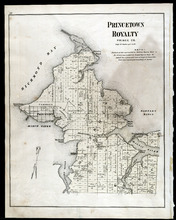
Princetown Royalty: Prince Co., P.E.I.
Description: The map shows Princetown Royalty, in Prince county. Shown are Bays, a basin, rivers, commons, sand, points, wharfs, churches, cemetery, post offices, roads, and landowners.
Publisher: J. H. Meacham & company
Province: Prince Edward Island
Type: cadastral maps
Date Issued (Source): 1880
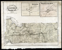
Plan of Lot Nineteen: Prince Co., P.E.I.
Description: The map shows lot 19 in Prince county. Shown are creeks, bays, roads, railroads and stations, landowners and acerage, post offices and buildings. Compass.
Publisher: J. H. Meacham & company
Province: Prince Edward Island
Type: cadastral maps
Date Issued (Source): 1880
Plan of Lots 33 & 34: Queens Co., P.E.I.
Description: The map shows lots 33 (coloured in blue) & 34 (coloured in pink) in Queens county. The map shows roads, railroads and stations, landowners and acreage, farms, post offices, churches, hotels,… more
Publisher: J. H. Meacham & company
Province: Prince Edward Island
Type: cadastral maps
Date Issued (Source): 1880
Plan of Lot Eighteen: Prince Co., P.E.I.
Description: The map shows lot 18 in Prince county. Shown are bays, capes, points, coves, post offices, schools, creeks, mills, churches, landowners and acreage, and roads. Compass.
Publisher: J. H. Meacham & company
Province: Prince Edward Island
Type: cadastral maps
Date Issued (Source): 1880
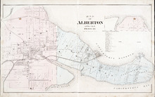
Map of Alberton Lots 4 & 5: Prince Co., P.E.I.
Description: The map shows lots 4 & 5 in the town of Alberton, Prince county. Shown are rivers, creeks, lakes, wharfs, shipyard, roads, railroad, landowners and acreage, mills, churches and cemetery. Compass… more
Publisher: J. H. Meacham & company
Province: Prince Edward Island
Type: cadastral maps
Date Issued (Source): 1880
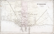
Summerside: Prince Co.
Description: The map shows the city of Summerside. Shown are the wards, roads, landowners and acreage, harbour, barracks, schools, squares, shipyards, railroad and station, and wharfs. Compass.
Publisher: J. H. Meacham & company
Province: Prince Edward Island
Type: cadastral maps
Date Issued (Source): 1880