Displaying 1 - 11 of 11
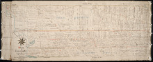
Plan of Railway appropriations in Lots 26, 27 and 28
Description: Plan of Railway appropriations in Lots 26, 27 and 28. The map shows lots, roads, residents, and acreage.
Province: Prince Edward Island
Type: cadastral maps, transportation maps

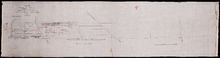
Plan of a proposed new line of road from Middleton Road to Isaac Ive's Millas coloured brown…
Description: Plan of a proposed new line of road from Middleton Road to Isaac Ive's Mill connecting with the road already opened from Searletown to Ive's Mill thro. part of Lot 27. The map shows lots,… more
Province: Prince Edward Island
Type: cadastral maps
Plan of Township 27: embracing Freeholds and the Pope and Cunard Estates. Compiled from Meacham…
Description: Plan of Lot 27 (No.73) embracing freeholds and the Pope and Cunard Estates. Compiled from Meacham's Atlas and the original leases. more
Province: Prince Edward Island
Type: cadastral maps
Date Created: 1885-09
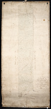
A Plan of the Northern half Lot or Township No. 27 in Prince Edward Island: from an Actual Survey…
Description: Outline plan of northern half of Lot 27 (No.2).
Province: Prince Edward Island
Type: cadastral maps
Date Created: 1818
Plan of Lot 27 Prince County: The Property of James P.
Description: Plan of the northern part of Lot 27 (No.72). Pope Estate. Shows names of residents and acreage, the Northumberland Strait, mill pond, and roads. Plan referred to in the Deed from Pope to the… more
Province: Prince Edward Island
Type: cadastral maps
Plan of Part of the Estate of R.B. Stewart Esq. Situate on Lot or Township No. 27 shewing the…
Description: Plan of part of Lot 27. Estate of R.B. Stewart. Shows names of residents, acreage, and a few land conveyance references, roads, and the sea shore.
Province: Prince Edward Island
Type: cadastral maps
Date Created: 1848-03-24
A Plan of Part of Lot No. XXVII Situat in P.E.I. the Property of J. Cambridge Esq. from an Actual…
Description: Plan of part of Lot 27 (No.74). The property of J. Cambridge. Shows names of residents and acreage, Carlton Cove and a compass. Plan is one of those referred to in the Deed from Sir Edward, William… more
Province: Prince Edward Island
Type: cadastral maps
Date Created: 1828-08
Copy of Plan of part of Lot 27 Prince County P.E.I. Purchased from Hon. J. C. Pope
Description: Copy of plan of part of Lot 27 purchased from Hon. J.C. Pope. The plan is referred to in the Deed from James Colledge Pope and his wife to the Commissioner of Public Lands, July 13, 1868. The map… more
Province: Prince Edward Island
Type: cadastral maps
Date Created: 1868
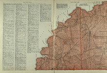
Lots 27 and 28: Prince County
Description: The map shows lots 27 and 28 in Prince county. Shown are the Northumberland Strait, points, coves, landowners, acreage, roads, and a railroad.
Publisher: Cummins Map Co.
Province: Prince Edward Island
Type: cadastral maps
Date Issued (Source): 1927
Rural Directory - Lots 27 and 28, Prince County and Lot 67, Queens county
Description: A directory listing of residents of lots 27 and 28 in Prince County and lot 67 in Queens County
Publisher: Cummins Map Co.
Province: Prince Edward Island
Type: text
Date Issued (Source): 1927

Plan of Lot Twenty Seven: Prince Co., P.E.I.
Description: The map shows lot 27 in Prince county. The map shows roads, railroads, crosses, ponds, rivers, bays, straits, coves, mills, post offices, and churhces. Graphic compass.
Publisher: J. H. Meacham & company
Province: Prince Edward Island
Type: cadastral maps
Date Issued (Source): 1880