Displaying 1 - 10 of 10
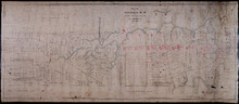
Plan of part of The Western Road.: W. Curtis
Description: (No. 46). The map shows a plan of the Western Road from St. Eleanor's to Lot 10. The road passes through Lots 10, 11, 12, 13, 14, 16 and 17. The map shows part of the Ellis River and other… more
Province: Prince Edward Island
Type: plans
Plan of Township No. 16 in Prince Edward Island: The Property Of Miss Sullivan
Description: Plan of Lot 16 (No.44). The property of Miss Sullivan. Shows names of residents, bodies of water, roads, and a compass. Color code shows freehold lands purchased from the Proprietor and other… more
Province: Prince Edward Island
Type: cadastral maps

Plan of Part of Railway Line on Lot No. 16
Description: Plan of part of the Railway Line on Lot 16. The map shows roads, lots, water, and residents.
Province: Prince Edward Island
Type: cadastral maps
Date Created: 1872-04-30

Plan of Part of the Railway Line on Lots No. 16 and 17
Description: Plan of part of the Railway Line on Lots 16 and 17. Appropriations from Lot 16 to the French purchase. The map shows roads, lots, residents, and acreage.
Province: Prince Edward Island
Type: cadastral maps
Date Created: 1872-04-29

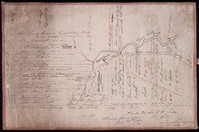
Plan of Township No. 16 in Prince Edward Island: The Estate of Laurence Sulivan Esq., Dept. Sect.…
Description: Plan of Lot 16, the estate of Lawrence Sullivan, Esq. Copied by Geo. Wright from a plan by James(?).
Province: Prince Edward Island
Type: cadastral maps
Date Created: 1851
Plan of the western part of Lot 16
Description: Plan of the western part of Lot 16. Shows names of residents, acreage, and a few land conveyance references. The map shows bodies of water, roads, other lots such as 15, and 18 in Indian River, a… more
Province: Prince Edward Island
Type: cadastral maps
Date Created: 1880-01-24
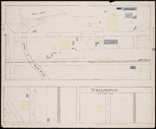
Wellington, Lot 16
Description: This item is a fire insurance plan of the community of Wellington. It shows the village in three (3) sections that are intended to be continuous. The largest map section, across the top of the sheet… more
Province: Prince Edward Island
Type: fire insurance maps
Date Issued (Source): 1888
Lots 14 and 16 : Prince County
Description: The map shows lots 14 and 16, in Prince county. Shown are bays, ponds, coves, landowners, acreage, rivers, and roads.
Publisher: Cummins Map Co.
Province: Prince Edward Island
Type: cadastral maps
Date Issued (Source): 1927

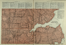
Plan of Lot Fourteen & Sixteen : Prince Co., P.E.I.
Description: Map shows lots fourteen & sixteen in Prince county. Shown are roads, creeks, coves, rivers, post offices, railroads and stations, ferries, points, bays, landowners, acreage, churches, and… more
Publisher: J. H. Meacham & company
Province: Prince Edward Island
Type: cadastral maps
Date Issued (Source): 1880

Plan of Lot Twenty Seven: Prince Co., P.E.I.
Description: The map shows lot 27 in Prince county. The map shows roads, railroads, crosses, ponds, rivers, bays, straits, coves, mills, post offices, and churhces. Graphic compass.
Publisher: J. H. Meacham & company
Province: Prince Edward Island
Type: cadastral maps
Date Issued (Source): 1880