Displaying 28 - 54 of 147
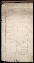
A Plan of the North or C Division of Lot or Township No. 59: Kings County, P. E. Island
Description: A plan of the north division of Lot 59 (No.159). James Montgomery Estate. The map shows the C Division of Lot 59 divided into numbered parcels of land with the names of occupants and their… more
Province: Prince Edward Island
Type: cadastral maps

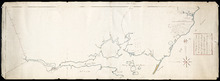
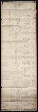
Plan of Lot or Township No 59 Two Thirds being the property of Sir James Montgomery Brothers being…
Description: Plan of Lot 59. Two thirds being the property of Sir James Montgomery & Brothers, and one third the property of Earl Selkirk. The map shows bodies of water such as rivers, residents, lots, and… more
Province: Prince Edward Island
Type: cadastral maps
Date Created: 1842-03-01
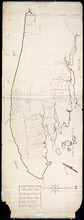
Lot 50
Description: Plan of Lot 63 (No.2). The property of J. Cambridge. Mainly outline. Shows a few residents, lots, bodies of water, islands, and roads.
Province: Prince Edward Island
Type: cadastral maps
Date Created: 1829-04

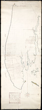
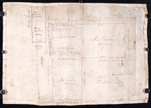
Plan of Township No 63, St. Andrews Parish Kings County: Prince Edward Island
Description: Plan of Lot 63. Eastern part shows names of residents, lots, acreage, bodies of water such as rivers, and bays, and roads.
Province: Prince Edward Island
Type: cadastral maps
Date Created: 1842

Plan of Township No 63 St. Andrew's Parish Queens County: P.E.Island
Description: Plan of Lot 63. This is one of the plans referred to in the Deed from the Cunards to the Commissioner of Public Lands, July 15, 1866. The map shows lots, residents, roads, acreage and bodies of water… more
Province: Prince Edward Island
Type: cadastral maps
Date Created: 1851
A Plan of Lot No 64: The property of J. Cambridge Esq Situate in Kings County P.E.Island
Description: Plan of Lot 64. The property of J. Cambridge. Shows some residents. Copy by James Richard. The map shows lots, residents, roads, cities, towns, and bodies of water.
Province: Prince Edward Island
Type: cadastral maps
Date Created: 1829-03
A Plan of Lot No. LXIV: The Property of J. Cambridge Esqr. Situate in Kings County P. E. Island…
Description: Plan of Lot 64 (No. 2). The property of J. Cambridge. The map shows Lot 64 partially divided into parcels of land with the names of residents and their acreage amounts. The map shows roads, which are… more
Province: Prince Edward Island
Type: cadastral maps
Date Created: 1829-03
Plan of Lot or Township No. 66: from the latest Surveys by Jos. Ball Surveyor General's Office…
Description: Plan of Lot 66. Gives list of settlers. The map shows Lot 66 divided into numbered parcels of land. Along the side there is a corresponding list of parcel numbers and settlers' names handwritten… more
Province: Prince Edward Island
Type: cadastral maps
Date Created: 1856-08-04
Plan of Lot or Township No. 66 from actual survey.
Description: Plan of Lot or Township No. 66 from actual survey. Rolled paper on fabric backing; handwriting on verso. The map shows Lot 66 divided into parcels of land with the names of residents and their… more
Province: Prince Edward Island
Type: cadastral maps
Plan of part of Lot 38
Description: Plan of part of Lot 38 (No.7). Part of Mrs. Burns' property, sold to LeLacheur and others. The map shows lots, and residents. more
Province: Prince Edward Island
Type: cadastral maps
Plan of the estates of the late Angus McDonald and James McDonald at Springfield Township No 39:…
Description: Part of Lot 39. Plan of the estates of the late Angus McDonald and James McDonald at Springfield. Also the subdivisions of the same as agreed upon at the time of survey. The map shows lots, residents… more
Province: Prince Edward Island
Type: cadastral maps
Date Created: 1910-09
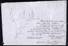
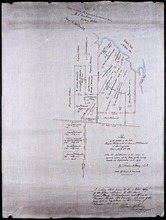
Plan of the division line between Lots 59 and 61, surveyed under the provisions of the Boundary…
Description: Plan of the division line between Lots 59 and 61, surveyed under the provisions of the Boundary Bill 4 William 4 Cap.15. This copy is taken from an original plan created 15 August 1838 by surveyor… more
Province: Prince Edward Island
Type: cadastral maps
Date Created: 1838-08-15
Date Modified: 1908-02
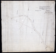
Plan shewing the situation of a new line of road from Baldwin's Road, Lot 51 to Brother's…
Description: Plan showing the situation of a new line of road from Baldwin's Road, Lot 51 to Brother's Road, Lot 66 more
Province: Prince Edward Island
Type: cadastral maps
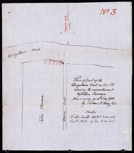
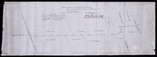
Plan of part of the Georgetown Road on Lot 51 showing the encrouchment by John Curran from a survey…
Description: Plan of part of the Georgetown Road on Lot 51. Shows Union Road and property of John Curran. (No.3) The map shows lots, resident, and roads.
Province: Prince Edward Island
Type: cadastral maps
Date Created: 1908-06-04
Plan of proposed new road straightening Rollo Bay Road, through the farms of Chas. Townshend and…
Description: Plan of proposed new road straightening Rollo Bay Road, through the farms of Chas. Townshend and Jos. Webster. The map shows lots, residents, and roads.
Province: Prince Edward Island
Type: cadastral maps
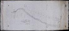
Plan of New Line Road From Montague Bridge tp Keith's Mill on Lots No. 51 & 52: Kings…
Description: Plan of a new line of road from Montague Bridge to Keith's Mill on Lots 51 and 52. As ordered by Jas. E. McDonald, late C.P.W. The map shows lots, residents, roads, and bodies of water such as… more
Province: Prince Edward Island
Type: cadastral maps
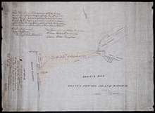
Plan of Shore and Land connected with The Beach Fishery Station Murray Harbour: The Property of Hon…
Description: Plan of part of Lot 64. The shore and land connected with the Beach Fishery Station, Murray Harbour. The property of the Hon. David Davies. The map shows lots, residents, bodies of water, and roads.
Province: Prince Edward Island
Type: cadastral maps
Date Created: 1872-10-29
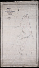
A Plan of Souris Beach
Description: Plan of part of Lots 44 and 45, Souris Beach. The map shows dry spots at low water, lots, and residents.
Province: Prince Edward Island
Type: cadastral maps
Date Created: 1866

Proposed New Road from Chapel Road: To Road leading to Grand River Beach Road
Description: Plan of proposed New Road from Chapel Road to road leading to Grand River Beach Road. Total distance 2.16 miles. (No.47) The map shows residents, lots, roads, and foliage.
Province: Prince Edward Island
Type: cadastral maps
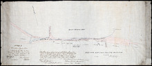
Prince Edward Island Railway
Description: Prince Edward Island Railway. Land appropriated at Souris. This plan shewing the lands appropriated by the Railway Commissioners is filed in the Office of Registar of Deeds and Keeper of Plans for… more
Province: Prince Edward Island
Type: cadastral maps
Date Created: 1874
Plan showing land at Souris appropriated for the Railway : Plan signed by O. Curtis, Registrar of…
Description: Plan showing land at Souris appropriated for the Railway. Plan signed by O. Curtis, Registrar of Deeds. Shown are residents, and railroad tracks.
Province: Prince Edward Island
Type: cadastral maps
Date Created: 1879-06-18

Prince Edward Island Railway Murray Harbour Branch: Plan of extension from Murray River to Murray…
Description: Prince Edward Island Railway. Murray Harbour Branch. Plan of extension from Murray River to Murray Harbour. Produced by Wm. B. MacKenzie, Chief Engineer. The map shows lots, residents, acreage and… more
Province: Prince Edward Island
Type: cadastral maps
Date Created: 1906-05-31
This Plan shewong the land appropriated by the Railway Commissioners is filed in th Office of the…
Description: Prince Edward Island Railway. Railway appropriation at St. Peter's Bay. (No.5) (Also, No. 238A). The map shows lots, roads, residents, and St. Peter's Bay. more
Province: Prince Edward Island
Type: cadastral maps
Date Created: 1874
Plan of Lot 47
Description: Plan of Lot 47 (No. 127). Stewart and Cunard Estates. The map shows Lot 47 divided into parcels of land with the names of residents, acreage amounts and land conveyance references. Some areas of the… more
Province: Prince Edward Island
Type: cadastral maps
Part of Lot 38
Description: The map, drawn in pencil, shows four numbered parcels of land on or near Savage Harbour in the northern portion of Lot 38. It includes names of residents and land conveyance references. At least… more
Province: Prince Edward Island
Type: cadastral maps

Tracing of the right of way for the Prince Edward Island Railway into Georgetown.
Description: Tracing of the right of way for the Prince Edward Island Railway into Georgetown.
Province: Prince Edward Island
Type: cadastral maps

This Plan shewing the lands appropriated by the Railway Commisioners is filed with the Office of…
Description: Prince Edward Island Railway. Plan shows land appropriated by the Railway Commissioners on Lot 45. (No.235C). The map shows residents, acreage, roads, and a church.
Province: Prince Edward Island
Type: cadastral maps