
Prince Edward Island Nova Scotia and New Brunswick: Prince, Queens and Kings Counties, P.E.I.…
Description: Prince, Queens and Kings Counties, Prince Edward Island, portions of New Brunswick, Nova Scotia, and Magdalen Islands. It marks counties, parishes, cities, towns, and villages, beaches, marshes, Lots… more
Publisher: Hydrographic and Map Service, Labelle Building
Province: Prince Edward Island, Nova Scotia, New Brunswick, Quebec
Type: cadastral maps
Date Created: 1940

Plan de l'Ȋle de St. Jean au Nord de l'Acadie et dans le Sud du Golfe de St. Laurent.:…
Description: Plan de l'Ȋle de St. Jean. Par Ordre de M. de Sartine, Conseiller d'Etat, Ministre et Secretaire d'Etat au Département de la Marine. The map shows the province of Prince Edward Island… more
Publisher: Sartine, M. de
Province: Prince Edward Island
Type: topographic maps
Date Created: 1778

Map of Prince Edward Island in the Gulf of St. Lawrence: for McGregor's British America
Publisher: Ballantyne and Company
Province: Prince Edward Island
Type: cadastral maps, topographic maps
Date Created: 1832

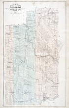
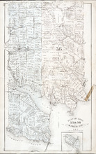
Plan of Lot Thirty Seven : Plan of Lot Thirty Eight: Queens Co., P.E.I.. Kings Co., P.E.I.
Description: The map shows lot 37 (coloured in pink) in Queens county, and lot 38 (coloured in blue) in Kings county. Shown are roads, railroads, landowners and acreage, rivers, ponds, harbours, gulfs, creeks,… more
Publisher: J. H. Meacham & company
Province: Prince Edward Island
Type: cadastral maps
Date Issued (Source): 1880
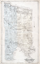
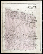
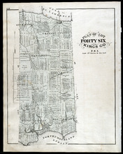
Plan of Lots Fourty Three & Fourty Four: Kings Co., P.E.I.
Description: The map shows lots 43 & 44 in Kings county. Shown are bays, gulfs, rivers, coves, capes, roads, railroads and stations, landowners and acreage, crosses, post offices, churches, and factories.… more
Publisher: J. H. Meacham & company
Province: Prince Edward Island
Type: cadastral maps
Date Issued (Source): 1880
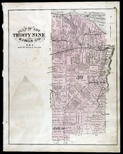
Plan of Lot Thirty Nine: Kings Co., P.E.I.
Description: The map shows lot 39 in Kings county. Shown are a gulf, lake, sand, light house, post offices, landowners and acreage, roads, railroads and stations, rivers, school houses, churches, and an Indian… more
Publisher: J. H. Meacham & company
Province: Prince Edward Island
Type: cadastral maps
Date Issued (Source): 1880
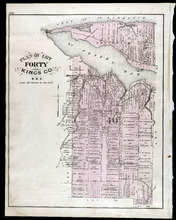
Plan of Lot Fourty: Kings Co., P.E.I.
Description: The map shows Lot 40 in Kings county. Shown are a bay, gulf, river, ponds, school house, churches, wharf, post office, roads, landowners and acreage, and mills. Compass.
Publisher: J. H. Meacham & company
Province: Prince Edward Island
Type: cadastral maps
Date Issued (Source): 1880
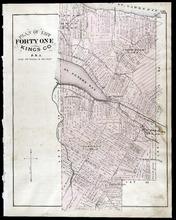
Plan of Lot Forty One: Kings Co., P.E.I.
Description: The map shows lot 41 in Kings county. Shown are St. Peters bay, river, gulf, roads, landowners and acreage, railroad and station, post offices, mills, schools, and churches. Compass.
Publisher: J. H. Meacham & company
Province: Prince Edward Island
Type: cadastral maps
Date Issued (Source): 1880
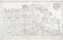
Plan of Lots 51, 52, & 66: Kings Co., P.E.I.
Description: The map shows lots 51, 52, & 66 in Kings county. Shown are roads, railroads and stations, landowners and acreage, streams, rivers, post offices, mills, and churches. Graphic compass.
Publisher: J. H. Meacham & company
Province: Prince Edward Island
Type: cadastral maps
Date Issued (Source): 1880
Plan of Lot Forty Two: Kings Co., P.E.I.
Description: The map shows lot 42 in Kings county. Shown are a gulf, marsh, roads, railroad and stations, post offices, school houses, rivers, and a brook. Compass.
Publisher: J. H. Meacham & company
Province: Prince Edward Island
Type: cadastral maps
Date Issued (Source): 1880
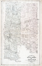
Plan of Lots Fifty Three & Fifty Four: Kings Co., P.E.I.
Description: The map shows lots 53 & 54 in Kings county. Shown are roads, railroads and stations, landowners and acreage, rivers, creeks, wharfs, post offices, and mills. Graphic compass.
Publisher: J. H. Meacham & company
Province: Prince Edward Island
Type: cadastral maps
Date Issued (Source): 1880
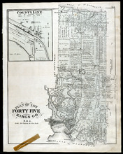
Plan of Lot Fourty Five: Kings Co., P.E.I.
Description: The map shows Lot 45 in Kings county. Shown are the gulf, bay, rivers, coves, post offices, cross, mills, roads, railroad, landowners and acreage, churches, hospital, harbour, and sand. Compass.
Publisher: J. H. Meacham & company
Province: Prince Edward Island
Type: cadastral maps
Date Issued (Source): 1880
Plan of Lots 55 & 56: Kings Co., P.E.I.
Description: The map shows lots 55 & 56 in Kings county. Shown are roads, landowners and acreage, crosses, rivers, ponds, creeks, bays, coves, sand, wharfs, mills, post offices, churches, schools, and… more
Publisher: J. H. Meacham & company
Province: Prince Edward Island
Type: cadastral maps
Date Issued (Source): 1880
Plan of Lot Fourty Six: Kings Co., P.E.I.
Description: The map shows lot 46 in Kings county. Shown are a gulf, straits, pond, roads, landowners and acreage, school houses, post offices, mills, and sand. Compass.
Publisher: J. H. Meacham & company
Province: Prince Edward Island
Type: cadastral maps
Date Issued (Source): 1880
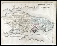
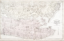
Georgetown Royalty and Reserve Land: Kings Co., P.E.I.
Description: The map shows Georgetown Royalty and Reserve Land in Kings county. Shown are rivers, roads, railroads and stations, landowners and acreage, beaches, Georgetown commons, square, market, court house,… more
Publisher: J. H. Meacham & company
Province: Prince Edward Island
Type: cadastral maps
Date Issued (Source): 1880
Plan of Lots 59 & 61: Kings Co., P.E.I.
Description: The map shows lots 59 & 61 in Kings county. Shown are roads, landowners and acreage, crosses, rivers, ponds, creeks, bays, coves, sand, wharfs, mills, post offices, churches, schools, light… more
Publisher: J. H. Meacham & company
Province: Prince Edward Island
Type: cadastral maps
Date Issued (Source): 1880
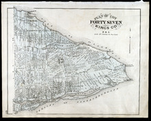
Plan of Lot Forty Seven: Kings Co., P.E.I.
Description: The map shows Lot 47 in Kings county. Shown are a gulf, straits, rivers, lakes, swamp, sand, fishing huts, mills, post offices, churches, creeks, light house, and pond. Compass.
Publisher: J. H. Meacham & company
Province: Prince Edward Island
Type: cadastral maps
Date Issued (Source): 1880
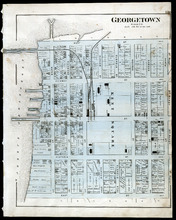
Georgetown: Kings Co., P.E.I.
Description: The map shows Georgetown in Kings county. Shown are wharfs, harbour, roads and streets, railroads and stations, landowners, houses, court house, scholl house, drill shed, Georgetown square, churches… more
Publisher: J. H. Meacham & company
Province: Prince Edward Island
Type: cadastral maps
Date Issued (Source): 1880
Plan of Lots 63 & 64: Kings Co., P.E.I.
Description: The map shows Lots 63 & 64 in Kings county. Shown are roads, landowners and acreage, crosses, rivers, straits, ponds, gulfs, marshes, coves, wharfs, post offices, mills, churches, factories, and… more
Publisher: J. H. Meacham & company
Province: Prince Edward Island
Type: cadastral maps
Date Issued (Source): 1880
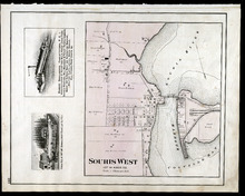
Souris West Lot 44: Kings Co., P.E.I.
Description: The map shows Lot 44 in Souris West, Kings county. Shown are a bay, harbour, river, railroad, landowners, roads, houses and buildings, school houses, businesses, and shipyards. Compass.
Publisher: J. H. Meacham & company
Province: Prince Edward Island
Type: cadastral maps
Date Issued: 1880
Date Issued (Source): 1880
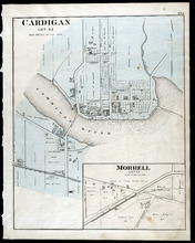
Cardigan Lot 53: Morrell Lot 40
Description: The map shows lot 53 in Cardigan. Shown are a river, roads, railroads, lots, landowners, school house, buildings, houses, wharfs and creeks. Compass.
Publisher: J. H. Meacham & company
Province: Prince Edward Island
Type: cadastral maps
Date Issued (Source): 1880

Montague Bridge Lots 59 & 52: Kings Co., P.E.I.
Description: The map shows lots 59 & 52 in Montague Bridge, Kings county. Shown are rivers, wharfs, shipyards, roads, landowners and acreage, halls, churches, buildings and businesses. Compass.
Publisher: J. H. Meacham & company
Province: Prince Edward Island
Type: cadastral maps
Date Issued (Source): 1880
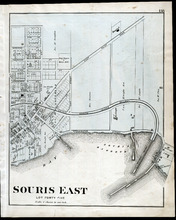
Souris East: Lot Forty Five
Description: The map shows Lot 45 in Souris East. Shown are the Souris Harbour and Bay, wharfs, roads and streets, railroads, lobster factory, landowners, houses, buildings and businesses. Compass
Publisher: J. H. Meacham & company
Province: Prince Edward Island
Type: cadastral maps
Date Issued (Source): 1880