Displaying 1 - 7 of 7

Plan of Township No 63 St. Andrew's Parish Queens County: P.E.Island
Description: Plan of Lot 63. This is one of the plans referred to in the Deed from the Cunards to the Commissioner of Public Lands, July 15, 1866. The map shows lots, residents, roads, acreage and bodies of water… more
Province: Prince Edward Island
Type: cadastral maps
Date Created: 1851
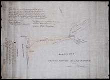
Prince Edward Island Railway
Description: Prince Edward Island Railway. Land appropriated at Souris. This plan shewing the lands appropriated by the Railway Commissioners is filed in the Office of Registar of Deeds and Keeper of Plans for… more
Province: Prince Edward Island
Type: cadastral maps
Date Created: 1874
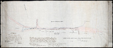
This Plan shewong the land appropriated by the Railway Commissioners is filed in th Office of the…
Description: Prince Edward Island Railway. Railway appropriation at St. Peter's Bay. (No.5) (Also, No. 238A). The map shows lots, roads, residents, and St. Peter's Bay. more
Province: Prince Edward Island
Type: cadastral maps
Date Created: 1874

Plan of Township No. 64: St. Andrews Parish, Queens County, P. E. Island
Description: Lot 64 is situated in Kings County, not Queens County as stated in the map title. The map shows Lot 64 divided into parcels of land with names of residents and their acreage amounts. Several parcels… more
Province: Prince Edward Island
Type: cadastral maps
Date Created: 1850

Plan of the Eastern Moiety of Township No. 46 East Parish. Kings County. P. E. Island.
Description: Plan of the eastern moiety of Lot 46, East Parish, Kings Co. (No.125). Cunard Estate. Shows names of residents and acreage, roads, and the Gulf of St. Lawrence. One of the plans referred to in the… more
Province: Prince Edward Island
Type: cadastral maps
Date Created: 1866

A Plan of the Eastern Moiety of Township No. 46 From the Survey of H. J. Cundall L. S. By Owen…
Description: Plan of the eastern half of Lot 46. (No.126) created by Owen Curtis and R.A. Strong from the survey by H.J. Cundall. Shows names of residents, acreage, and land conveyance references, bodies of water… more
Province: Prince Edward Island
Type: cadastral maps

Plan of the Northern Moiety of Lot 45: compiled from surveys made by L.N. Gall and H.J. Cundall.
Description: Plan of the northern moiety of Lot 45 compiled from surveys made by L.N. Gall and H.J. Cundall. Plan referred to in deed to Commissioner of Public Land, dated 13th July, 1866. The map of the northern… more
Province: Prince Edward Island
Type: cadastral maps
Date Created: 1866