Displaying 1 - 12 of 12

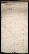
Plan of a Line of Road from Montague River Bridge to Wood Islands: Run in November 1833
Description: Plan of a line of road from Montague River Bridge to Wood Islands. Passes through Lots 59, 60, 61, and 62. (No.59). Shown are residents, lots, and rivers.
Province: Prince Edward Island
Type: cadastral maps
Date Created: 1833-11
A Plan of the North or C Division of Lot or Township No. 59: Kings County, P. E. Island
Description: A plan of the north division of Lot 59 (No.159). James Montgomery Estate. The map shows the C Division of Lot 59 divided into numbered parcels of land with the names of occupants and their… more
Province: Prince Edward Island
Type: cadastral maps
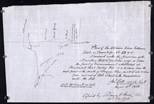
Plan of the division line between Lots 59 and 61, surveyed under the provisions of the Boundary…
Description: Plan of the division line between Lots 59 and 61, surveyed under the provisions of the Boundary Bill 4 William 4 Cap.15. This copy is taken from an original plan created 15 August 1838 by surveyor… more
Province: Prince Edward Island
Type: cadastral maps
Date Created: 1838-08-15
Date Modified: 1908-02

Plan of Lot 59 (No.156)
Description: Plan of Lot 59 (No.156). Montgomery Estate. Shows names, acreage, and land conveyance references for some residents, roads, and a nautical compass.
Province: Prince Edward Island
Type: cadastral maps

A Plan of the undisposed part of 1/3 of Lot No. 59 Kings County in Prince Edward Island belonging…
Description: A plan of the undisposed part of Lot 59 belonging to the Earl of Selkirk (No.158). Shows names of residents, acreage, and land conveyance references. Surveyed by Rod'k Campbell.The map shows… more
Province: Prince Edward Island
Type: cadastral maps
Plan of Township No. 59: Compiled from the proprietors plans, descriptions in leases and registered…
Description: Plan of Lot 59 compiled from the proprietors' plans, descriptions in leases and registered deeds, and from Meacham's Atlas with additions and corrections from surveys made at various times… more
Province: Prince Edward Island
Type: cadastral maps
Date Created: 1922-03
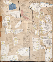
Montague Bridge P.E.I.
Description: This is a fire insurance plan of the village of Montague Bridge consisting of two (2) maps--one for each side of the Montague River. It was created in 1888 and revised to 1910. The map on the left… more
Publisher: Chas. E. Goad, Civil Engineer
Province: Prince Edward Island
Type: fire insurance maps
Date Created: 1888-10
Date Modified: 1910-09
Date Issued (Source): 1888
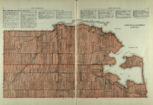
Lots 59 and 61: Kings County
Description: The map shows lots 59 and 61 in Kings county. Shown are Montague river, bays, points, coves, landowners, acreage, roads, creeks, and Panamure Island.
Publisher: Cummins Map Co.
Province: Prince Edward Island
Type: cadastral maps
Date Issued (Source): 1927
Rural Directory - Lots 59 and 61, Kings County
Description: A directory listing of residents of lots 59 and 61.
Publisher: Cummins Map Co.
Province: Prince Edward Island
Type: text
Date Issued (Source): 1927
Rural Directory - Lots 59, 61, 63, and 64, Kings County
Description: A directory listing of residents of lots 59 , 61, 63, and 64
Publisher: Cummins Map Co.
Province: Prince Edward Island
Type: text
Date Issued (Source): 1927
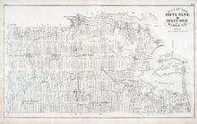
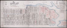
Plan of Lots 59 & 61: Kings Co., P.E.I.
Description: The map shows lots 59 & 61 in Kings county. Shown are roads, landowners and acreage, crosses, rivers, ponds, creeks, bays, coves, sand, wharfs, mills, post offices, churches, schools, light… more
Publisher: J. H. Meacham & company
Province: Prince Edward Island
Type: cadastral maps
Date Issued (Source): 1880

Montague Bridge Lots 59 & 52: Kings Co., P.E.I.
Description: The map shows lots 59 & 52 in Montague Bridge, Kings county. Shown are rivers, wharfs, shipyards, roads, landowners and acreage, halls, churches, buildings and businesses. Compass.
Publisher: J. H. Meacham & company
Province: Prince Edward Island
Type: cadastral maps
Date Issued (Source): 1880