Displaying 757 - 845 of 845
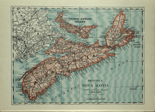
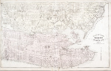
Province of Novia Scotia and Prince Edward Island Canada
Description: The map shows the Provinces of Novia Scotia and Prince Edward Island Canada. Shown are Cape Breton Island, New Brunswick, Atlantic Ocean, Sable Island, Northumberland Strait, Bay of Fundy, roads,… more
Publisher: Cummins Map Co.
Province: Nova Scotia, Prince Edward Island, Cape Breton Island, New Brunswick
Type: cadastral maps
Date Issued (Source): 1927
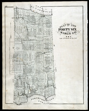
Plan of Lots 55 & 56: Kings Co., P.E.I.
Description: The map shows lots 55 & 56 in Kings county. Shown are roads, landowners and acreage, crosses, rivers, ponds, creeks, bays, coves, sand, wharfs, mills, post offices, churches, schools, and… more
Publisher: J. H. Meacham & company
Province: Prince Edward Island
Type: cadastral maps
Date Issued (Source): 1880
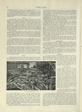
Nova Scotia - 2
Description: Text provides information of the different industries of Nova Scotia such as mining, coal, foresty and agriculture
Publisher: Cummins Map Co.
Province: Nova Scotia
Type: text
Date Issued (Source): 1927
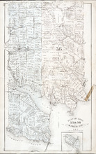
Plan of Lot Fourty Six: Kings Co., P.E.I.
Description: The map shows lot 46 in Kings county. Shown are a gulf, straits, pond, roads, landowners and acreage, school houses, post offices, mills, and sand. Compass.
Publisher: J. H. Meacham & company
Province: Prince Edward Island
Type: cadastral maps
Date Issued (Source): 1880
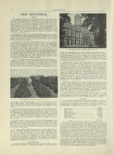
New Brunswick - 1
Description: Text provides information of history, government, and agriculture of New Brunswick.
Publisher: Cummins Map Co.
Province: New Brunswick
Type: text
Date Issued (Source): 1927
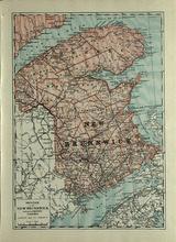
Province of New Brunswick and part of Quebec, Canada
Description: The map shows the Provinces of New Brunswick and part of Quebec, Canada. Shown are Prince Edward Island, United States, Nova Scotia, St. Lawrence River and Gulf, Northumberland Strait, Bay of Fundy,… more
Publisher: Cummins Map Co.
Province: Nova Scotia, Prince Edward Island, Quebec, New Brunswick
Type: cadastral maps
Date Issued (Source): 1927
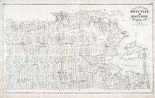
Plan of Lots Fifty Seven & Fifty Eight: Queens Co., P.E.I.
Description: The map shows lots 57 & 58 in Queens county. Includes an inset map of Prim Island / Point Prim. Shown are roads, landowners and acreage, crosses, rivers, ponds, creeks, bays, coves, sand, wharfs… more
Publisher: J. H. Meacham & company
Province: Prince Edward Island
Type: cadastral maps
Date Issued (Source): 1880
New Brunswick - 2
Description: Text provides information of Farming and Forestry in New Brunswick
Publisher: Cummins Map Co.
Province: New Brunswick
Type: text
Date Issued (Source): 1927
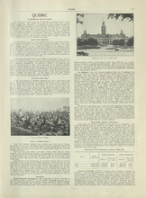
Quebec - 1
Description: Text provides information of history, population, and farming industry of Quebec
Publisher: Cummins Map Co.
Province: Quebec
Type: text
Date Issued (Source): 1927
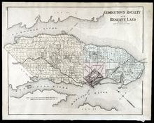
Georgetown Royalty and Reserve Land: Kings Co., P.E.I.
Description: The map shows Georgetown Royalty and Reserve Land in Kings county. Shown are rivers, roads, railroads and stations, landowners and acreage, beaches, Georgetown commons, square, market, court house,… more
Publisher: J. H. Meacham & company
Province: Prince Edward Island
Type: cadastral maps
Date Issued (Source): 1880
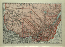
Province of Quebec, Canada
Description: The map shows the province of Quebec in Canada. Shown are Ontario, New York, Maine, towns, cities, raods, railroads, and St. Lawrence River.
Publisher: Cummins Map Co.
Province: Quebec
Type: cadastral maps
Date Issued (Source): 1927
Plan of Lots 59 & 61: Kings Co., P.E.I.
Description: The map shows lots 59 & 61 in Kings county. Shown are roads, landowners and acreage, crosses, rivers, ponds, creeks, bays, coves, sand, wharfs, mills, post offices, churches, schools, light… more
Publisher: J. H. Meacham & company
Province: Prince Edward Island
Type: cadastral maps
Date Issued (Source): 1880
Quebec - 2
Description: Text provides information of the farming industry of Quebec
Publisher: Cummins Map Co.
Province: Quebec
Type: text
Date Issued (Source): 1927
Plan of Lot Forty Seven: Kings Co., P.E.I.
Description: The map shows Lot 47 in Kings county. Shown are a gulf, straits, rivers, lakes, swamp, sand, fishing huts, mills, post offices, churches, creeks, light house, and pond. Compass.
Publisher: J. H. Meacham & company
Province: Prince Edward Island
Type: cadastral maps
Date Issued (Source): 1880
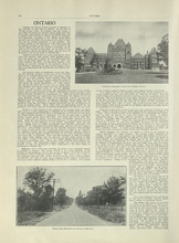
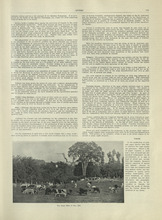
Ontario - 1
Description: Text provides information on the history and farming industries of Ontario
Publisher: Cummins Map Co.
Province: Ontario
Type: text
Date Issued (Source): 1927
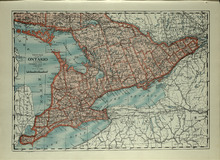
Province of Ontario, Canada
Description: The map shows the Province of Ontario, Canada. Shown are Georgian Bay, Lake Ontario, Erie, and Huron, Michigan, New York, roads, towns and cities.
Publisher: Cummins Map Co.
Province: Ontario
Type: cadastral maps
Date Issued (Source): 1927
Plan of Lot Sixty & Sixty Two: Queens Co., P.E.I.
Description: The map shows lots 60 & 62 in Queens county. Shown are roads, landowners and acreage, rivers, straits, ponds, bays, creeks, sand, post offices, mills, churches, and school houses. Graphic compass.
Publisher: J. H. Meacham & company
Province: Prince Edward Island
Type: cadastral maps
Date Issued (Source): 1880

Ontario - 2
Description: Text provides information of the farming and other industries of Ontario
Publisher: Cummins Map Co.
Province: Ontario
Type: text
Date Issued (Source): 1927
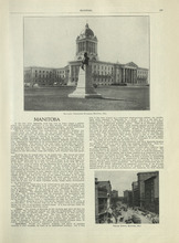
Manitoba - 1
Description: Text provides information of history, climate, and farming in Manitoba.
Publisher: Cummins Map Co.
Province: Manitoba
Type: text
Date Issued (Source): 1927
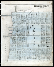
Georgetown: Kings Co., P.E.I.
Description: The map shows Georgetown in Kings county. Shown are wharfs, harbour, roads and streets, railroads and stations, landowners, houses, court house, scholl house, drill shed, Georgetown square, churches… more
Publisher: J. H. Meacham & company
Province: Prince Edward Island
Type: cadastral maps
Date Issued (Source): 1880
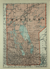
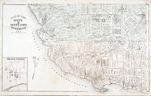
Province of Manitoba, Canada
Description: The map shows the province of Manitoba, Canada. Shown are the lakes, rivers and other bodies of water, and railroads.
Publisher: Cummins Map Co.
Province: Manitoba, Saskatchewan, Ontario
Type: cadastral maps
Date Issued (Source): 1927
Plan of Lots 63 & 64: Kings Co., P.E.I.
Description: The map shows Lots 63 & 64 in Kings county. Shown are roads, landowners and acreage, crosses, rivers, straits, ponds, gulfs, marshes, coves, wharfs, post offices, mills, churches, factories, and… more
Publisher: J. H. Meacham & company
Province: Prince Edward Island
Type: cadastral maps
Date Issued (Source): 1880
Manitoba - 2
Description: Text provides information of the landscape, industries, and government of Manitoba
Publisher: Cummins Map Co.
Province: Manitoba
Type: text
Date Issued (Source): 1927
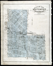
Plan of Lot Sixty Seven: Queens Co., P.E.I.
Description: The map shows Lot 67 in Queens county. Shown are roads, landowners and acreage, railroads and stations, post offices, church, and school houses. Compass.
Publisher: J. H. Meacham & company
Province: Prince Edward Island
Type: cadastral maps
Date Issued (Source): 1880
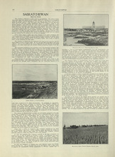
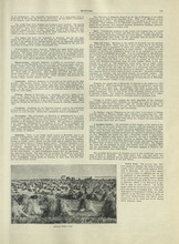
Saskatchewan - 1
Description: Text provides information of the history, government, and landscape of Saskatchewan
Publisher: Cummins Map Co.
Province: Saskatchewan
Type: text
Date Issued (Source): 1927
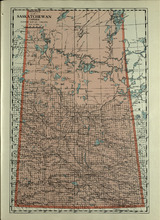
Province of Saskatchewan, Canada
Description: The map shows the province of Saskatchewan, Canada. Shown are rivers, lakes, and other bodies of water, roads, and railroads.
Publisher: Cummins Map Co.
Province: Saskatchewan, Alberta, Mantitoba
Type: cadastral maps
Date Issued (Source): 1927
Plan of Lot 65 : Queens Co., P.E.I.
Description: The map shows Lot 65 in Queens county. Shown are roads, landowners and acreage, creeks, rivers, straits, marshes, brooks, coves, sand, reef, fishing stage, wharfs, post offices, mills, churches,… more
Publisher: J. H. Meacham & company
Province: Prince Edward Island
Type: cadastral maps
Date Issued (Source): 1880
Saskatchewan - 2
Description: Text provides information of population, land, climate, and farming in Saskatchewan
Publisher: Cummins Map Co.
Province: Saskatchewan
Type: text
Date Issued (Source): 1927
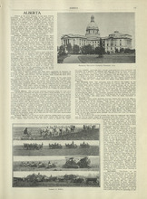
Alberta - 1
Description: Text provides information of different regions of Alberta, their history, and agriculture in Alberta
Publisher: Cummins Map Co.
Province: Alberta
Type: text
Date Issued (Source): 1927
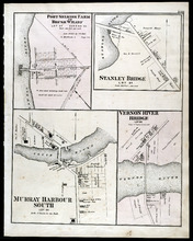
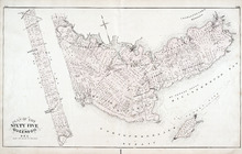
Port Selkirk Farm or Brush Wharf, Stanley Bridge: Murray Harbour South, and Vernon River Bridge
Description: The map shows Port Selkirk Farm or Brush Wharf lot 57 in Queens county. Shown are a river, wharf, road and street, landowners, and measurements. Compass.
Publisher: J. H. Meacham & company
Province: Prince Edward Island
Type: cadastral maps
Date Issued (Source): 1880
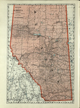
Province of Alberta, Canada
Description: The map shows the province of Alberta, Canada. Shown are bodies of water, rivers, lakes, etc., cities and towns, roads and railroads.
Publisher: Cummins Map Co.
Province: Alberta, British Columbia, Saskatchewan
Type: cadastral maps
Date Issued (Source): 1927
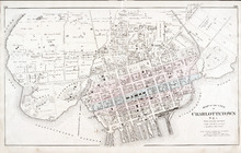
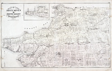
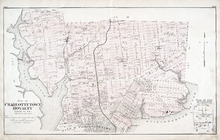
Map of the City of Charlottetown
Description: The map shows the city of Charlottetown. Shown are the wards, roads, landowners and acreage, asylums, ponds, rivers, houses, cemetery, estates, churches, lakes, parks, wharfs, and Charlottetown… more
Publisher: J. H. Meacham & company
Province: Prince Edward Island
Type: cadastral maps
Date Issued (Source): 1880
Alberta - 2
Description: Text provides information of different industries in Alberta, and the population in Alberta
Publisher: Cummins Map Co.
Province: Alberta
Type: text
Date Issued (Source): 1927
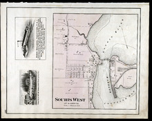
Souris West Lot 44: Kings Co., P.E.I.
Description: The map shows Lot 44 in Souris West, Kings county. Shown are a bay, harbour, river, railroad, landowners, roads, houses and buildings, school houses, businesses, and shipyards. Compass.
Publisher: J. H. Meacham & company
Province: Prince Edward Island
Type: cadastral maps
Date Issued: 1880
Date Issued (Source): 1880
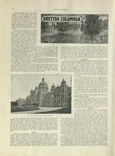
British Columbia - 1
Description: Text provides information of history, climate, lumbering, and agriculture in British Columbia
Publisher: Cummins Map Co.
Province: British Columbia
Type: text
Date Issued (Source): 1927
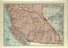
Province of British Columbia, Canada
Description: The map shows the province of British Columbia, Canada. Shown are the Pacific Ocean, Rocky Mountains, Vancouver Island, mountains, roads, and railroads.
Publisher: Cummins Map Co.
Province: British Columbia, Alberta
Type: cadastral maps
Date Issued (Source): 1927
Plan of Charlottetown Royalty: Queens Co., P.E.I.
Description: The map shows the city of Charlottetown and a plan for lots. Shown are rivers, creeks, roads, railroad and stations, landowners and acreage, mills, park, bridge, college, farms, asylums, and a… more
Publisher: J. H. Meacham & company
Province: Prince Edward Island
Type: cadastral maps
Date Issued (Source): 1880
British Columbia - 2
Description: Text provides information of the population and the various industries in British Columbia, such as mining, fishing, manufacturing, and transportation.
Publisher: Cummins Map Co.
Province: British Columbia
Type: text
Date Issued (Source): 1927
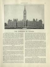
The Dominion of Canada - 1
Description: Text provides information of the history of Canada as a dominion and the establishment of the provinces and territories.
Publisher: Cummins Map Co.
Type: text
Date Issued (Source): 1927
The Dominion of Canada - 2
Description: Text provides information of the physical features of the land dividing each provinces and territories, and the industries that belong to each province and territory
Publisher: Cummins Map Co.
Province: Yukon, Northwest Territories
Type: text
Date Issued (Source): 1927
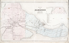
Map of Alberton Lots 4 & 5: Prince Co., P.E.I.
Description: The map shows lots 4 & 5 in the town of Alberton, Prince county. Shown are rivers, creeks, lakes, wharfs, shipyard, roads, railroad, landowners and acreage, mills, churches and cemetery. Compass… more
Publisher: J. H. Meacham & company
Province: Prince Edward Island
Type: cadastral maps
Date Issued (Source): 1880
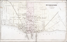
Summerside: Prince Co.
Description: The map shows the city of Summerside. Shown are the wards, roads, landowners and acreage, harbour, barracks, schools, squares, shipyards, railroad and station, and wharfs. Compass.
Publisher: J. H. Meacham & company
Province: Prince Edward Island
Type: cadastral maps
Date Issued (Source): 1880
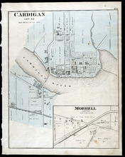
Cardigan Lot 53: Morrell Lot 40
Description: The map shows lot 53 in Cardigan. Shown are a river, roads, railroads, lots, landowners, school house, buildings, houses, wharfs and creeks. Compass.
Publisher: J. H. Meacham & company
Province: Prince Edward Island
Type: cadastral maps
Date Issued (Source): 1880

Montague Bridge Lots 59 & 52: Kings Co., P.E.I.
Description: The map shows lots 59 & 52 in Montague Bridge, Kings county. Shown are rivers, wharfs, shipyards, roads, landowners and acreage, halls, churches, buildings and businesses. Compass.
Publisher: J. H. Meacham & company
Province: Prince Edward Island
Type: cadastral maps
Date Issued (Source): 1880
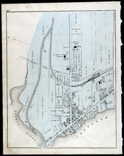
Souris
Description: The map shows a part of Souris. Shown are the Souris river, sand beach, roads, railroads, churhces, landowners, houses, buildings and businesses. Compass
Publisher: J. H. Meacham & company
Province: Prince Edward Island
Type: cadastral maps
Date Issued (Source): 1880
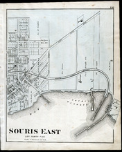
Souris East: Lot Forty Five
Description: The map shows Lot 45 in Souris East. Shown are the Souris Harbour and Bay, wharfs, roads and streets, railroads, lobster factory, landowners, houses, buildings and businesses. Compass
Publisher: J. H. Meacham & company
Province: Prince Edward Island
Type: cadastral maps
Date Issued (Source): 1880
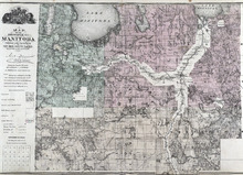
Map of the Province of Manitoba
Description: The map shows the province of Manitoba. Shown on the side are a Reference table and a Township diagram, lakes, roads, marshes, Indian Reserves, churches, rivers, and ponds. Compass.
Publisher: J. H. Meacham & company
Province: Manitoba
Type: cadastral maps
Date Issued (Source): 1880
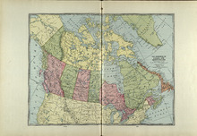
The Dominion of Canada and Newfoundland
Description: The map shows the dominion of Canada and Newfoundland. Shown are all provinces, territories, Greenland, and United States, oceans, bays, and mountains.
Publisher: Cummins Map Co.
Type: cadastral maps
Date Issued (Source): 1927
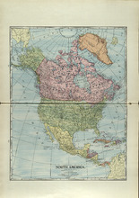
North America
Description: The map shows North America. Shown is the dominion of Canada, United States, Mexico, Central America, bodies of water, and coordinates.
Publisher: Cummins Map Co.
Type: cadastral maps
Date Issued (Source): 1927
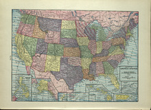
Map of the United States
Description: The map shows the United States. Shown are the Pacific and Atlantic Ocean, dominion of Canada, states, cities and towns.
Publisher: Cummins Map Co.
Type: cadastral maps
Date Issued (Source): 1927
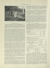
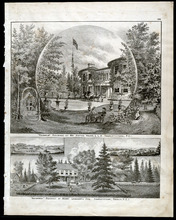
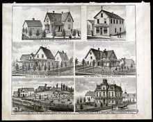
Property Sketches - Page 38
Description: Sketches of locations in Charlottetown and Little York (Lot 34) on Prince Edward Island. Sketches include the residences and property of Hon. W. W. Sullivan, Richard Vessey, Fredk. Hardy, and E. W.… more
Publisher: J. H. Meacham & company
Province: Prince Edward Island
Type: image
Date of Part: 1880
Date Issued (Source): 1880
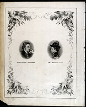
Dedication Page
Description: This page appears after the Table of Contents and contains portraits of the Governor General Marquis of Lorne and Her Royal Highness Princess Louise.
Publisher: J. H. Meacham & company
Province: Prince Edward Island
Type: image
Date Issued (Source): 1880
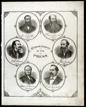
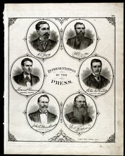
Portraits of Representatives of the Press - Page 22
Description: Sketch of Representatives of the Press including W. L. Cotton (Examiner), Henry Lawson (Patriot), P. R. Bowers (New Era), John Caven (Charlottetown Herald), Rev. Stephen G. Lawson (Presbyterian), and… more
Publisher: J. H. Meacham & company
Province: Prince Edward Island
Type: image
Date Issued (Source): 1880
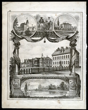
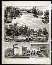
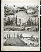
Property Sketches - Page 25
Description: Sketch of various major properties and buildings in Charlottetown, Prince Edward Island including Prince of Wales College, the New Aslyum (Falconwood), Market P.O., Province House, the Court House,… more
Publisher: J. H. Meacham & company
Province: Prince Edward Island
Type: image
Date Issued (Source): 1880
Portraits of Representatives of the Press - Page 26
Description: Sketch of Representatives of the Press including A. L. Graves (Summerside Journal), W. A. Brennan (Summerside Journal), Thomas P. Gorman (Summerside Progress), Peter McCourt (Kings County Advertiser… more
Publisher: J. H. Meacham & company
Province: Prince Edward Island
Type: image
Date Issued (Source): 1880
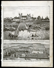
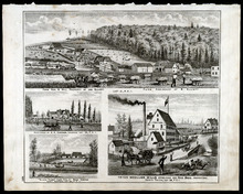
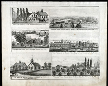
Property Sketches - Page 29
Description: Sketches of locations in and around Charlotteown, Prince Edward Island. Sketches include the residences and property of Benj. E. Wright Esq. (Belmont Farm), McKinnon, Fraser
Publisher: J. H. Meacham & company
Province: Prince Edward Island
Type: image
Date Issued (Source): 1880
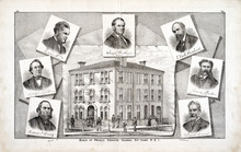
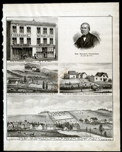
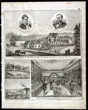
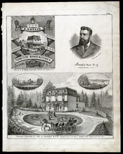
Property Sketches - Page 35
Description: A two page sketch of the Bank of Prince Edward Island in Charlottetown, P.E.I. surrounded by portraits of the Board of Directors (Hon. W. W. Lord, James Peake Esq., Hon. Joseph Hensley, Richard J.… more
Publisher: J. H. Meacham & company
Province: Prince Edward Island
Type: image
Date of Part: 1880
Date Issued (Source): 1880
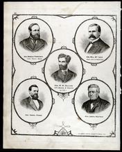
Portraits of Honorable Residents of P.E.I.- Page 41
Description: Sketched portraits of Hon. Donald Ferguson (Com. Public Works), Hon. Neil McLeod (Prov. Secretary and Treasurer), Hon. W. W. Sullivan (Attorney General
Publisher: J. H. Meacham & company
Province: Prince Edward Island
Type: image
Date of Part: 1880
Date Issued (Source): 1880
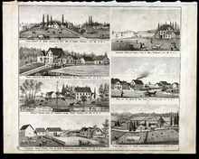
Property Sketches - Page 46
Description: Sketches of the residences and property of Justice Young, L. L. D. (Fairholm, Charlottetown) and Henry Longworth Esq. (Glynwood, Charlottetown) on Prince Edward Island.
Publisher: J. H. Meacham & company
Province: Prince Edward Island
Type: image
Date of Part: 1880
Date Issued (Source): 1880
Property Sketches - Page 49
Description: Sketches of the residences and property of Arthur W. Holroyd Esq. (Wyhther Grange, Charlottetown) and James Dixon Esq. (Lot 33) in Prince Edward Island.
Publisher: J. H. Meacham & company
Province: Prince Edward Island
Type: image
Date of Part: 1880
Date Issued (Source): 1880
Property Sketches - Page 54
Description: Sketches of the residences and property of George Mutch Esq. (Brantford Farm, French Fort, Lot 35) and Abraham Gill Esq. (Little York, Lot 34) in Prince Edward Island.
Publisher: J. H. Meacham & company
Province: Prince Edward Island
Type: image
Date of Part: 1880
Date Issued (Source): 1880
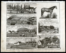
Property Sketches - Page 57
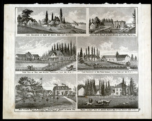
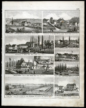
Description: Sketches of various locations across Prince Edward Island including Pownal (Lot 49), Park Corner (Lot 21), West River (Lot 32), Long Creek (Lot 65), Clifton (Lot 21), Clyde River (Lot 31, and Lot 48… more
Publisher: J. H. Meacham & company
Province: Prince Edward Island
Type: image
Date of Part: 1880
Date Issued (Source): 1880
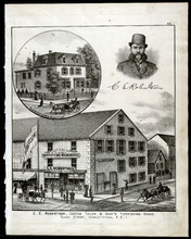
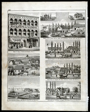
Property Sketches - Page 62
Description: Sketches of C. E. Robertson's business, (Custom Tailor more
Publisher: J. H. Meacham & company
Province: Prince Edward Island
Type: image
Date of Part: 1880
Date Issued (Source): 1880
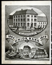
Property Sketches - Page 65
Description: A large sketch of Union Bank (1863-1879) in both Charlottetown (Main Office) and Summerside, Prince Edward Island.
Publisher: J. H. Meacham & company
Province: Prince Edward Island
Type: image
Date of Part: 1880
Date Issued (Source): 1880
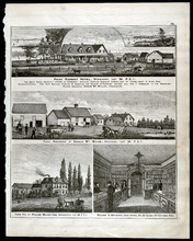
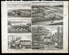
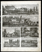
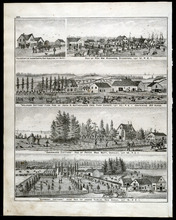
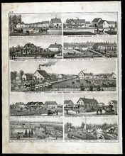
Property Sketches - Page 70
Description: Sketches of various locations across Prince Edward Island including Stanhope (Lot 34), Covehead (Lot 34), Marshfield (Lot 34), and Charlottetown. Sketches include the residences and property of Angus… more
Publisher: J. H. Meacham & company
Province: Prince Edward Island
Type: image
Date Issued (Source): 1880
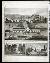
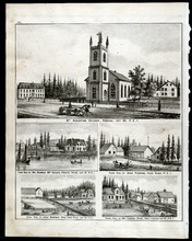
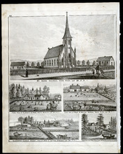
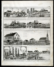
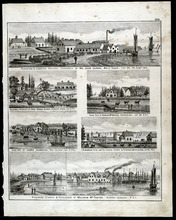
Property Sketches - Page 73
Description: Large sketch of Nova Scotia Forge Co. in New Glasgow, Nova Scotia as well as sketches of the residences and property of Benj. Hughes, Covehead (Lot 34) and David Lawson (Mount Joy Farm), Covehead (… more
Publisher: J. H. Meacham & company
Province: Prince Edward Island
Type: image
Date of Part: 1880
Date Issued (Source): 1880
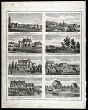
Property Sketches - Page 78
Description: Sketches of various locations across Prince Edward Island including Brackley Point (Lot 33), Covehead (Lot 34), Little York, and Charlottetown (Royalty West). Sketches include the residences and… more
Publisher: J. H. Meacham & company
Province: Prince Edward Island
Type: image
Date of Part: 1880
Date Issued (Source): 1880
Property Sketches - Page 81
Description: Sketches of various locations across Prince Edward Island including Little York (Lot 34), Covehead West (Lot 33), Stanhope (Lot 34), and Charlottetown. Sketches include the residences and property of… more
Publisher: J. H. Meacham & company
Province: Prince Edward Island
Type: image
Date of Part: 1880
Date Issued (Source): 1880
Property Sketches - Page 86
Description: Sketches of various locations across Prince Edward Island including Wheatley River (Lot 24), Greenvale (Lot 23), New Glasgow (Lot 23), and Charlottetown. Sketches include the residences and property… more
Publisher: J. H. Meacham & company
Province: Prince Edward Island
Type: image
Date of Part: 1880
Date Issued (Source): 1880
Property Sketches - Page 89
Description: Sketches of various locations across Prince Edward Island including Rustico (Lot 24), French River (Lot 21), Hope River (Lot 22), and New London (Lot 21). Sketches include the residences and property… more
Publisher: J. H. Meacham & company
Province: Prince Edward Island
Type: image
Date of Part: 1880
Date Issued (Source): 1880
Property Sketches - Page 94
Description: Sketches of various locations across Prince Edward Island including Wheatley River (Lot 24), French River (Lot 21), Seal River (Lot 50), and Charlottetown. Sketches include the residences and… more
Publisher: J. H. Meacham & company
Province: Prince Edward Island
Type: image
Date of Part: 1880
Date Issued (Source): 1880
Property Sketches - Page 97
Description: Sketches of various locations across Prince Edward Island including Hope River (Lot 22), South Rustico (Lot 24), North River (Lot 32), Stanhope (Lot 34) and Hampton (Lot 29). Sketches include the… more
Publisher: J. H. Meacham & company
Province: Prince Edward Island
Type: image
Date of Part: 1880
Date Issued (Source): 1880

Property Sketches - Page 102
Description: Sketches of various locations across Prince Edward Island including Hope River (Lot 22), New London (Lot 21), Vernon River (Lot 49), and Charlottetown. Sketches include the residences and property of… more
Publisher: J. H. Meacham & company
Province: Prince Edward Island
Type: image
Date of Part: 1880
Date Issued (Source): 1880
Property Sketches - Page 105
Publisher: J. H. Meacham & company
Province: Prince Edward Island
Type: image
Date of Part: 1880
Date Issued (Source): 1880
Property Sketches - Page 110
Description: Sketches of various locations across Prince Edward Island including South Wiltshire (Lot 32), Canoe Cove (Lot 65), Bedeque (Lot 26), Crapaud (Lot 29), Loyalist Road (Lot 32), and Elliott River (Lot… more
Publisher: J. H. Meacham & company
Province: Prince Edward Island
Type: image
Date of Part: 1880
Date Issued (Source): 1880
Property Sketches - Page 113
Description: Sketches of various locations across Prince Edward Island including Kelly's Cross (Lot 29), North Bedeque (Lot 25), Crapaud (Lot 29), and Lake Verde (Lot 49). Sketches include the residences and… more
Publisher: J. H. Meacham & company
Province: Prince Edward Island
Type: image
Date of Part: 1880
Date Issued (Source): 1880
Property Sketches - Page 118
Description: Sketches of various locations across Prince Edward Island including properties in Summerside and on Loyalist Road (Lot 32). Sketches include the residences and property of A. L. Graves, S. A. Muncey… more
Publisher: J. H. Meacham & company
Province: Prince Edward Island
Type: image
Date of Part: 1880
Date Issued (Source): 1880
Property Sketches - Page 121
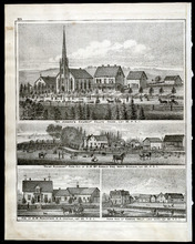
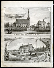
Description: Sketches of various locations across Prince Edward Island including St. Patrick's Church in Fort Augustus (Lot 36) and Lorne Hotel in Tracadie Beach (Lot 35). more
Publisher: J. H. Meacham & company
Province: Prince Edward Island
Type: image
Date of Part: 1880
Date Issued (Source): 1880
Property Sketches - Page 126
Description: Sketches of various locations across Prince Edward Island including Bedeque (Lot 26), Victoria (Lot 29), Lower Freetown (Lot 25), Bunberry (Lot 48), Rustico Beach, and North Wiltshire (Lot 31).… more
Publisher: J. H. Meacham & company
Province: Prince Edward Island
Type: image
Date of Part: 1880
Date Issued (Source): 1880
Property Sketches - Page 129
Description: Sketches of various locations across Prince Edward Island including Crapaud (Lot 29), Lot 21, East Suffolk (Lot 34), and North Tryon (Lot 28). Sketches include the residences and property of Jas.… more
Publisher: J. H. Meacham & company
Province: Prince Edward Island
Type: image
Date of Part: 1880
Date Issued (Source): 1880
Property Sketches - Page 134
Description: Sketches of various locations across Prince Edward Island including Charlottetown, Falconwood Asylum, Hillsborough River, and East River (Lot 34). Sketches include the residences and property of E. D… more
Publisher: J. H. Meacham & company
Province: Prince Edward Island
Type: image
Date of Part: 1880
Date Issued (Source): 1880

Property Sketches - Page 137
Description: Sketches of various locations across Prince Edward Island including New London (Lot 20), St. Eleanors (Lot 17), Hamilton (Lot 18), Long River (Lot 20), Malpeque Road (Lot 18), Brackley Point Road,… more
Publisher: J. H. Meacham & company
Province: Prince Edward Island
Type: image
Date of Part: 1880
Date Issued (Source): 1880
Property Sketches - Page 142
Description: Sketches of various locations across Prince Edward Island including Margate (Lot 19), Lot 12 Point, Darnley (Lot 18), Belmont (Lot 16), St. Eleanors (Lot 17), Grand River (Lot 14), Princetown, and… more
Publisher: J. H. Meacham & company
Province: Prince Edward Island
Type: image
Date of Part: 1880
Date Issued (Source): 1880
Property Sketches - Page 145
Description: Sketches of various locations across Prince Edward Island including Fort Augustus (Lot 36), Biddeford (Lot 12), Park Corner (Lot 20), Darnley (Lot 18), and New Annan (Lot 19). Sketches include the… more
Publisher: J. H. Meacham & company
Province: Prince Edward Island
Type: image
Date of Part: 1880
Date Issued (Source): 1880
Property Sketches - Page 146
Description: Sketches of various locations across Prince Edward Island including New London (Lot 21), West Cape (Lot 7), Port Hill, Long River (Lot 20), Fortune Cove (Lot 5), West Point (Lot 7), Richmond Bay, and… more
Publisher: J. H. Meacham & company
Province: Prince Edward Island
Type: image
Date of Part: 1880
Date Issued (Source): 1880
Property Sketches - Page 149
Description: Sketches of various locations across Prince Edward Island including Wellington (Lot 16), Alberton, West Point (Lot 8), Bloomfield (Lot 5), Ellerslie, and West Devon (Lot 10). Sketches include the… more
Publisher: J. H. Meacham & company
Province: Prince Edward Island
Type: image
Date of Part: 1880
Date Issued (Source): 1880
Property Sketches - Page 150
Publisher: J. H. Meacham & company
Province: Prince Edward Island
Type: image
Date of Part: 1880
Date Issued (Source): 1880
Property Sketches - Page 153 : Property Sketches - Page 153 : Property Sketches - Page 153 :…
Description: Sketches of various locations across Prince Edward Island including Alberton, Cornwall (Lot 32), Biddeford, North River Bridge (Lot 32), St. Eleanors (Lot 17), Wilmot Creek (Lot 19), and Port Hill.… more
Publisher: J. H. Meacham & company
Province: Prince Edward Island
Type: image
Date of Part: 1880
Date Issued (Source): 1880
Property Sketches - Page 159
Description: Sketches of various locations across Prince Edward Island including Georgetown, Miscouche (Lot 17), Murray River (Lot 63), Little Sands (Lot 64), and New Perth (Lot 52). Sketches include the… more
Publisher: J. H. Meacham & company
Province: Prince Edward Island
Type: image
Date Issued (Source): 1880