Displaying 1 - 9 of 9

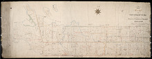
A Plan of Township No 4 Part of the Cunard Estate Prince County P.E.Island
Description: A plan of Lot 4, part of the Cunard Estate. Copied from plans in the Public Lands Department. The map shows lots, residents, bodies of water such as rivers, railways, and roads.
Province: Prince Edward Island
Type: cadastral maps
Date Created: 1885-06

Plan of Cascumpec Point Copied from a Plan in the Public Lands Departt. furnished by John Ball. L.…
Description: Plan of Cascumpec Point, Lot 5. The map shows numbered parcels of land on Cascumpec Point with names of residents and some land conveyance references. The legend indicates that parcels are outlined… more
Province: Prince Edward Island
Type: cadastral maps
Date Created: 1885-06

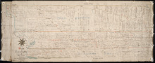
Plan of Township No. 2: Compiled from the Proprietors Plans and partial surveys
Description: Plan of Lot 2 (No.5). Compiled from the Proprietors Plans and partial surveys by John Ball, Public Lands Department. Cunard Estate. Shows the names of residents, former occupants, and land conveyance… more
Province: Prince Edward Island
Type: cadastral maps
Date Created: 1885-10
Plan of Township No. 26: Comprising the Holland, Stephens, and Thomson Estates Copied from the…
Description: Plan of Lot 26 (No.70) comprising the Holland, Stephens, and Thomson Estates copied from the plans in Public Lands Department, corrected by partial surveys and Meacham's Atlas. more
Province: Prince Edward Island
Type: cadastral maps
Date Created: 1885-09
Plan of Township 27: embracing Freeholds and the Pope and Cunard Estates. Compiled from Meacham…
Description: Plan of Lot 27 (No.73) embracing freeholds and the Pope and Cunard Estates. Compiled from Meacham's Atlas and the original leases. more
Province: Prince Edward Island
Type: cadastral maps
Date Created: 1885-09
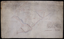
A Map and Survey Of Marshes east of Mount Stewart Bridge on the north side of Hillsborough River in…
Description: A map and survey of marshes east of Mount Stewart Bridge on the north side of Hillsborough River in Lot 37 being formerly part of the Wiggin's Estate. (No.21). Also shown is the Hillsborough… more
Province: Prince Edward Island
Type: cadastral maps
Date Created: 1885-01
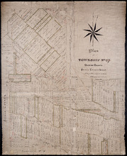
Plan of Township No. 67 Queens County Prince Edward Island: A Copy of a Plan compiled by Geo.…
Description: A copy of a plan of Lot 67 compiled by Geo. Wright, 1858, slightly altered to agree with Meacham's Atlas (No.179). Shows names of residents and acreage, lots, streets and roads, and post offices. more
Province: Prince Edward Island
Type: cadastral maps
Date Created: 1885-07
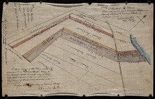
Plan of part of Lot 47: The Estate of the late Alexander McDonald showing allotments pursuant to…
Description: Plan of part of Lot 47. The estate of the late Alexander McDonald showing allotments pursuant to Order of Supreme Court Schedule G. The map shows the estate of the late Alexander McDonald divided… more
Province: Prince Edward Island
Type: cadastral maps
Date Created: 1885-07-07
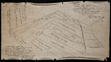
Plan of part of Lot 47: The estate of the late Alexander McDonald showing the different kinds of…
Description: Plan of part of Lot 47. The estate of the late Alexander McDonald showing the different kinds of land. Schedule F. The map, drawn in black ink, shows the estate of the late Alexander McDonald divided… more
Province: Prince Edward Island
Type: cadastral maps
Date Created: 1885-07-07