Displaying 1 - 6 of 6
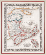
County Map of Nova Scotia New Brunswick Cape Breton Id. and Pr. Edward's Id.
Description: The map shows New Brunswick, Nova Scotia and Prince Edward Island and parts of Quebec and Maine. An inset shows the "City and Harbor of Halifax." Bright colours are used to outline… more
Publisher: S. A. Mitchell Jr.
Province: New Brunswick, Nova Scotia, Prince Edward Island
Type: topographic maps
Date Created: 1860

A Plan of the undisposed of Part, of Lot No. 38 in Queens County in Prince Edward Island
Description: A plan of the undisposed part of Lot 58 (No.154). Shows residents, lots, roads, and water. Surveyed by Rod'k Campbell. more
Province: Prince Edward Island
Type: cadastral maps
Date Created: 1860
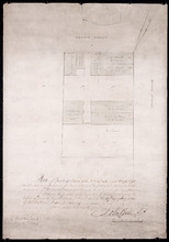
Plan of part of Town Lots Nos. 54 and 55, and Nos. 91 and 92 in the 2nd Hundred of Town Lots in…
Description: Plan of part of Town Lots Nos. 54 and 55, and Nos. 91 and 92 in the 2nd Hundred of Town Lots in Charlottetown agreeably to the possession of the Misses Stewart according to the original survey of the… more
Province: Prince Edward Island
Type: cadastral maps
Date Created: 1860-07-25
A Plan of the undisposed of Parts of Lot No. 62 in Queens County in Prince Edward Island by Rodk.…
Description: A plan of the undisposed part of Lot 62. Selkirk Estate (No.164). Shows names of residents and acreage.
Province: Prince Edward Island
Type: cadastral maps
Date Created: 1860
A Plan of the undisposed of Parts of Lot No. 60 in Queens County in Prince Edward Island by Rodk.…
Description: A plan of the undisposed parts of Lot 60. Code indicates tracts of land sold and tracts of land without lease. Shows names of residents and acreage. Surveyed by Rod'k Campbell. A nautical… more
Province: Prince Edward Island
Type: cadastral maps
Date Created: 1860
A Plan of the undisposed of Parts of Lot No. 57: in Queens County in Prince Edward Island
Description: A plan of the undisposed of parts of Lot 57. Surveyed by Rod'k Campbell. The map shows parcels of land with names of owners or occupants and their corresponding acreage amounts handwritten in… more
Province: Prince Edward Island
Type: cadastral maps
Date Created: 1860