Displaying 1 - 17 of 17

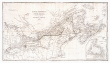
Prince Edward Island Nova Scotia and New Brunswick: Prince, Queens and Kings Counties, P.E.I.…
Description: Prince, Queens and Kings Counties, Prince Edward Island, portions of New Brunswick, Nova Scotia, and Magdalen Islands. It marks counties, parishes, cities, towns, and villages, beaches, marshes, Lots… more
Publisher: Hydrographic and Map Service, Labelle Building
Province: Prince Edward Island, Nova Scotia, New Brunswick, Quebec
Type: cadastral maps
Date Created: 1940
British possessions in North America from the Report of the Emigration Committee of 1827
Description: British possessions in North America, for the report of the Emigration Committee of 1827, corrected to 1834. Published by Longman & Co., London.
Publisher: Ashby, H., Longman & Co.
Province: New Brunswick, Nova Scotia, Prince Edward Island, Quebec, Maine, Vermont
Type: cadastral maps, topographic maps
Date Created: 1834
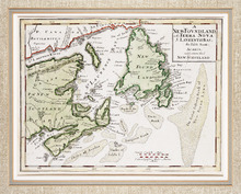
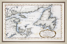
Carte Nouvelle contenant la Partie d'Amerique La Plus Septentrionale, ou sont exactement…
Description: The map shows the Gulf of St. Lawrence, the northeast Atlantic and the provinces of New Brunswick, Newfoundland, Nova Scotia and Prince Edward Island, as well as part of Quebec. Sable Island,… more
Province: New Brunswick, Newfoundland, Nova Scotia, Prince Edward Island, Quebec
Type: topographic maps
Date Created: 1666
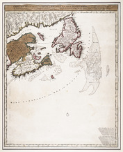
A NewFoundland, od. Terra Nova S. Laurentii Bay, die Fisch-Bank, Acadia, nebst einem Theil New…
Description: The map shows the Gulf of St. Lawrence, part of the northeast Atlantic and the provinces of New Brunswick, Newfoundland, Nova Scotia and Prince Edward Island, as well as part of Quebec. Sable Island… more
Province: New Brunswick, Newfoundland, Nova Scotia, Prince Edward Island, Quebec
Type: topographic maps
Date Created: 1720
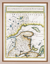
Carta Rappresentante il Golfo del Fiume S. Lorenzo
Description: The map shows the St. Lawrence River/Gulf of St. Lawrence region as far west as the Saguenay River and as far east as Cape Breton. It shows New Brunswick, Prince Edward Island, and parts of Nova… more
Province: New Brunswick, Nova Scotia, Prince Edward Island, Quebec
Type: topographic maps
Date Created: 1765 (year approximate)
Carte du Golphe de St. Laurent et Pays Voisins Pour Servir a l'Histoire Generale des Voyages.
Description: The map shows the Gulf of St. Lawrence, New Brunswick, Newfoundland, Prince Edward Island, and parts of Nova Scotia and Quebec. It shows Anticosti Island and the Magdelan Islands. The map uses labels… more, Provenance: Purchased by Mr. Macnutt in London at the Map House in 1982. [Information from the back of the item], Exhibition & Catalogue: 1. The James W. Macnutt Collection of Maps of the Gulf of St. Lawrence with Particular Emphasis on Prince Edward Island, Confederation Centre Art Gallery and Museum, June… more
Province: New Brunswick, Newfoundland, Nova Scotia, Prince Edward Island, Quebec
Type: topographic maps
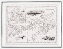
The British Colonies in North America
Description: The map shows New Brunswick, Nova Scotia, Prince Edward Island and parts of Ontario, Quebec and the United States. Newfoundland is shown at the same scale in an inset in the upper left corner. Rivers… more
Publisher: James S. Virtue
Province: New Brunswick, Newfoundland, Nova Scotia, Prince Edward Island, Ontario, Quebec
Type: topographic maps
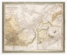
Canada East, Formerly Lower Canada. [with] Nova Scotia, New Brunswick &c.: Published by S.…
Description: The map shows part of Quebec (Canada East) and adjoining parts of New Brunswick and the United States. An inset map shows New Brunswick, Nova Scotia and Prince Edward Island. Colour is used to… more
Publisher: S. Augustus Mitchell
Province: New Brunswick, Nova Scotia, Prince Edward Island, Quebec
Type: topographic maps
Date Created: 1846

Geological Map of Canada and Newfoundland: Derive from the Results of The Canadian Geological…
Description: Framed map of Canada and Newfoundland. The map is has colours for different land marks, and a table that explains it all. Shown are bodies of water such as rivers, islands, roads, towns, and cities.
Province: Newfoundland, New Brunswick, Prince Edward Island, Nova Scotia, Quebec
Type: geological maps
Date Created: 1866 (year uncertain)
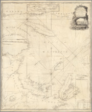
A New Chart of the Gulf of St. Lawrence Compiled from the Original Drawings of Actual Surveys
Description: The most accurate chart of the Gulf of St. Lawrence in 1790, especially its depiction of Cape Breton Island. "The Most Detailed Chart of the St. Lawrence River to Date Fine example of Thomas… more
Publisher: William Faden
Province: Prince Edward Island, Nova Scotia, New Brunswick, Quebec
Type: nautical charts
Date Created: 1790
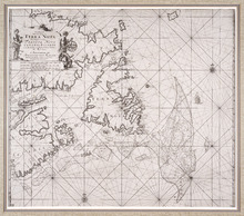
Pas-kaart, Vande Zee-Kusten van, Terra Nova, Met de Byleggende Zee-Kusten van Francia Nova Canada…
Description: Rectangular engraved map of Newfoundland, Nova Scotia, Prince Edward Island, and part of Quebec; framed and covered with glass. Black and white. Depicts Newfoundland, Nova Scotia, Cape Breton, Prince… more
Province: Newfoundland, Nova Scotia, Prince Edward Island, Quebec
Type: topographic maps
Date Created: 1687
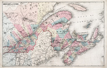
Dominion of Canada: (Eastern Sheet)
Description: Map showing the province of Quebec, New Brunswick, Nova Scotia, and Prince Edward Island. Shows rivers, lakes, channels, bays, roads, railroads, cities, and towns. The provinces and cities are tinted… more
Publisher: J. H. Meacham & company
Province: Quebec, New Brunswick, Nova Scotia, Prince Edward Island
Type: pictorial maps
Date Issued (Source): 1880
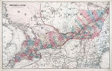
Dominion of Canada: (Western Sheet)
Description: Map showing the province of Ontario, and Quebec. Shows rivers, lakes, channels, bays, roads, railroads, cities, towns, copper mines, and sea measurements. Ontario and Quebec are coloured and cities… more
Publisher: J. H. Meacham & company
Province: Ontario, Quebec, Prince Edward Island, Michigan, New York, Ohio
Type: cadastral maps
Date Issued (Source): 1880
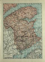
Province of New Brunswick and part of Quebec, Canada
Description: The map shows the Provinces of New Brunswick and part of Quebec, Canada. Shown are Prince Edward Island, United States, Nova Scotia, St. Lawrence River and Gulf, Northumberland Strait, Bay of Fundy,… more
Publisher: Cummins Map Co.
Province: Nova Scotia, Prince Edward Island, Quebec, New Brunswick
Type: cadastral maps
Date Issued (Source): 1927
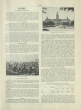
Quebec - 1
Description: Text provides information of history, population, and farming industry of Quebec
Publisher: Cummins Map Co.
Province: Quebec
Type: text
Date Issued (Source): 1927
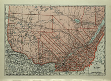
Province of Quebec, Canada
Description: The map shows the province of Quebec in Canada. Shown are Ontario, New York, Maine, towns, cities, raods, railroads, and St. Lawrence River.
Publisher: Cummins Map Co.
Province: Quebec
Type: cadastral maps
Date Issued (Source): 1927
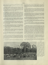
Quebec - 2
Description: Text provides information of the farming industry of Quebec
Publisher: Cummins Map Co.
Province: Quebec
Type: text
Date Issued (Source): 1927