Displaying 1 - 11 of 11
Carte Nouvelle contenant la Partie d'Amerique La Plus Septentrionale, ou sont exactement…
Description: The map shows the Gulf of St. Lawrence, the northeast Atlantic and the provinces of New Brunswick, Newfoundland, Nova Scotia and Prince Edward Island, as well as part of Quebec. Sable Island,… more
Province: New Brunswick, Newfoundland, Nova Scotia, Prince Edward Island, Quebec
Type: topographic maps
Date Created: 1666
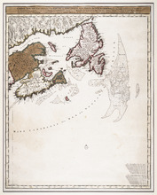
A NewFoundland, od. Terra Nova S. Laurentii Bay, die Fisch-Bank, Acadia, nebst einem Theil New…
Description: The map shows the Gulf of St. Lawrence, part of the northeast Atlantic and the provinces of New Brunswick, Newfoundland, Nova Scotia and Prince Edward Island, as well as part of Quebec. Sable Island… more
Province: New Brunswick, Newfoundland, Nova Scotia, Prince Edward Island, Quebec
Type: topographic maps
Date Created: 1720
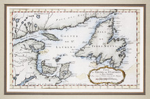
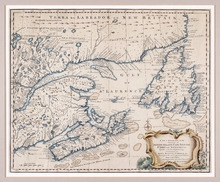
Carte du Golphe de St. Laurent et Pays Voisins Pour Servir a l'Histoire Generale des Voyages.
Description: The map shows the Gulf of St. Lawrence, New Brunswick, Newfoundland, Prince Edward Island, and parts of Nova Scotia and Quebec. It shows Anticosti Island and the Magdelan Islands. The map uses labels… more, Provenance: Purchased by Mr. Macnutt in London at the Map House in 1982. [Information from the back of the item], Exhibition & Catalogue: 1. The James W. Macnutt Collection of Maps of the Gulf of St. Lawrence with Particular Emphasis on Prince Edward Island, Confederation Centre Art Gallery and Museum, June… more
Province: New Brunswick, Newfoundland, Nova Scotia, Prince Edward Island, Quebec
Type: topographic maps
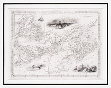
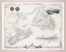
The British Colonies in North America
Description: The map shows New Brunswick, Nova Scotia, Prince Edward Island and parts of Ontario, Quebec and the United States. Newfoundland is shown at the same scale in an inset in the upper left corner. Rivers… more
Publisher: James S. Virtue
Province: New Brunswick, Newfoundland, Nova Scotia, Prince Edward Island, Ontario, Quebec
Type: topographic maps
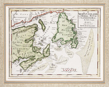
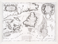
Nova Scotia and Newfoundland
Description: The map shows Newfoundland, Nova Scotia and Prince Edward Island and parts of New Brunswick and Quebec. Newfoundland, Nova Scotia, P.E.I., Anticosti Island and the Magdalen Islands are mapped in… more
Publisher: J. & F. Tallis
Province: Newfoundland, Nova Scotia, Prince Edward Island
Type: topographic maps
Date Created: 1851

Geological Map of Canada and Newfoundland: Derive from the Results of The Canadian Geological…
Description: Framed map of Canada and Newfoundland. The map is has colours for different land marks, and a table that explains it all. Shown are bodies of water such as rivers, islands, roads, towns, and cities.
Province: Newfoundland, New Brunswick, Prince Edward Island, Nova Scotia, Quebec
Type: geological maps
Date Created: 1866 (year uncertain)
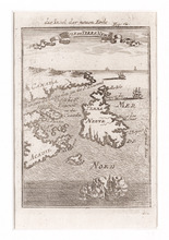
Canada Orientale nell' America Settentrionale: descritta dal P. Mro. Coronelli M C Cosmografo…
Description: Rectangular map, black on white paper. The map shows Newfoundland; Prince Edward Island; Anticosti Island; Cape Breton; part of mainland Nova Scotia; part of New Brunswick; part of Quebec; and part… more
Province: Newfoundland, Nova Scotia, Prince Edward Island
Type: topographic maps
Date Created: 1695
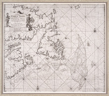
Pas-kaart, Vande Zee-Kusten van, Terra Nova, Met de Byleggende Zee-Kusten van Francia Nova Canada…
Description: Rectangular engraved map of Newfoundland, Nova Scotia, Prince Edward Island, and part of Quebec; framed and covered with glass. Black and white. Depicts Newfoundland, Nova Scotia, Cape Breton, Prince… more
Province: Newfoundland, Nova Scotia, Prince Edward Island, Quebec
Type: topographic maps
Date Created: 1687
A New and Accurate Map of the Islands of Newfoundland, Cape Briton, St. John and Anticosta:…
Description: Map, showing the Maritime provinces; the vertical fold indicates that it originally appeared in a book or atlas; cartouche in bottom right corner. Port Joy is the only settlement named on Isle St.… more
Publisher: Astron Obervat
Province: Nova Scotia, Newfoundland, Cape Breton, St. John, Anticosta
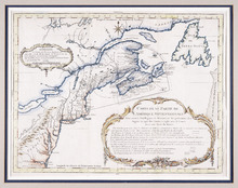
Carte d'Une Partie de l'Amérique Septentrionale : Pour Servir à l'Intelligence du…
Description: Framed map of America in French, Title and a table of explanation along with an Avertissement are inside an elborate design. The map also shows bodies of water such as Lac Erie and Ontario, towns and… more
Province: Nova Scotia, Prince Edward Island, New Brunswick, Newfoundland
Type: topographic maps
Date Created: 1751
Die Insel der Neuen Erde : Isle de Terre Newe
Description: Two maps of Acadia in the 18th century in one frame; .1 coloured, .1 uncoloured.The map shows Canada, Acadie, and Terre Neuve, islands, water, and paintings of ships.
Province: Newfoundland, Nova Scotia, New Brunswick, Prince Edward Island
Type: topographic maps
Date Created: 1690