Displaying 1 - 9 of 9
Plan of Half Township No. 65 One of the Estates of the Misses Fanning - Prince Edward Island: From…
Description: Plan of the eastern half of Lot 65 (No. 175). The Misses Fanning Estate. The map shows lots, residents, roads, and bodies of water such as rivers.
Province: Prince Edward Island
Type: cadastral maps

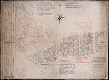
Plan of the Western Portion of Township No. 65: containing 5250 acres and belonging to Mrs. Lydia…
Description: Plan of the western portion of Lot 65 (No.173). Estate of Mrs Lydia Wright. Roads, leased land[?] and freehold land on the Estate of Mrs. Lydia Wright. Tenant names appear on the sub-lots, which are… more
Province: Prince Edward Island
Type: cadastral maps
Date Created: 1841
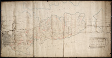
Plan of the division line between Lots 31 and 65, the commencement of which was set by the…
Description: Plan of the division line between Lots 31 and 65, the commencement of which was set by the Commissioners for establishing boundary lines. (No.1) The map shows lots, roads, and rivers.
Province: Prince Edward Island
Type: cadastral maps
Date Created: 1837-08-26

Plan of the Western Portion of Township No. 65: containing 5250 acres and belonging to Mrs. Lydia…
Description: Plan of the western portion of Lot 65 (No.173). Estate of Mrs Lydia Wright. Roads, leased land[?] and freehold land on the Estate of Mrs. Lydia Wright. Tenant names appear on the sub-lots, which are… more
Province: Prince Edward Island
Type: cadastral maps
Date Created: 1841

Plan of 1390 Acres of Land part of Township No. 65: The property of the Hon,, Smauel Cunard…
Description: Plan of part of Lot 65 (No.172). 1390 acres of land, part of the property of the Hon. Samuel Cunard. One of the plans referred to in the Deed from Sir Edward, William, and Laura Cunard to the… more
Province: Prince Edward Island
Type: cadastral maps
Date Created: 1866-07-13
Plan of 1390 Acres of Land part of Township No. 65: The Property of the Honble. Samuel Cunard.…
Description: Plan of Lot 65 (No.178). Shows names of residents, acreage, and land conveyance references. Color code indicates freehold land and the estates of the Wrights, Cunard and Cumberland. Shows bodies of… more
Province: Prince Edward Island
Type: cadastral maps
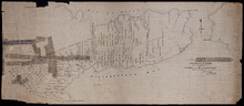
Plan of Part of Township No. 65: The Property of Col. B.H. and Mrs Cumberland
Description: Plan of part of Lot 65 (No.171). The property of Col. B.H. and Mrs Cumberland. Shows names of residents and acreage. Plan copied by R.T. Weeks. The map shows bodies of water such as Elliott River,… more
Province: Prince Edward Island
Type: cadastral maps
Lot 65: Queens County
Description: The map shows Lot 65 in Queens County. Shown are the Northumberland Strait, Hillsborough Bay, Elliott River, roads, landowners, acreage, and towns.
Publisher: Cummins Map Co.
Province: Prince Edward Island
Type: cadastral maps
Date Issued (Source): 1927
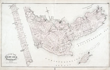
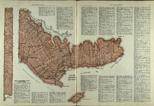
Plan of Lot 65 : Queens Co., P.E.I.
Description: The map shows Lot 65 in Queens county. Shown are roads, landowners and acreage, creeks, rivers, straits, marshes, brooks, coves, sand, reef, fishing stage, wharfs, post offices, mills, churches,… more
Publisher: J. H. Meacham & company
Province: Prince Edward Island
Type: cadastral maps
Date Issued (Source): 1880