Displaying 1 - 7 of 7

Plan of Township No. 64: compiled from the proprietors' plans, descriptions in leases and…
Description: The map shows Lot 64 divided into parcels of land with names of residents, their acreage amounts and land conveyence references. Land information written in black indicates government land;… more
Province: Prince Edward Island
Type: cadastral maps
Date Created: 1920
A Plan of Lot No. LXIV: The Property of J. Cambridge Esqr. Situate in Kings County P. E. Island…
Description: Plan of Lot 64 (No. 2). The property of J. Cambridge. The map shows Lot 64 partially divided into parcels of land with the names of residents and their acreage amounts. The map shows roads, which are… more
Province: Prince Edward Island
Type: cadastral maps
Date Created: 1829-03
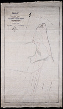
Plan of Shore and Land connected with The Beach Fishery Station Murray Harbour: The Property of Hon…
Description: Plan of part of Lot 64. The shore and land connected with the Beach Fishery Station, Murray Harbour. The property of the Hon. David Davies. The map shows lots, residents, bodies of water, and roads.
Province: Prince Edward Island
Type: cadastral maps
Date Created: 1872-10-29

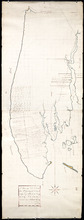
Plan of Township No. 64: St. Andrews Parish, Queens County, P. E. Island
Description: Lot 64 is situated in Kings County, not Queens County as stated in the map title. The map shows Lot 64 divided into parcels of land with names of residents and their acreage amounts. Several parcels… more
Province: Prince Edward Island
Type: cadastral maps
Date Created: 1850

Plan of Township 64
Description: Plan of Lot 64 (No.169). Cunard Estate. Shows names of residents, acreage, and land conveyance references. The map shows bodies of water such as Gulf of Saint Lawrence, and Murray River, Murray… more
Province: Prince Edward Island
Type: cadastral maps
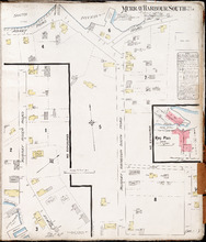
Murray Harbour South P.E.I., Kings Co.: Population 350. No Protection. Octr. 1910
Description: This is a fire insurance plan of the community of Murray Harbour South that consists of two maps--one for each side of the South River. The smaller map, on the left side of the page, shows an area of… more
Publisher: Chas. E. Goad, Civil Engineer
Province: Prince Edward Island
Type: fire insurance maps
Date Created: 1910-10
Date Issued (Source): 1888
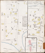
Murray River South P.E.I., Kings Co.: Population 300. No Protection. Oct 1910
Description: This is a fire insurance plan of the community of Murray River South that consists of two maps--one for each side of the Murray River. The larger map, on the left side of the page, shows an area of… more
Publisher: Chas. E. Goad, Civil Engineer
Province: Prince Edward Island
Type: fire insurance maps
Date Created: 1910-10
Date Issued (Source): 1888