Displaying 1 - 10 of 10
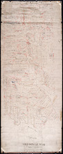
Plan of Township No. 56: Copied from the Survey of J. C. Underhay By Owen Curtis. L. S.
Description: Plan of Lot 56 (No.150). Shows names of residents, acreage, and some land conveyance references. Surveyed by J.C. Underhay and copied by Owen Curtis. The map also shows bodies of water such as… more
Province: Prince Edward Island
Type: cadastral maps

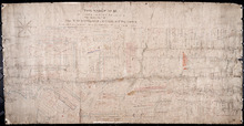
Plan of Township No. 56: referred to in the annexed Deed shewing the situation of lands conveyed by…
Description: Plan of Lot 56 showing the situation of 18,028 acres of land conveyed by T. Heath Haviland and G.W. DeBlois to the Commissioner of Public Lands. The map shows Lot 56 divided into parcels of land with… more
Province: Prince Edward Island
Type: cadastral maps
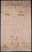
Plan of part of Lot 56
Description: Plan of part of Lot 56 showing the names of residents, acreage, a few land conveyance references, and roads. (No.151)
Province: Prince Edward Island
Type: cadastral maps
Date Created: 1882
Plan of Township No. 56: referred to in the annexed Deed shewing the situation of lands conveyed by…
Description: Plan of Lot 56 showing the situation of 18,028 acres of land conveyed by T. Heath Haviland and G.W. DeBlois to the Commissioner of Public Lands. The map shows Lot 56 divided into parcels of land with… more
Province: Prince Edward Island
Type: cadastral maps
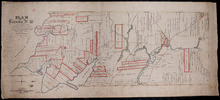
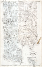
A Plan of Township No. 56 in Kings County P. E. Island, the Property of Hon. T. H. Haviland of…
Description: Plan of Lot 56 (No.149). Property of Hon. T.H. Haviland of Charlottetown. Shows names of residents and acreage, bodies of water such as rivers, bays, creeks, ponds, roads, and a nautical compass.
Province: Prince Edward Island
Type: cadastral maps
Date Created: 1864

Annandale, Lot 65
Description: This item may be a draft of a fire insurance plan of the community of Annandale. The map, drawn on a grid, in pencil, shows the area of Main Street and Lorne Street. It shows buildings, but they are… more
Province: Prince Edward Island
Type: fire insurance maps
Date Created: 1845
Date Issued (Source): 1888
Plan of Lot Thirty One: Queens Co., P.E.I.
Description: The map shows lot 31 in Queens county. Shown are rivers, landowners and acreage, post offices, creeks, railroads and stations, roads, churches, a ferry, and school houses. Compass. Illustrated… more
Publisher: J. H. Meacham & company
Province: Prince Edward Island
Type: cadastral maps
Date Issued (Source): 1880
Rural Directory - Lots 55 and 56, Kings County
Description: A directory listing of residents of lots 55 and 56
Publisher: Cummins Map Co.
Province: Prince Edward Island
Type: text
Date Issued (Source): 1927
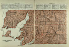
Lots 55 and 56: Kings County
Description: The map shows lots 55 and 56 in Kings county. Shown are bays, rivers, ponds, landowners, acreage, roads, coves, and Boughton Island.
Publisher: Cummins Map Co.
Province: Prince Edward Island
Type: cadastral maps
Date Issued (Source): 1927
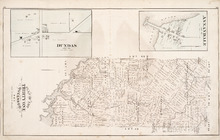
Plan of Lots 55 & 56: Kings Co., P.E.I.
Description: The map shows lots 55 & 56 in Kings county. Shown are roads, landowners and acreage, crosses, rivers, ponds, creeks, bays, coves, sand, wharfs, mills, post offices, churches, schools, and… more
Publisher: J. H. Meacham & company
Province: Prince Edward Island
Type: cadastral maps
Date Issued (Source): 1880