Displaying 1 - 11 of 11

Plan of the Cunard and Palmer Estates in Lot or Township No.1.
Description: Plan of Lot 1 (No.1). Cunard and Palmer Estates. Drawn by Owen Curtis. Shows names of residents, acreage, and a few land conveyance references, and roads.
Province: Prince Edward Island
Type: cadastral maps

A Trace of West Coast, Prince Edward Island: from the Survey by Capt. Bayfield, R.N. furnished at…
Description: Plan of the West Coast of Prince Edward Island from the survey by Capt. Bayfield furnished at the request of a Committee of the House of Assembly, March 18, 1842. The coast line marked in red has… more
Province: Prince Edward Island
Type: cadastral maps
Date Created: 1842
Paln No. 1 of Railway Appropriation: from Alberton to Tignish
Description: Plan of Railway Appropriations from Alberton to Tignish. (Plan No.1). The map shows roads, resdients, acreage, lots, and foliage.
Province: Prince Edward Island
Type: cadastral maps
Date Created: 1873
Plan No. 2 of Railway Appopriation: From Alberton to Tignish
Description: Plan of Railway Appropriations from Alberton to Tignish. (Plan No.2). The map shows roads, lots, residents, acreage, and foliage.
Province: Prince Edward Island
Type: cadastral maps
Date Created: 1873

Plan of the Western Moiety of Lot or Township 1 : Part of ot copied and part from actual survey by…
Description: Plan of the western moiety of Lot 1 (No.2), part of it copied and part from actual survey. Palmer Estate. The map shows residents and land acreage, ponds, and roads.
Province: Prince Edward Island
Type: cadastral maps
Date Created: 1854-08-05

Plan of Lot 1
Description: Plan of Lot 1 comprising the Palmer and part of the Cunard Estates. Surveyed by V.S. Gillis and others. Rolled map on fabric backing. Water is coloured blue. Properties include owner / occupant names… more
Province: Prince Edward Island
Type: cadastral maps
Date Created: Unknown year

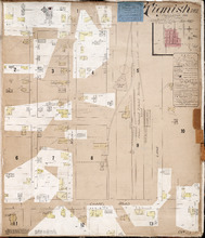
Tignish. P.E.I.: Population 500. No appliances. October 1888
Description: This is an older (1888, revised to 1893) version of a fire insurance plan of the village of Tignish. A more updated plan is shown on the map Tignish_1910. The map shows the area near Chapel Road and… more
Publisher: Chas. E. Goad, Civil Engineer
Province: Prince Edward Island
Type: fire insurance maps
Date Created: 1888-10
Date Modified: 1893-10
Date Issued (Source): 1888
Tignish P.E.I.: Population: 500. Hook & Ladder. Nov 1897.
Description: This is a fire insurance plan of the village of Tignish. It was created in 1897 and revised to 1910. (An older plan is shown on the map Tignish_1893.) The map shows the area near Chapel Road and the… more
Publisher: Chas. E. Goad, Civil Engineer
Province: Prince Edward Island
Type: fire insurance maps
Date Created: 1897-11
Date Modified: 1910-10
Date Issued (Source): 1888
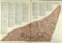
Lot No. 1 : Prince County
Description: The map shows Lot 1 in Prince county. Shown are the Gulf of St. Lawrence, ponds, rivers, creeks, landowners, acreage, roads and a railroad.
Publisher: Cummins Map Co.
Province: Prince Edward Island
Date Issued (Source): 1927

Plan of Lot One: Prince Co., P.E.I.
Description: Map showing the northWestern tip of the island. It names the gulfs, rivers, ponds, landowners and acreage, roads, and railroads. A graphic compass.
Publisher: J. H. Meacham & company
Province: Prince Edward Island
Type: cadastral maps
Date Issued (Source): 1880

Tignish, Prince Co.: Campbellton
Description: The map shows Lot 1 in Tignish, Prince county. Shown are roads, landowners and acreage, a church, chapel, and convent, a cemetery, railroad and station, grammar school, business, and houses. Compass.
Publisher: J. H. Meacham & company
Province: Prince Edward Island
Type: cadastral maps
Date Issued (Source): 1880