Displaying 1 - 4 of 4
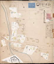
Crapaud P.E.I.: Population 300. No Appliances. Novr. 1897.
Description: This is a fire insurance plan of the village of Crapaud. It was created in 1897 and revised to 1910. The main map shows Main Street and the area where the roads into town converge. The Crapaud… more
Publisher: Chas. E. Goad, Civil Engineer
Province: Prince Edward Island
Type: fire insurance maps
Date Created: 1897-11
Date Modified: 1910-10
Date Issued (Source): 1888
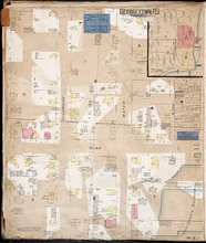
Georgetown P.E.I.
Description: This is the first of two pages of fire insurance maps of Georgetown. It was created in 1888, revised to 1897, and revised again to 1910. This page concentrates on an area one and a half blocks west… more
Publisher: Chas. E. Goad, Civil Engineer
Province: Prince Edward Island
Type: fire insurance maps
Date Created: 1888-10
Date Modified: 1897-11, 1910-09
Date Issued (Source): 1888
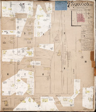
Tignish P.E.I.: Population: 500. Hook & Ladder. Nov 1897.
Description: This is a fire insurance plan of the village of Tignish. It was created in 1897 and revised to 1910. (An older plan is shown on the map Tignish_1893.) The map shows the area near Chapel Road and the… more
Publisher: Chas. E. Goad, Civil Engineer
Province: Prince Edward Island
Type: fire insurance maps
Date Created: 1897-11
Date Modified: 1910-10
Date Issued (Source): 1888
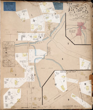
Tyne Valley P.E.I.: Novr. 1897. 1 Mile West of Port Hill Station. Population 300. No Appliances.…
Description: This is a fire insurance plan of Tyne Valley. It was created in 1897, revised to 1903, and then revised again to October, 1910. It shows the town in two (2) sections that are intended to be… more
Publisher: Chas. E. Goad, Civil Engineer
Province: Prince Edward Island
Type: fire insurance maps
Date Created: 1897-11
Date Modified: 1903-07, 1910-10
Date Issued (Source): 1888