Displaying 55 - 81 of 297
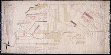
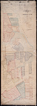
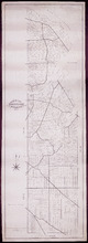
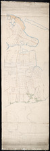
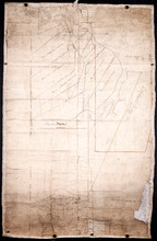
Titles to Lot 31
Description: Plan of Lot 31 (No.84). Douse Estate. Shows names of some residents, some acreage, some land conveyance references, roads, and a nautical compass.
Province: Prince Edward Island
Type: cadastral maps
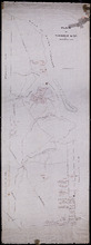
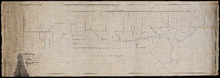
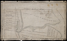
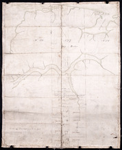
Plan of the East Moriety of Lot or Township No 29: part of the Estate of Lord Vicount Melville…
Description: Plan of the east moiety of Lot 29 (No.79). Part of the estate of Lord Viscount Melville. Shows names of residents, acreage, and a few land conveyance references, bodies of water such as the… more
Province: Prince Edward Island
Type: cadastral maps
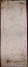
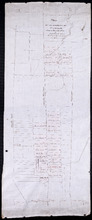
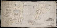
Plan "A" Part of Township No. 24: as divided amongst the children of the late Alfred…
Description: Plan "A" part of Lot 24 as divided amongst the children of the late Alfred Winsloe (No.64). Shows names of residents and acreage, bodies of water such as rivers, creeks, roads, and a… more
Province: Prince Edward Island
Type: cadastral maps
Date Created: 1872-06-11
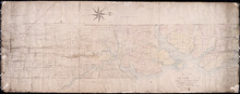
Plan of Lot 24 (No.66): Part of the estate of John Hodges Winsloe
Description: Plan of Lot 24 (No.66). Part of the estate of John Hodges Winsloe. Shows names of residents, acreage, and a few land conveyance references, bodies of water such as Gulf of St. Laurence, rivers, roads… more
Province: Prince Edward Island
Type: cadastral maps
Date Created: 1847
This is the Plan of Township No. 24 in Prince Edward Island
Description: Plan of Lot 24 showing the division of the Winsloe Estate. Shows names of residents and acreage, bodies of water such as gulfs, bays, creeks, rivers, sand hills, Rustico or Peter's Island and… more
Province: Prince Edward Island
Type: cadastral maps
Date Created: 1863-03-13
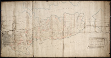
Plan of Township No. 24 in Prince Edward Island
Description: Plan of Lot 24. Smith Estate. Mainly outline but shows a few residents and acreage, bodies of water such as rivers, gulfs, bays and creeks, roads, sand hills, and Rustico or Peter's Island. more
Province: Prince Edward Island
Type: cadastral maps
Plan of the property of Mrs W.L. Smith : Situate on Township No. 24 in Prince Edward Island, Mrs L…
Description: Plan of the property of Mrs W.S. Smith. Situated on Lot 24. The maps shows bodies of water such as rivers and creeks, Rustico Island, roads, and a nautical compass.
Province: Prince Edward Island
Type: cadastral maps
Plan of Township No. 24 Situate in Grenville Parish. Queen's County. P.E.Island.: Complied…
Description: Plan of Lot 21 situate in Grenville Parish (No.54). Compiled from actual surveys. Cunard Estate. Shows names of residents and acreage, bodies of water such as gulfs, rivers, and creeks, roads, and a… more
Province: Prince Edward Island
Type: cadastral maps
Date Created: 1844
Plan of Lot Twenty One : Queens Co P.E.I.
Description: Plan of Lot 21 drawn from old maps, plans, and records. Shows names of residents, acreage, and land conveyance references, bodies of water such as bays, ponds, gulfs, and rivers, roads, and a… more
Province: Prince Edward Island
Type: cadastral maps
Date Created: 1952
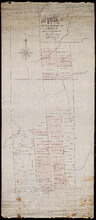
Plan of Lot 58
Description: Plan of Lot 58 divided into four sections. Shows Refugee Shares drawn for 12th February, 1784. Shown are lots, residents, and bodies of water.
Province: Prince Edward Island
Type: cadastral maps
Date Created: 1784-02-12

A Plan of the undisposed of Part, of Lot No. 38 in Queens County in Prince Edward Island
Description: A plan of the undisposed part of Lot 58 (No.154). Shows residents, lots, roads, and water. Surveyed by Rod'k Campbell. more
Province: Prince Edward Island
Type: cadastral maps
Date Created: 1860
Plan of Half Township No. 65 One of the Estates of the Misses Fanning - Prince Edward Island: From…
Description: Plan of the eastern half of Lot 65 (No. 175). The Misses Fanning Estate. The map shows lots, residents, roads, and bodies of water such as rivers.
Province: Prince Edward Island
Type: cadastral maps
Plan of the Western Portion of Township No. 65: containing 5250 acres and belonging to Mrs. Lydia…
Description: Plan of the western portion of Lot 65 (No.173). Estate of Mrs Lydia Wright. Roads, leased land[?] and freehold land on the Estate of Mrs. Lydia Wright. Tenant names appear on the sub-lots, which are… more
Province: Prince Edward Island
Type: cadastral maps
Date Created: 1841
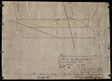
Plan of the Moiety of Lot or Township No 29 of the Estate of Viscount elville situated in Prince…
Description: Plan of the east moiety of Lot 29 (No.2). Part of the estate of Lord Viscount Melville. The map shows lots, residents, roads, and bodies of water such as rivers.
Province: Prince Edward Island
Type: cadastral maps
Plan Showing the situation of the Estate of Mr. Clement White on Lot or Township No. 32
Description: Plan of part of Lot 32 (No.21). The estate of Mr. Clement White. The map shows lots, residents, roads, and York (or North) River.
Province: Prince Edward Island
Type: cadastral maps
Date Created: 1874-01
Plan of the Property of Mrs Smith situate in Township No 33 in Prince Edward Island: Mrs S's…
Description: Plan of part of Lot 33 showing the property of Mrs. S.W. Smith. The map shows lots, residents, acreage, roads, and water.
Province: Prince Edward Island
Type: cadastral maps
Plan of the Property of Ms S W Smith Situate on Township No 33 in Prince Edward Island: Mrs S'…
Description: Plan of part of Lot 33, showing the property of Mrs. S.W. Smith. The map shows lots, residents, roads, and bodies of water such as rivers.
Province: Prince Edward Island
Type: cadastral maps
Plan of Lot 35
Description: Plan of Lot 35 (No.95). Shows some residents, lots, roads, bodies of water and foliage.
Province: Prince Edward Island
Type: cadastral maps
Part of Lot 35 in Queens county
Description: Plan of part of Lot 35 (No.631). The Estate of John A. MacDonald. Shows area around Johnston's River. Date of plan: post 1811, after the death of Captain MacDonald. The map shows lots, residents… more
Province: Prince Edward Island
Type: cadastral maps
Plan of part of Township Number 35 situate on the North side of the Hillsborough River.: Those…
Description: Plan of Lot 35 (No.1). North side of the Hillsborough River. Property of Rev. John MacDonald. From a tracing by W.C. Harris. The map shows lots, residents, roads, and bodies of water.
Province: Prince Edward Island
Type: cadastral maps
Date Created: 1878-03-21
Plan of Part of Township no 35 on Bedford Bay
Description: Plan of part of Lot 35 (No.631) bordering on Bedford Bay. The map shows lots, residents, roads, and various bodies of water.
Province: Prince Edward Island
Type: cadastral maps
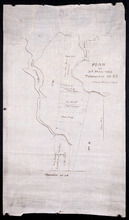
Plan of Part of Township No. 35 on the North Side of the Hillsborough River
Description: Plan of part of Lot 35 on the north side of the Hillsborough River. The map shows lots, residents, roads, Bedford Bay and foliage.
Province: Prince Edward Island
Type: cadastral maps
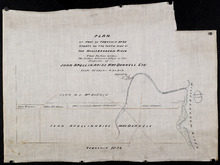
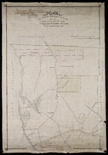
Plan of Part of Township No. 35 situate on the South Side of the Hillsborough River
Description: Plan of part of Lot 35 situate on the south side of the Hillsborough River. The property of John Apollinarius MacDonnell. Plan copied by R.T. Weeks. The map shows lots, residents, roads, islands, and… more
Province: Prince Edward Island
Type: cadastral maps
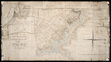
Plan of St Martins Township No 35
Description: Plan of part of Lot 35, St. Martins. The map shows lots, residents, and bodies of water such as rivers.
Province: Prince Edward Island
Type: cadastral maps
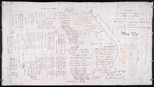
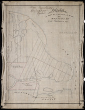
Plan if the Southren Moiety of Township No 36 Part of the Estate of the Rev: John Alister Somerlet…
Description: Plan of the southern moiety of Lot 36 (No.2). Part of the estate of the Rev. John Alister Somerlet MacDonald. From a tracing by W.C. Harris. The map shows lots, residents, a pond, and roads.
Province: Prince Edward Island
Type: cadastral maps
Date Created: 1878-03-22
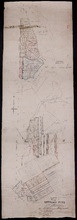
Plan of Lot 37
Description: Plan of Lot 37, north of the Hillsborough River. Shows some residents, lots, roads, and bodies of water.
Province: Prince Edward Island
Type: cadastral maps
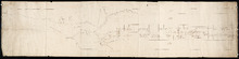
Surveyor General's Plan for south western half of Lot 37
Description: Surveyor General's Plan for south western half of Lot 37 (No.1). The map shows lots, residents, and bodies of water. more
Province: Prince Edward Island
Type: cadastral maps