Displaying 55 - 81 of 176
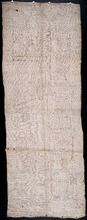
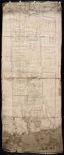
Plan of Lot 47
Description: Plan of Lot 47 (No. 127). Stewart and Cunard Estates. The map shows Lot 47 divided into parcels of land with the names of residents, acreage amounts and land conveyance references. Some areas of the… more
Province: Prince Edward Island
Type: cadastral maps
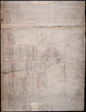
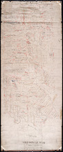
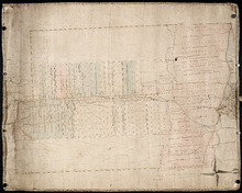
Plan of Lots 38, 39, 40, 41, 42, 66 and part of Lot 43
Description: The map shows some of the lots and parishes in a northern portion of Kings County. It shows Savage Harbour, St. Peter's Bay, rivers, streams, mills, roads, buildings and churches. The map has a… more
Province: Prince Edward Island
Type: topographic maps
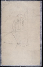
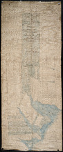
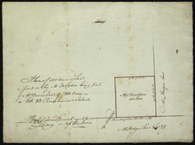
Part of Lot 38
Description: The map, drawn in pencil, shows four numbered parcels of land on or near Savage Harbour in the northern portion of Lot 38. It includes names of residents and land conveyance references. At least… more
Province: Prince Edward Island
Type: cadastral maps

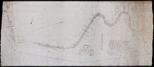
Tracing of the right of way for the Prince Edward Island Railway into Georgetown.
Description: Tracing of the right of way for the Prince Edward Island Railway into Georgetown.
Province: Prince Edward Island
Type: cadastral maps
This Plan shewing the lands appropriated by the Railway Commisioners is filed with the Office of…
Description: Prince Edward Island Railway. Plan shows land appropriated by the Railway Commissioners on Lot 45. (No.235C). The map shows residents, acreage, roads, and a church.
Province: Prince Edward Island
Type: cadastral maps

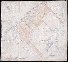
Plan of Georgetown, Georgetown Common, and Georgetown Royalty
Description: Plan of Georgetown, Georgetown Common, and Georgetown Royalty. Shows lot numbers. Gives names of a few residents in the Royalty. Also gives nautical soundings for Albion Bay and Brudenell River.
Province: Prince Edward Island
Type: cadastral maps
Date Created: 1828

Plan of Lot 54. Incomplete.
Description: Plan of Lot 54. Incomplete. Shows names of some residents, lots, acreage, roads, and bodies of water such as creeks.
Province: Prince Edward Island
Type: cadastral maps
Plan of Lot 54
Description: Plan of Lot 54. Shows names of residents, lots, roads, and bodies of water such as rivers.
Province: Prince Edward Island
Type: cadastral maps

A Plan showing the Position of the Line of Road through, proposes to be run through Lot 47 from…
Description: Plan of existing and proposed road through Lot 47 from George Munn's, West River, to the bridge on the north side of Surveyor's Pond. Distance of 4 miles and 2 chains. Road run under the… more
Province: Prince Edward Island
Type: cadastral maps
Date Created: 1851-08

Plan of Murray River Lot 63: North of the River
Description: Plan of part of Murray River, Lot No.63. Area north of the River and west of Main Street. The map shows residents, lots, acreage, roads, towns, and a nautical compass.
Province: Prince Edward Island
Type: cadastral maps
Date Created: 1958
Plan of Township No. 56: Copied from the Survey of J. C. Underhay By Owen Curtis. L. S.
Description: Plan of Lot 56 (No.150). Shows names of residents, acreage, and some land conveyance references. Surveyed by J.C. Underhay and copied by Owen Curtis. The map also shows bodies of water such as… more
Province: Prince Edward Island
Type: cadastral maps

Plan of Township No. 55: Compiled from the plans on file in the Land and Registry Offices, from the…
Description: Plan of Lot 55 compiled from the plans on file in the Land and Registry Offices, from the descriptions in the registered Grants and from Meacham's Atlas. Shows names of residents, acreage, and… more
Province: Prince Edward Island
Type: cadastral maps
Date Created: 1919

Township No. Fiftyfour. St. Georges Parish. Kings County. Prince Edward Island.: Chiefly from…
Description: Plan of Lot 54 (No.145). Shows names of residents, acreage, and some land conveyance references. Copied by H.J. Cundall. Certified plan. The map also shows bodies of water such as rivers (Cardigan),… more
Province: Prince Edward Island
Type: cadastral maps

Plan of Township No. 56: referred to in the annexed Deed shewing the situation of lands conveyed by…
Description: Plan of Lot 56 showing the situation of 18,028 acres of land conveyed by T. Heath Haviland and G.W. DeBlois to the Commissioner of Public Lands. The map shows Lot 56 divided into parcels of land with… more
Province: Prince Edward Island
Type: cadastral maps

Plan of Lot 38
Description: Plan of Lot 38 showing the extent of land in possession of the Government...(?)
Province: Prince Edward Island
Type: cadastral maps

Plan of Lot or Township No. 39: from the lastest Surveys by Joseph Ball, S.G., July 1, 1857
Description: Plan of Lot 39 (No.104). Worrell Estate. Plan copied by Owen Curtis, 1876.
Province: Prince Edward Island
Type: cadastral maps
Date Created: 1857-07-01

Plan of Lot or Township No. 40: From latest Surveys by Joseph Ball and Owen Curtis, Land Surveyors.
Description: Plan of Lot 40 (No.109). Worrell Estate.
Province: Prince Edward Island
Type: cadastral maps

Plan of Lot or Township No. 41: From The Latest Surveys By Joseph Ball S.G., Copied by O. Curtis
Description: Plan of Lot 41 (No.111). Showing residents. Surveyed by Joseph Ball. Plan copied by Owen Curtis.
Province: Prince Edward Island
Type: cadastral maps

Lot 43: No. 1
Description: Plan of Lot 43 (No.1), showing Bay Fortune, Rollo Bay and North Shore areas.
Province: Prince Edward Island
Type: cadastral maps
Lot 43: Plan of that part of Division No. 1 Shaded Green on Lot or Township No. 43 containing 3467…
Description: Plan of that part of Lot 43 containing 3467 acres purchased by the Government.
Province: Prince Edward Island
Type: cadastral maps
Part of Lot 43
Description: Plan of part of Lot 43 (No.117). Townshend Estate.
Province: Prince Edward Island
Type: cadastral maps
Plan of Lot 44
Description: Plan of Lot 44. Old plan referred to in deed from Sir Ed. Cunard and others to the Commissioner for Public Lands, dated 13 July, 1866.
Province: Prince Edward Island
Type: cadastral maps
Date Created: 1866
Plan of Lot 45: Northern portion
Description: Plan of the northern part of Lot 45 (No.123), showing the names of some residents.
Province: Prince Edward Island
Type: cadastral maps

Plan of Township No. 64: St. Andrews Parish, Queens County, P. E. Island
Description: Lot 64 is situated in Kings County, not Queens County as stated in the map title. The map shows Lot 64 divided into parcels of land with names of residents and their acreage amounts. Several parcels… more
Province: Prince Edward Island
Type: cadastral maps
Date Created: 1850
Office copy of that part of the Plan of the new line of Road leading from the Cardigan River to the…
Description: Plan of the new line of road leading from the Cardigan River to the Hillsborough River. Passes through Lots 51, 52, and 38. Plan copied by Geo. Wright, 12 August, 1837. The plan uses a dashed and… more
Province: Prince Edward Island
Type: engineering maps
Date Created: 1833
Plan of land appropriated by the Railway Commissioners in Lots 38 and 51
Description: Prince Edward Island Railway. Plan shows the land appropriated by the Railway Commissioners in Lots 38 and 51. The rail line is drawn in pink. Roads are shown in a lighter colour. Names of residents… more
Province: Prince Edward Island
Type: engineering maps
Plan of 500 Acres of Land as fixed on by Mr. Langdon being part of Mrs. Burns Land of 7800 Acres.:…
Description: Plan of part of Lot 38 (No. 5). 500 acres, the property of Mr. Langdon, being part of Mrs. Burns' land of 7800 acres. The maps shows a square parcel of land, 500 acres in size, belonging to Mr.… more
Province: Prince Edward Island
Type: cadastral maps
Date Created: 1809-08