Displaying 1 - 11 of 11

Summerside Prince Edward Island: Population: 3,500. July 1903
Description: This item, the first of 11 pages of fire insurance maps of Summerside, serves as the key plan for the other Summerside pages. It was created in 1903, revised to 1910, and then revised again to August… more
Publisher: Chas. E. Goad, Civil Engineer
Province: Prince Edward Island
Type: fire insurance maps
Date Created: 1903-07
Date Modified: 1910-10, 1917-08
Date Issued (Source): 1888

Summerside P.E.I.: Aug. 1917. Reprinted.
Description: This is Page 2 of 11 pages of fire insurance maps of Summerside. It shows the area from Market Street North to the waterfront, between Duke and Central streets. The map shows numbered town blocks and… more
Publisher: Chas. E. Goad, Civil Engineer
Province: Prince Edward Island
Type: fire insurance maps
Date Created: 1917-08
Date Issued (Source): 1888

Summerside, P.E.I.: Oct. 1910. Reprinted
Description: This is the older (1910) version of Page 3 of the Summerside fire insurance maps. The updated map of this town section is shown on Summerside_p3_1917. This map shows the area from Church Street to… more
Publisher: Chas. E. Goad, Civil Engineer
Province: Prince Edward Island
Type: fire insurance maps
Date Created: 1910-10
Date Issued (Source): 1888

Summerside P.E.I.: Aug 1917. Reprinted
Description: This is Page 3 of 11 pages of fire insurance maps of Summerside. This map shows the area from Church Street to the waterfront, between Central and Granville streets. The map shows numbered town… more
Publisher: Chas. E. Goad, Civil Engineer
Province: Prince Edward Island
Type: fire insurance maps
Date Created: 1917-08
Date Issued (Source): 1888

Summerside P.E.I.: July 1903.
Description: This is the older (1903, updated to 1910) version of Page 4 of the Summerside fire insurance maps. A more updated map of this town section is shown on Summerside_p4_1917. This map shows the area from… more
Publisher: Chas. E. Goad, Civil Engineer
Province: Prince Edward Island
Type: fire insurance maps
Date Created: 1903-07
Date Modified: 1910
Date Issued (Source): 1888

Summerside, P.E.I.: Aug. 1917. Reprinted
Description: This is Page 4 of 11 pages of fire insurance maps of Summerside. (An older version of this town section is shown on Summerside_p4_1910.) The map shows the area from Belmont Street to the waterfront,… more
Publisher: Chas. E. Goad, Civil Engineer
Province: Prince Edward Island
Type: fire insurance maps
Date Created: 1917-08
Date Issued (Source): 1888
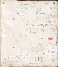
Summerside, P.E.I.: July 1903
Description: This is Page 5 of 11 pages of fire insurance maps of Summerside. It was created in 1903 and revised to 1910. It shows the area from Myrtle Street to Market Street North, between Duke and Central… more
Publisher: Chas. E. Goad, Civil Engineer
Province: Prince Edward Island
Type: fire insurance maps
Date Created: 1903-07
Date Modified: 1910
Date Issued (Source): 1888
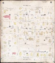
Summerside P.E.I.: July 1903.
Description: This is Page 6 of 11 pages of fire insurance maps of Summerside. It was created in 1903 and revised to 1910. It shows the area from Convent Street to Church Street, between Central and Granville… more
Publisher: Chas. E. Goad, Civil Engineer
Province: Prince Edward Island
Type: fire insurance maps
Date Created: 1903-07
Date Modified: 1910
Date Issued (Source): 1888
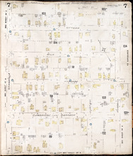
Summerside P.E.I.: July 1903.
Description: This is Page 7 of 11 pages of fire insurance maps of Summerside. It was created in 1903 and revised to 1910. It shows the area from Carvell Street to Belmont Street, between Granville and Russell… more
Publisher: Chas. E. Goad, Civil Engineer
Province: Prince Edward Island
Type: fire insurance maps
Date Created: 1903-07
Date Modified: 1910
Date Issued (Source): 1888
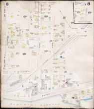
Summerside, P.E.I.: July 1903
Description: This is Page 8 of 11 pages of fire insurance maps of Summerside. It was created in 1903 and revised to 1917. It shows an area from the Kirk Street vicinity to the waterfront, east of Russell Street.… more
Publisher: Chas. E. Goad, Civil Engineer
Province: Prince Edward Island
Type: fire insurance maps
Date Created: 1903-07
Date Modified: 1917-08 (year and month uncertain)
Date Issued (Source): 1888
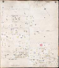
Summerside, P.E.I.: July 1903
Description: This is Page 9 of 11 pages of fire insurance maps of Summerside. It was created in 1903 and revised to either 1910 or 1917. It shows the area from Chestnut Avenue, in the north, to Myrtle and Convent… more
Publisher: Chas. E. Goad, Civil Engineer
Province: Prince Edward Island
Type: fire insurance maps
Date Created: 1903-07
Date Modified: 1910 (year uncertain)
Date Issued (Source): 1888