Displaying 1 - 5 of 5

Plan of Lot Thirty Seven: Queens Co., P.E.I.
Description: Map of Lot 37 and part of Lot 38. Map is from Meacham's 1880 PEI Historical Atlas. A few land conveyance references have been added in red ink. The map shows bodies of water such as rivers,… more
Province: Prince Edward Island
Type: cadastral maps
Date Created: 1880
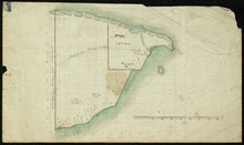
Part of Lot 38
Description: Plan of part of Lot 38 (No. 8). Coffin property. 220 acres of land bordering on Savage Harbour. The map shows the northwestern-most part of Lot 38 that is separated from the rest of the lot by Savage… more
Province: Prince Edward Island
Type: cadastral maps
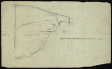
Part of Lot No. 38
Description: Plan of part of Lot 38 (No. 8), Coffin property. 220 acres of land bordering on Savage Harbour. The map shows the northwestern-most part of Lot 38 that is separated from the rest of the lot by Savage… more
Province: Prince Edward Island
Type: cadastral maps
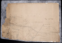
Plan of Lot No. 38 [? title partly missing]
Description: Plan of part of Lot 38 and part of Lot 39. Savage Harbour area. The map shows northern portions of Lot 38 and Lot 39 divided into parcels of land with names of residents and acreage amounts. It shows… more
Province: Prince Edward Island
Type: cadastral maps

Plan of Lot Thirty Seven : Plan of Lot Thirty Eight: Queens Co., P.E.I.. Kings Co., P.E.I.
Description: The map shows lot 37 (coloured in pink) in Queens county, and lot 38 (coloured in blue) in Kings county. Shown are roads, railroads, landowners and acreage, rivers, ponds, harbours, gulfs, creeks,… more
Publisher: J. H. Meacham & company
Province: Prince Edward Island
Type: cadastral maps
Date Issued (Source): 1880