Displaying 1 - 6 of 6
Plan of Cape Traverse Branch: Prince Edward Island Railway
Description: Canadian Government Railways, Prince Edward Island. Cape Traverse subdivision. Plans of the Railway right of way from Emerald Junction to Port Borden. Copied from the plans in the Engineer's… more
Province: Prince Edward Island
Type: cadastral maps
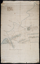
Plan-showing the Right of Way : Cape Traverse Branch P.E.I
Description: Plan showing the right of way of the Cape Traverse Branch of the Prince Edward Island Railway. The map shows roads, residents and acreage.
Province: Prince Edward Island
Type: cadastral maps
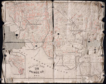
Plan of Lot 28: Prince Co. P.E.I.
Description: Printed map of Lot 28. Names and land conveyance references have been added in red ink. The map shows residents, lots, roads, bodies of water such as rivers, towns, and cities, buildings, and an… more
Province: Prince Edward Island
Type: cadastral maps
Eastern Division of Township No. 28
Description: Sketch of the eastern division of Lot 28 (No.33). DeBlois Estate.
Province: Prince Edward Island
Type: cadastral maps
Date Created: 1870-01-01
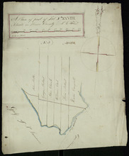
A Plan of part of Lot No. XXVIII. Situate in Prince County P. E. Island
Description: Plan of part of Lot 28 (No.3). The map shows 6 parcels of land with residents' names at Cape Traverse in Lot 28. The Northumberland Strait (which is labelled as the Gulf of St. Lawrence) is… more
Province: Prince Edward Island
Type: cadastral maps
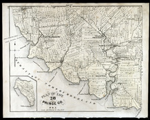
Plan of Lot 28: Prince Co., P.E.I.
Description: The map shows lot 28 in Prince county. Shown are straits, coves, rivers, Anglo-American cable, Winter Crossing Ice Boats, post offices, churches, landowners and acreage, and factories. Compass.
Publisher: J. H. Meacham & company
Province: Prince Edward Island
Type: cadastral maps
Date Issued (Source): 1880