Displaying 1 - 5 of 5
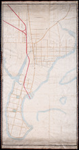
Unfinished plan of Alberton and Cascumpec Point, Lots 4 and 5
Description: Unfinished plan of Alberton and Cascumpec Point, Lots 4 and 5. Mainly outline. Shows churches, station ground, school, and the names of a few residents.
Province: Prince Edward Island
Type: cadastral maps
Paln No. 1 of Railway Appropriation: from Alberton to Tignish
Description: Plan of Railway Appropriations from Alberton to Tignish. (Plan No.1). The map shows roads, resdients, acreage, lots, and foliage.
Province: Prince Edward Island
Type: cadastral maps
Date Created: 1873
Plan No. 2 of Railway Appopriation: From Alberton to Tignish
Description: Plan of Railway Appropriations from Alberton to Tignish. (Plan No.2). The map shows roads, lots, residents, acreage, and foliage.
Province: Prince Edward Island
Type: cadastral maps
Date Created: 1873

Plan of Alberton: Surveyed by John Ball, Land Surveyor
Description: Plan of part of Alberton, Lot 4. Shows names of residents and land conveyance references, bodies of water such as bays, and creeks, and roads.
Province: Prince Edward Island
Type: cadastral maps
Date Created: 1871-08

Alberton, Prince Edward Island: Population 1500. Hand Engine. 400' Hose. Water Supply: Brook…
Description: This is a fire insurance plan of the town of Alberton concentrating on two blocks of Main Street from Church Street to Argyle Street. A key plan in the lower left corner provides context. The map was… more
Publisher: Chas. E. Goad, Civil Engineer
Province: Prince Edward Island
Type: fire insurance maps
Date Created: 1888-10
Date Modified: 1910-10
Date Issued (Source): 1888