Displaying 460 - 486 of 603
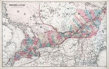
Dominion of Canada: (Western Sheet)
Description: Map showing the province of Ontario, and Quebec. Shows rivers, lakes, channels, bays, roads, railroads, cities, towns, copper mines, and sea measurements. Ontario and Quebec are coloured and cities… more
Publisher: J. H. Meacham & company
Province: Ontario, Quebec, Prince Edward Island, Michigan, New York, Ohio
Type: cadastral maps
Date Issued (Source): 1880
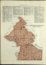
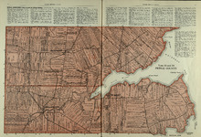
Princetown Royalty: Prince County
Description: The map shows Princetown Royalty in Prince County. Shown are rivers, bays, roads, landowners, acreage, and towns. Atlas of Province of Prince Edward Island, Canada and the World
Publisher: Cummins Map Co.
Province: Prince Edward Island
Type: cadastral maps
Date Issued (Source): 1927
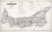
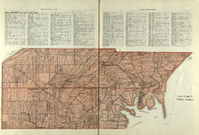
Map of the Province of Prince Edward Island: in the Gulf of St. Lawrence
Description: The map shows the province of Prince Edward Island. Shown are tables of Explanations and Electorial Districts, a compass and the county lines are marked in red. Shown are gulfs, straits, bays, reefs… more
Publisher: J. H. Meacham & company
Province: Prince Edward Island
Type: cadastral maps
Date Created: 1880
Date Issued (Source): 1880
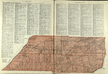
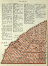
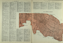
Lots 2 & 3 : Prince County
Description: The map shows lots 2 & 3 in Prince county. Shown are the Gulf of St. Lawrence, capes, ponds, landowners, acreage, rivers, and roads.
Publisher: Cummins Map Co.
Province: Prince Edward Island
Type: cadastral maps
Date Issued (Source): 1927
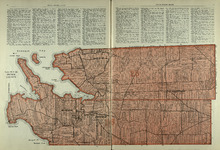
Lots 4 : Prince county
Description: The map shows Lots 4
Publisher: Cummins Map Co.
Province: Prince Edward Island
Type: cadastral maps
Date Issued (Source): 1927

Plan of Lot One: Prince Co., P.E.I.
Description: Map showing the northWestern tip of the island. It names the gulfs, rivers, ponds, landowners and acreage, roads, and railroads. A graphic compass.
Publisher: J. H. Meacham & company
Province: Prince Edward Island
Type: cadastral maps
Date Issued (Source): 1880
Lot No. 7: Prince County
Description: The map shows Lot 7 in Prince county. Shown are capes, coves, roads, landowners, and acreage.
Publisher: Cummins Map Co.
Province: Prince Edward Island
Type: cadastral maps
Date Issued (Source): 1927

Plan of Lot Six: Prince Co., P.E.I.
Description: Map showing lot six, bordering lots 5, 9, 10, 11 in Prince county. Shows rivers, creeks, railroads, roads, landowners, acreage, post offices, and buildings. Geographical compass
Publisher: J. H. Meacham & company
Province: Prince Edward Island
Type: cadastral maps
Date Issued (Source): 1880
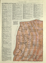
Lot No. 8: Prince County
Description: The map shows Lot 8 in Prince County. Shown are the Nothumberland Strait, Wolf Inlet, Landowners, acreage, and roads.
Publisher: Cummins Map Co.
Province: Prince Edward Island
Type: cadastral maps
Date Issued (Source): 1927

Plan of Lots Two : Prince Co., P.E.I.
Description: Map showing lots 2
Publisher: J. H. Meacham & company
Province: Prince Edward Island
Type: cadastral maps
Date Issued (Source): 1880

Lot No. 9: Prince County
Description: The map shows Lot 9 in Prince county. Shown are roads, Egmont Bay, Dog Cove, roads, and railroads.
Publisher: Cummins Map Co.
Province: Prince Edward Island
Type: cadastral maps
Date Issued (Source): 1927

Plan of Lot Seven: Prince Co., P.E.I.
Description: Map showing lot seven, bordering lots 4, 5, 6, and 8 in Prince county. Shows gulfs, railroads, roads, landowners, acreage, post offices, and buildings. Geographical compass
Publisher: J. H. Meacham & company
Province: Prince Edward Island
Type: cadastral maps
Date Issued (Source): 1880

Tignish, Prince Co.: Campbellton
Description: The map shows Lot 1 in Tignish, Prince county. Shown are roads, landowners and acreage, a church, chapel, and convent, a cemetery, railroad and station, grammar school, business, and houses. Compass.
Publisher: J. H. Meacham & company
Province: Prince Edward Island
Type: cadastral maps
Date Issued (Source): 1880
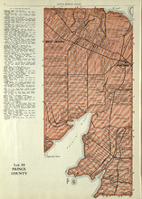
Lot 10: Prince County
Description: The map shows Lot 10 in Prince county. Shown are rivers, roads, landowners, and acreage.
Publisher: Cummins Map Co.
Province: Prince Edward Island
Type: cadastral maps
Date Issued (Source): 1927
Lot 11: Prince County
Description: The map shows lot 11 in Prince county. Shown are roads, landowners, acreage, the Gulf of St. Lawrenece, Sand Hills, The Narrows, Cascumpeque Baym Foxley River, and Cavendish Inlet.
Publisher: Cummins Map Co.
Province: Prince Edward Island
Type: cadastral maps
Date Issued (Source): 1927
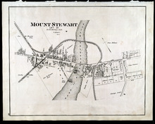
Mount Stewart: Lot 37
Description: The map shows lot 37 in Mount Stewart. Shown are roads, railroads and depot, landowners, houses, churches, Hillsborough river, wharfs, halls, and shipyard. Compass.
Publisher: J. H. Meacham & company
Province: Prince Edward Island
Type: cadastral maps
Date Issued (Source): 1880
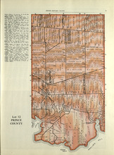
Lot 12: Prince County
Description: The map shows Lot 12 in Prince county. Shown are roads, landowners, acreage, The Narrows, rivers, and a railroad.
Publisher: Cummins Map Co.
Province: Prince Edward Island
Type: cadastral maps
Date Issued (Source): 1927

Plan of Lot Four : Prince Co., P.E.I.
Description: Map showing lots four
Publisher: J. H. Meacham & company
Province: Prince Edward Island
Type: cadastral maps
Date Issued (Source): 1880
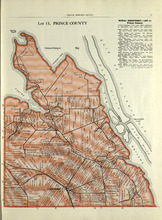
Lot 15: Prince County
Description: The map shows lot 15 in Prince county. Shown are Red Head, Cape Egmont, Egmont Bay, the Northumberland Strait, rivers, landowners, acreage, and roads.
Publisher: Cummins Map Co.
Province: Prince Edward Island
Type: cadastral maps
Date Issued (Source): 1927

Plan of Lot Eight: Prince Co., P.E.I.
Description: The map shows lot 8 in Prince county. Shown are roads, landowners and acreage, rivers, Northumberland strait, ponds, lighthouses, post offices, churches, mills, and businesses. Compass.
Publisher: J. H. Meacham & company
Province: Prince Edward Island
Type: cadastral maps
Date Issued (Source): 1880
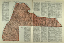
Lots 14 and 16 : Prince County
Description: The map shows lots 14 and 16, in Prince county. Shown are bays, ponds, coves, landowners, acreage, rivers, and roads.
Publisher: Cummins Map Co.
Province: Prince Edward Island
Type: cadastral maps
Date Issued (Source): 1927

Plan of Lot Thirteen: Prince Co., P.E.I.
Description: Map showing lot thirteen, bordering lots 12, 14 and 15, in Prince county. Shows gulfs, straits, bays, rivers, ponds, creeks, railroads, roads, landowners, acreage, post offices, and buildings.… more
Publisher: J. H. Meacham & company
Province: Prince Edward Island
Type: cadastral maps
Date Issued (Source): 1880
Lot 17: Prince County
Description: The map shows Lot 17 in Prince county. Shown are byas, coves, landowners, acreage, towns, cities, and roads.
Publisher: Cummins Map Co.
Province: Prince Edward Island
Type: cadastral maps
Date Issued (Source): 1927

Plan of Lot Nine: Prince Co., P.E.I.
Description: The map shows lot 9 in Prince county. Shown are roads, landowners and acreage, Egmont bay, sand, Brae river, post offices, railroad and station, schools and churches. Compass.
Publisher: J. H. Meacham & company
Province: Prince Edward Island
Type: cadastral maps
Date Issued (Source): 1880

Plan of Lot Fourteen & Sixteen : Prince Co., P.E.I.
Description: Map shows lots fourteen & sixteen in Prince county. Shown are roads, creeks, coves, rivers, post offices, railroads and stations, ferries, points, bays, landowners, acreage, churches, and… more
Publisher: J. H. Meacham & company
Province: Prince Edward Island
Type: cadastral maps
Date Issued (Source): 1880

Plan of Lot Ten: Prince Co., P.E.I.
Description: The map shows lot 10 in Prince county. Shown are roads, rivers and creeks, railroad and station, post offices, a school, and landowners and acreage. Compass.
Publisher: J. H. Meacham & company
Province: Prince Edward Island
Type: cadastral maps
Date Issued (Source): 1880
Lots 25 & 26 : Prince County
Publisher: Cummins Map Co.
Type: cadastral maps
Date Issued (Source): 1927