Displaying 109 - 118 of 118
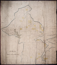
A Plan of Prince Town Royalty: from A Survey made in Nov. 1828
Description: A plan of Prince Town Royalty. Also shows Prince Town. Gives numbers of Town and Royalty Lots. The map shows bodies of water, squares, and towns.
Province: Prince Edward Island
Type: cadastral maps
Date Created: 1828-11
Prince Edward Island Railway
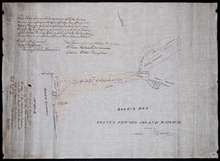
Description: Prince Edward Island Railway. Land appropriated at Souris. This plan shewing the lands appropriated by the Railway Commissioners is filed in the Office of Registar of Deeds and Keeper of Plans for… more
Province: Prince Edward Island
Type: cadastral maps
Date Created: 1874
Plan showing land at Souris appropriated for the Railway : Plan signed by O. Curtis, Registrar of…
Description: Plan showing land at Souris appropriated for the Railway. Plan signed by O. Curtis, Registrar of Deeds. Shown are residents, and railroad tracks.
Province: Prince Edward Island
Type: cadastral maps
Date Created: 1879-06-18
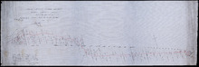
Prince Edward Island Railway Murray Harbour Branch: Plan of extension from Murray River to Murray…
Description: Prince Edward Island Railway. Murray Harbour Branch. Plan of extension from Murray River to Murray Harbour. Produced by Wm. B. MacKenzie, Chief Engineer. The map shows lots, residents, acreage and… more
Province: Prince Edward Island
Type: cadastral maps
Date Created: 1906-05-31
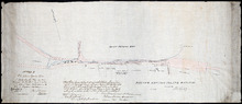
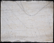
This Plan shewong the land appropriated by the Railway Commissioners is filed in th Office of the…
Description: Prince Edward Island Railway. Railway appropriation at St. Peter's Bay. (No.5) (Also, No. 238A). The map shows lots, roads, residents, and St. Peter's Bay. more
Province: Prince Edward Island
Type: cadastral maps
Date Created: 1874
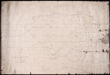
Office Copy of Plan No. 5 of the Royalty of George Town: by Jos. Ball D. S. Gl. June 7th 1853
Description: The map shows the numbered town lots and street grid of Georgetown. It gives the acreage amounts of a few of the town lots. The names of some residents have been added in pencil. The map shows… more
Province: Prince Edward Island
Type: plans
Date Created: 1853-06-07

Tracing of the right of way for the Prince Edward Island Railway into Georgetown.
Description: Tracing of the right of way for the Prince Edward Island Railway into Georgetown.
Province: Prince Edward Island
Type: cadastral maps
Paln No. 1 of Railway Appropriation: from Alberton to Tignish
Description: Plan of Railway Appropriations from Alberton to Tignish. (Plan No.1). The map shows roads, resdients, acreage, lots, and foliage.
Province: Prince Edward Island
Type: cadastral maps
Date Created: 1873
Plan No. 2 of Railway Appopriation: From Alberton to Tignish
Description: Plan of Railway Appropriations from Alberton to Tignish. (Plan No.2). The map shows roads, lots, residents, acreage, and foliage.
Province: Prince Edward Island
Type: cadastral maps
Date Created: 1873
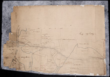
Plan of Lot No. 38 [? title partly missing]
Description: Plan of part of Lot 38 and part of Lot 39. Savage Harbour area. The map shows northern portions of Lot 38 and Lot 39 divided into parcels of land with names of residents and acreage amounts. It shows… more
Province: Prince Edward Island
Type: cadastral maps