Displaying 136 - 162 of 220
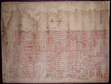
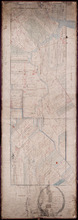
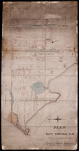
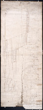
Eastern Moiety of Township No. 20
Description: Plan of the eastern moiety of Lot 20. Color code shows property of William Cundall, Louisa Montgomery, Eliza M. Cundall and Henry J. Cundall. Cundall Estate (No.51). Shows names of residents and… more
Province: Prince Edward Island
Type: cadastral maps
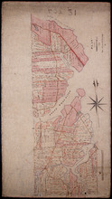
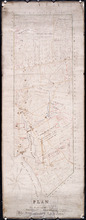
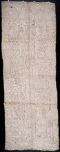
Plan of part of Lot 21: No. 55
Description: The map shows the southern portion of Lot 21 divided into parcels of land with the names of resident and their acreage amounts. Some parcels are outlined in red. Land conveyance information appears… more
Province: Prince Edward Island
Type: cadastral maps
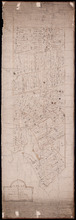
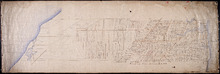
Plan of part of Township No. 21: Copied from a Plan of H,J, Cundall's
Description: Plan of the northern part of Lot 21 (No.57). Cunard Estate. Shows names of residents, acreage, and some land conveyance references, bodies of water such as rivers, and the Gulf of Saint Lawrence,… more
Province: Prince Edward Island
Type: cadastral maps
Part of Township No. 21: in Prince Edward Island
Description: Plan of the southern half of Lot 21. One of the plans referred to in the Deed from Sir Edward, William and Laura Cunard to the Commissioner of Public Land, July 13, 1866. Shows names of residents,… more
Province: Prince Edward Island
Type: cadastral maps
Plan of the Estate of D.S. Rennie Esqr. on Lot No. 23 in Queens County Prince Edward Island: As…
Description: The map shows a southern portion of Lot 23 divided into numbered parcels of land with the names of residents and their acreage amounts. Some parcels are coloured green. The map also shows the land… more
Province: Prince Edward Island
Type: cadastral maps
Date Created: 1863
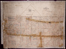
Plan of Township No. 23
Description: Plan of Lot 23. Shows the estates of Susan Rennie, David S. Rennie and Daniel Hodgson. Gives names of residents, acreage, and a few land conveyance references, rivers, gulfs, roads, towns, and a… more
Province: Prince Edward Island
Type: cadastral maps
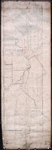
Plan of Part of Lot or Township No.23 in grenville Parish in Queens County, Prince Edward Island
Description: Plan of part of Lot 23 (No.61). The estate of David Rennie. Shows names of residents, acreage, and some land conveyance references, rivers, and roads.
Province: Prince Edward Island
Type: cadastral maps
Date Created: 1864-05
Plan of Lot 27 Prince County: The Property of James P.
Description: Plan of the northern part of Lot 27 (No.72). Pope Estate. Shows names of residents and acreage, the Northumberland Strait, mill pond, and roads. Plan referred to in the Deed from Pope to the… more
Province: Prince Edward Island
Type: cadastral maps
Plan of Part of the Estate of R.B. Stewart Esq. Situate on Lot or Township No. 27 shewing the…
Description: Plan of part of Lot 27. Estate of R.B. Stewart. Shows names of residents, acreage, and a few land conveyance references, roads, and the sea shore.
Province: Prince Edward Island
Type: cadastral maps
Date Created: 1848-03-24
A Plan of Part of Lot No. XXVII Situat in P.E.I. the Property of J. Cambridge Esq. from an Actual…
Description: Plan of part of Lot 27 (No.74). The property of J. Cambridge. Shows names of residents and acreage, Carlton Cove and a compass. Plan is one of those referred to in the Deed from Sir Edward, William… more
Province: Prince Edward Island
Type: cadastral maps
Date Created: 1828-08
Plan of the Western Moriety of Township No. 29: The Estate of The honorable Lady Fane
Description: Plan of the western moiety of Lot 29 (No.78). The estate of the Hon. Lady Fane. Shows names of residents, acreage, and a few land conveyance references, bodies of water such as the Gulf of St.… more
Province: Prince Edward Island
Type: cadastral maps
A Plan of the Western Moriety of Township Number 29: The property of Colonel The Hon. H.S. Fane…
Description: Plan of the western moiety of Lot 29 (No.81). Property of Colonel the Hon. H.S. Fane. Shows names of residents, acreage, and roads. Signed by Owen Curtis, Land Surveyor.
Province: Prince Edward Island
Type: cadastral maps
Copy of Plan of part of Lot 27 Prince County P.E.I. Purchased from Hon. J. C. Pope
Description: Copy of plan of part of Lot 27 purchased from Hon. J.C. Pope. The plan is referred to in the Deed from James Colledge Pope and his wife to the Commissioner of Public Lands, July 13, 1868. The map… more
Province: Prince Edward Island
Type: cadastral maps
Date Created: 1868
Plan of Part Township No. 28: The property of Henry Palmer Esquire
Description: Plan of part of Lot 28 (No.75). The property of Henry Palmer. Shows names of residents, acreage , and land conveyance references, bodies of water such as marshes, straits, and rivers, roads,… more
Province: Prince Edward Island
Type: cadastral maps

Plan of Alberton: Surveyed by John Ball, Land Surveyor
Description: Plan of part of Alberton, Lot 4. Shows names of residents and land conveyance references, bodies of water such as bays, and creeks, and roads.
Province: Prince Edward Island
Type: cadastral maps
Date Created: 1871-08
Plan of Township No. 3: Copied from Mr. Andersons Plan 1847 by Geo. Wright
Description: Plan of Lot 3 showing the Township divided into 21 lots. Plan copied by Geo. Wright. The map shows names of residents, acreage, roads, rivers, and capes.
Province: Prince Edward Island
Type: cadastral maps
Date Created: 1847
Plan of Lot 2 (No.7)
Description: Plan of Lot 2 (No.7). Cunard Estate. The map shows residents, and acreage, bodies of water, roads, and a division line.
Province: Prince Edward Island
Type: cadastral maps
Plan of Lot 2
Description: Plan of Lot 2 showing names of residents, acreage, and some land conveyance references, rivers, and roads.
Province: Prince Edward Island
Type: cadastral maps

Plan of Lot 2
Description: Plan of Lot 2. Plan referred to in the deed from Sir Edward, William and Laura Cunard to the Commissioner of Public Lands. Shows names of some residents, also gives some land conveyance references,… more
Province: Prince Edward Island
Type: cadastral maps
Date Created: 1866
Plan of the Western Moiety of Lot or Township 1 : Part of ot copied and part from actual survey by…
Description: Plan of the western moiety of Lot 1 (No.2), part of it copied and part from actual survey. Palmer Estate. The map shows residents and land acreage, ponds, and roads.
Province: Prince Edward Island
Type: cadastral maps
Date Created: 1854-08-05

Plan of Township No. 2: Compiled from the Proprietors Plans and partial surveys
Description: Plan of Lot 2 (No.5). Compiled from the Proprietors Plans and partial surveys by John Ball, Public Lands Department. Cunard Estate. Shows the names of residents, former occupants, and land conveyance… more
Province: Prince Edward Island
Type: cadastral maps
Date Created: 1885-10
Plan of Lot 54. Incomplete.
Description: Plan of Lot 54. Incomplete. Shows names of some residents, lots, acreage, roads, and bodies of water such as creeks.
Province: Prince Edward Island
Type: cadastral maps
Plan of Lot 54
Description: Plan of Lot 54. Shows names of residents, lots, roads, and bodies of water such as rivers.
Province: Prince Edward Island
Type: cadastral maps
A Plan showing the Position of the Line of Road through, proposes to be run through Lot 47 from…
Description: Plan of existing and proposed road through Lot 47 from George Munn's, West River, to the bridge on the north side of Surveyor's Pond. Distance of 4 miles and 2 chains. Road run under the… more
Province: Prince Edward Island
Type: cadastral maps
Date Created: 1851-08
Partial plan of Lot 48
Description: Partial plan of Lot 48. Mainly outline. Shows names of some residents in southern half of Lot. The map shows residents and lots, and roads.
Province: Prince Edward Island
Type: cadastral maps

Plan of Murray River Lot 63: North of the River
Description: Plan of part of Murray River, Lot No.63. Area north of the River and west of Main Street. The map shows residents, lots, acreage, roads, towns, and a nautical compass.
Province: Prince Edward Island
Type: cadastral maps
Date Created: 1958

Plan showing the situation of the line of road from Melville Road to Appin Road also the connecting…
Description: Plan showing the situation of the line of road from Melville Road to Appin Road; also, the connecting road leading to Crapaud Wharf. Roads pass through Lots 29 and 30. (No.15, Queen's). Shown… more
Province: Prince Edward Island
Type: cadastral maps
Date Created: 1868-06-08