Displaying 28 - 54 of 220
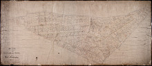
Plan of Railway appropriations in Lots 26, 27 and 28
Description: Plan of Railway appropriations in Lots 26, 27 and 28. The map shows lots, roads, residents, and acreage.
Province: Prince Edward Island
Type: cadastral maps, transportation maps
P.E.I. Railway: Elmira Branch Plan of Right-of-Way
Description: Prince Edward Island Railway. Elmira Branch. Plan of Right-of-Way (No.429, Kings Co.). Plan created by Wm. B. MacKenzie, Chief Engineer. The map shows lots, roads, residents, and acreage.
Province: Prince Edward Island
Type: cadastral maps
Date Created: 1909-06-02

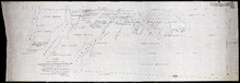
Plan of Part of the Railway Line on Lots No 17.
Description: Plan of part of the Railway Line on Lot 17. Appropriations from the French Purchase to the Linkletter Road. The map shows roads, residents and acreage.
Province: Prince Edward Island
Type: cadastral maps, transportation maps
Date Created: 1872-04-29
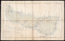
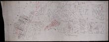
Railway appropriations from Hunter River to Clyde Station: Lots 22 and 23
Description: Railway appropriations from Hunter River to Clyde Station. Lots 22 and 23. The map shows residents and acreage, roads, stations, ponds, and foliage.
Province: Prince Edward Island
Type: cadastral maps
Date Created: 1872
Plan-showing the Right of Way : Cape Traverse Branch P.E.I
Description: Plan showing the right of way of the Cape Traverse Branch of the Prince Edward Island Railway. The map shows roads, residents and acreage.
Province: Prince Edward Island
Type: cadastral maps

Plan Alterations of Railway on Lot 17 and Station Grounds at Summerside.
Description: Plan of Alterations of the Railway on Lot 17 and the Station Grounds at Summerside. The map shows lots, residents, streets, wharfs, and buildings.
Province: Prince Edward Island
Type: cadastral maps
Date Created: 1872-10-10

Topographical map of Prince Edward Island
Description: Topographical map of Prince Edward Island. Map has been cut into sections and pieced together. Therefore scale, date, etc. is missing. The maps shows mulitple bodies of water, counties, roads, towns… more
Province: Prince Edward Island
Type: cadastral maps

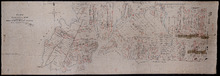
Plan of Township No. 67, and its environs.: Compiled from Surveys by Geo. Wright; H.J. Cundall;…
Description: Plan of Lot 67 and its environs. Compiled from surveys by Geo. Wright, H.J. Cundall, Joseph Ball, and Owen Curtis. Drawn by Thomas MacKinlay. Shows names of some residents, roads, railroads, bodies… more
Province: Prince Edward Island
Type: cadastral maps
Date Created: 1877-08-01

Stanhope Shore Rd.
Description: The map shows the Stanhope Shore Road with the names of residents, their road frontage measurements and dollar amounts for each.
Province: Prince Edward Island
Type: cadastral maps
Date Created: 1954
Plan of the Cunard and Palmer Estates in Lot or Township No.1.
Description: Plan of Lot 1 (No.1). Cunard and Palmer Estates. Drawn by Owen Curtis. Shows names of residents, acreage, and a few land conveyance references, and roads.
Province: Prince Edward Island
Type: cadastral maps

Plan of Township No. 63: compiled from the proprietors' plans, descriptions in leases and…
Description: Plan of Lot 63 compiled from the proprietors' plans, descriptions in leases and registered deeds, and from Meacham's Atlas, with additions and corrections from surveys made at various times… more
Province: Prince Edward Island
Type: cadastral maps
Date Created: 1921-02

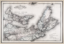
Geological Map of Canada and Newfoundland: Derive from the Results of The Canadian Geological…
Description: Framed map of Canada and Newfoundland. The map is has colours for different land marks, and a table that explains it all. Shown are bodies of water such as rivers, islands, roads, towns, and cities.
Province: Newfoundland, New Brunswick, Prince Edward Island, Nova Scotia, Quebec
Type: geological maps
Date Created: 1866 (year uncertain)
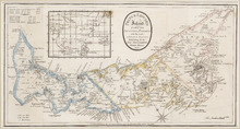
Prince Edward Island: divided into Counties & Parishes, with the Lots, as Granted by Government…
Description: Prince Edward Island divided into Counties and Parishes with the Lots as granted by Government, exhibiting all the New Settlements, Roads, Mills, etc. Published by H. Ashby, King Street, Cheapside,… more
Publisher: Ashby, H.
Province: Prince Edward Island
Type: cadastral maps
Date Created: 1798-03-01

Office copy of that part of the Plan of the new line of Road leading from the Cardigan River to the…
Description: Plan of the new line of road leading from the Cardigan River to the Hillsborough River. Passes through Lots 51, 52, and 38. Plan copied by Geo. Wright, 12 August, 1837. The plan uses a dashed and… more
Province: Prince Edward Island
Type: engineering maps
Date Created: 1833
Plan of land appropriated by the Railway Commissioners in Lots 38 and 51
Description: Prince Edward Island Railway. Plan shows the land appropriated by the Railway Commissioners in Lots 38 and 51. The rail line is drawn in pink. Roads are shown in a lighter colour. Names of residents… more
Province: Prince Edward Island
Type: engineering maps
Plan of Île Saint-Jean: The Island of Saint John
Description: Plan of Ile Saint-Jean / the Island of Saint John. The map shows Prince Edward Island and a portion of the mainland. It identifies settlements, bays, harbours, rivers and islands. Sandy areas are… more
Province: Prince Edward Island
Type: topographic maps
Date Created: 1760
New Railway and Postal Map of the Dominion of Canada, Sheet No. 2
Description: Framed map shows the post offices, money order offices, P.O. saving offices, telegraph sections, ports of entry, railways and the distance between towns over post roads of the time. Prince Edward… more
Province: Prince Edward Island
Type: geological maps
Date Created: 1880

Map of Prince Edward Island in the Gulf of St. Lawrence: for McGregor's British America
Publisher: Ballantyne and Company
Province: Prince Edward Island
Type: cadastral maps, topographic maps
Date Created: 1832
Plan of Lot 50
Description: Plan of Lot 50. Shows names of residents, acreage, and some land conveyance references, roads, and bodies of water such as rivers (Orwell), and bays (Pownal).
Province: Prince Edward Island
Type: cadastral maps

Plan of Township No. 55: Compiled from the plans on file in the Land and Registry Offices, from the…
Description: Plan of Lot 55 compiled from the plans on file in the Land and Registry Offices, from the descriptions in the registered Grants and from Meacham's Atlas. Shows names of residents, acreage, and… more
Province: Prince Edward Island
Type: cadastral maps
Date Created: 1919

Township No. Fiftyfour. St. Georges Parish. Kings County. Prince Edward Island.: Chiefly from…
Description: Plan of Lot 54 (No.145). Shows names of residents, acreage, and some land conveyance references. Copied by H.J. Cundall. Certified plan. The map also shows bodies of water such as rivers (Cardigan),… more
Province: Prince Edward Island
Type: cadastral maps
Plan of the Estate of the Hon. Spencer Cecil Brabazon Ponsonby Fane Situate on Lot or Township No.…
Description: Plan of Lot 53 showing the estate of the Hon. Spencer Cecil Brabazon Ponsonby Fane. Copied by R.T. Weeks. Shows names and acreage of some residents, roads, and rivers such as Morell.
Province: Prince Edward Island
Type: cadastral maps

Plan of Lot or Township No. 51 in Kings County P. E. Island
Description: Plan of Lot 51 (No.139) Colour code shows freehold and unsold portions. Sir Graham Montgomery Estate. Shows names, acreage, and land conveyance references of some residents, and roads.
Province: Prince Edward Island
Type: cadastral maps
Plan of Township No. 50, the Property of Maria Susanna Matilda Fanning
Description: Plan of Lot 50, the property of Maria Susanna Matilda Fanning. Shows names of residents, acreage, and land conveyance references, bodies of water such as rivers (Vernon), bays (Pownal), and roads.… more
Province: Prince Edward Island
Type: cadastral maps

Plan of Part of Township No. 49. Bedford Parish. Queens County. P. E. Island.
Description: Plan of part of Lot 49 (No.135). One of the plans referred to in the deed from Sir Edward, William, and Laura Cunard to the Commissioner of Public Lands, July 13, 1866. The portion of land intended… more
Province: Prince Edward Island
Type: cadastral maps
Date Created: 1850
Plan of part of Lot 50
Description: Plan of part of Lot 50 (No.13). Area east of the Murray Harbour Road, north of the Dundee Road, and south of Georgetown Road. Shows names of residents.
Province: Prince Edward Island
Type: cadastral maps