Displaying 82 - 108 of 171
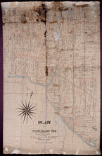
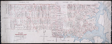
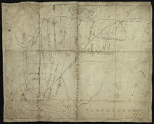
Plan of Township No. 9: Copied from plan furnished by Proprietress with alterations and additions…
Description: Plan of Lot 9 (No.26). Sullivan Estate. Copied from plan furnished by Proprietress with alterations and additions from surveys by Owen Curtis, John Clay &c. Shows names of residents, acreage, and… more
Province: Prince Edward Island
Type: cadastral maps
Date Created: 1883-08-18
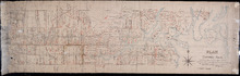
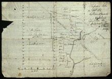
Lot 9
Description: Plan of Lot 9 (No.25). Sullivan Estate. Shows names of residents, acreage, and land conveyance references, rivers, roads, and Sandy or Brae Islands.
Province: Prince Edward Island
Type: cadastral maps
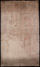
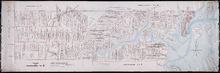
Plan of Township No. 9 in Prince Edward Island: The Property of Miss Charlotte Sullivan containing…
Description: Plan of Lot 9 (No.27). The property of Miss Charlotte Sulivan, containing 17300 acres. Shows names of residents and acreage, bodies of water such as rivers, creeks, roads, Sandy or Brae Island, and… more
Province: Prince Edward Island
Type: cadastral maps
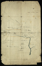
Lot 8
Description: Plan of the eastern part of Lot 8 (No.24). Ramsay Estate. Shows names of some residents, acreage, and some land conveyance references, rivers, roads, and sand hills.
Province: Prince Edward Island
Type: cadastral maps
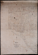
Plan of Township No. 6: Compiled from plans, leases, deeds, and other documents on file in the Land…
Description: The map shows Lot 6 divided into parcels of land with names of residents, their acreage amounts and land conveyance references handwritten in black and red ink. Shows the P.E.I. Railway in red, roads… more
Province: Prince Edward Island
Type: cadastral maps
Date Created: 1912-01
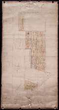
Plan of Township No. 5: compiled from plans, leases, deeds, and other documents on file in the Land…
Description: Plan of Lot 5 compiled from plans, leases, deeds, and other documents on file in the Land Office. The map shows Lot 5 divided into parcels of land with names of residents, their acreage amounts and… more
Province: Prince Edward Island
Type: cadastral maps
Date Created: 1911-09

Plan of Lot or Township No. 5 in Prince Edward Island: The Shore and the Division line, coloured…
Description: Plan of Lot 5. The Shore and the Division line, coloured Yellow are according to actual Survey by A. Anderson. Shows names of residents, acreage, and land conveyance references, bodies of water such… more
Province: Prince Edward Island
Type: cadastral maps
Date Created: 1840
Plan of Township No. 5: Copied from Plans in Land Office, with many addition and corrections from…
Description: Plan of Lot 5 (No.17). Cunard Estate. Copied from plans in Land Office with many additions and corrections from more recent surveys. Also sundry data connecting the lands with their ledger folios,… more
Province: Prince Edward Island
Type: cadastral maps
Date Created: 1886
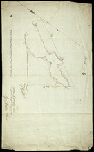
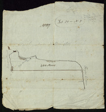
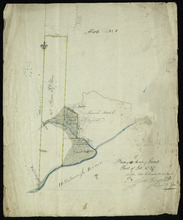
Plan of 500 Acres Land in Egmont Bay 7th February 1814
Description: The map shows 500 acres of land around the mouth of the Haldimand River in Egmont Bay, northeast of Cape Egmont. Plan of part of Lot 15 (No.4).
Province: Prince Edward Island
Date Created: 1814-02-07
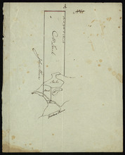
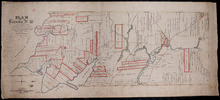
Lot 28 -- No. 2
Description: Plan of part of Lot 28 (No.2). The map shows 200 acres of land along the Northumberland Strait between Crapuad Creek and the Tryon River in Lot 28. Areas that appear to be marshes are indicated with… more
Province: Prince Edward Island
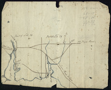
Part of Lots 28 and 29
Description: Plan of part of Lots 28 and 29 (No.9). The maps shows the area around the Tryon and Westmoreland (or Crapaud) rivers in Lots 28 and 29. It gives the names of a few residents and shows several roads,… more
Province: Prince Edward Island
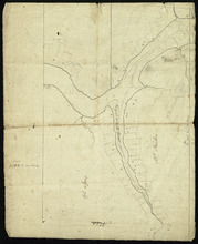
Entrance to the Croppo River
Description: Plan of part of Lot 29 (No.4). Entrance to Croppo River. Shows soundings at Crapaud Harbour. The map shows the harbour and entrance to the Crapaud (or Westmoreland) River. Soundings appear to be… more
Province: Prince Edward Island
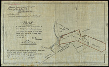
Plan of 117 ½ Acres of Land in the possession of James C. Wright together with several adjoining…
Description: Plan of part of Lot 29. 117½ acres of land in the possession of James C. Wright together with several adjoining tracts. Traced from original unsigned plan of Mr Clay by Thos. MacKinlay, June 17, 1882… more
Province: Prince Edward Island
Type: cadastral maps
Date Created: 1879-11-28
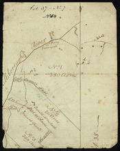
Refugee Lots on Lot 32 Prince Edward Island: Copied from the Original Plan
Description: Plan of Refugee Lots on Lot 32. Copied from the original. The map shows a northern portion of Lot 32 divided into numbered refugee lots, each 100 acres in size. It gives the names of some residents,… more
Province: Prince Edward Island
Type: cadastral maps
Date Created: 1809
Part of Lot 32: Refugee Lots
Description: Plan of part of Lot 32 (No.4). Refugee Lots. The map shows a northern part of Lot 32 that was divided into refugee lots. It gives the names of residents and acreage amounts for some. The map shows a… more
Province: Prince Edward Island
Type: cadastral maps
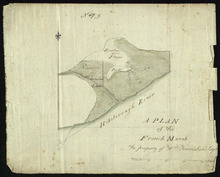
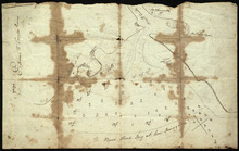
A Plan of the French Marsh: the property of Wm. Townshend. Esqr.
Description: Plan of part of Lot 37 (No.9). The French Marsh. The map shows a marsh area belonging to William Townshend on the north side of the Hillsborough River in Lot 37. Marsh area is shaded and coloured… more
Province: Prince Edward Island
Type: cadastral maps, topographic maps
Lot 37 - No. 7
Description: Plan of part of Lot 37 (No. 7). Area south of the Hillsborough River. The maps shows a small area on the south side of the Hillsborough River in Lot 37 adjacent to the boundary with Lot 38. It shows… more
Province: Prince Edward Island
Type: cadastral maps
Plan of 150 Acres of Land Part of Lot No. 37.
Description: Plan of part of Lot 37 (No. 8). 150 acres of land, the property of John Stowe. The map shows a parcel of land, approximately 150 acres in size, outlined in yellow, on the north side of the… more
Province: Prince Edward Island
Type: cadastral maps
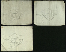
Plan of the French Marsh: Lot 37 - No. 10
Description: Plan of part of Lot 37 (Nos. 10 and 58). This item consists of three maps on three separate sheets, all showing the same area. The maps show the French Marsh on the north side of the Hillsborough… more
Province: Prince Edward Island
Type: cadastral maps, topographic maps
Lot 37 - No. 12
Description: Plan of part of Lot 37 (No. 12). The Pisquid or Hill River area. Outline. The map shows the area where the Pisquid (or Hill) River joins the Hillsborough River in Lot 37. It gives the names of some… more
Province: Prince Edward Island
Type: cadastral maps, topographic maps
Part of Lot 37
Description: Plan of part of Lot 37 (No. 13). Property of Mr. Leech.[?] The map shows a parcel of land on the north side of the Hillsborough River in Lot 37. It gives the names of two residents. The map shows the… more
Province: Prince Edward Island
Type: cadastral maps
Part of Lot 38: No. 14
Description: Plan of part of Lot 38 (No. 14). Capt. Bentinck's land. The map shows a parcel of land belonging to Captain Bentinck, north of the Hillsborough River in Lot 38. It gives names of residents and… more
Province: Prince Edward Island
Type: cadastral maps
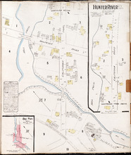
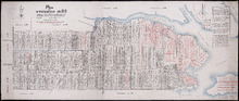
Hunter River P.E.I. Kings Co.: Population 150. No Protection. Oct. 1910.
Description: This is a fire insurance plan of Hunter River. It shows the town in two (2) sections that are intended to be continuous. The sections show the area around the California Road and the Malpeque Raod. A… more
Publisher: Chas. E. Goad, Civil Engineer
Province: Prince Edward Island
Type: fire insurance maps
Date Created: 1910-10
Date Issued (Source): 1888
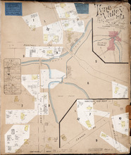
Tyne Valley P.E.I.: Novr. 1897. 1 Mile West of Port Hill Station. Population 300. No Appliances.…
Description: This is a fire insurance plan of Tyne Valley. It was created in 1897, revised to 1903, and then revised again to October, 1910. It shows the town in two (2) sections that are intended to be… more
Publisher: Chas. E. Goad, Civil Engineer
Province: Prince Edward Island
Type: fire insurance maps
Date Created: 1897-11
Date Modified: 1903-07, 1910-10
Date Issued (Source): 1888
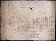
Plan of 1390 Acres of Land part of Township No. 65: The Property of the Honble. Samuel Cunard.…
Description: Plan of Lot 65 (No.178). Shows names of residents, acreage, and land conveyance references. Color code indicates freehold land and the estates of the Wrights, Cunard and Cumberland. Shows bodies of… more
Province: Prince Edward Island
Type: cadastral maps
Plan of Township No. 59: Compiled from the proprietors plans, descriptions in leases and registered…
Description: Plan of Lot 59 compiled from the proprietors' plans, descriptions in leases and registered deeds, and from Meacham's Atlas with additions and corrections from surveys made at various times… more
Province: Prince Edward Island
Type: cadastral maps
Date Created: 1922-03
Plan of Township No. 56: referred to in the annexed Deed shewing the situation of lands conveyed by…
Description: Plan of Lot 56 showing the situation of 18,028 acres of land conveyed by T. Heath Haviland and G.W. DeBlois to the Commissioner of Public Lands. The map shows Lot 56 divided into parcels of land with… more
Province: Prince Edward Island
Type: cadastral maps