Displaying 28 - 34 of 34
This Plan shewing the lands appropriated by the Railway Commisioners is filed with the Office of…
Description: Prince Edward Island Railway. Plan shows land appropriated by the Railway Commissioners on Lot 45. (No.235C). The map shows residents, acreage, roads, and a church.
Province: Prince Edward Island
Type: cadastral maps

Plan of Part of the Railway Line on Lots No. 16 and 17
Description: Plan of part of the Railway Line on Lots 16 and 17. Appropriations from Lot 16 to the French purchase. The map shows roads, lots, residents, and acreage.
Province: Prince Edward Island
Type: cadastral maps
Date Created: 1872-04-29

Plan of Part of the Railway Line on Lot No. 17: Shewing the Stations Grounds at Summerside.
Description: Plan of part of the Railway Line on Lot 17 showing the Station Grounds at Summerside (No.2). Former location of the appropriations from Linkletter Road into Summerside. The map shows roads, lots,… more
Province: Prince Edward Island
Type: cadastral maps
Date Created: 1872-04-29
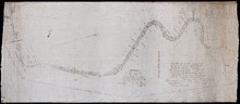
Paln No. 1 of Railway Appropriation: from Alberton to Tignish
Description: Plan of Railway Appropriations from Alberton to Tignish. (Plan No.1). The map shows roads, resdients, acreage, lots, and foliage.
Province: Prince Edward Island
Type: cadastral maps
Date Created: 1873
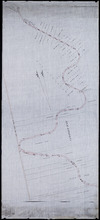
Plan No. 2 of Railway Appopriation: From Alberton to Tignish
Description: Plan of Railway Appropriations from Alberton to Tignish. (Plan No.2). The map shows roads, lots, residents, acreage, and foliage.
Province: Prince Edward Island
Type: cadastral maps
Date Created: 1873
Plan of part of the Railway appropriations in Lot 45: Harmony Station
Description: Plan of part of the Railway appropriations in Lot 45. Harmony Station. The map shows roads, residents and acreage.
Province: Prince Edward Island
Type: cadastral maps
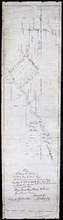
Plan showing the position of 2 new lines of road from R. McMillan's Mills to Fredericton…
Description: Plan showing the position of 2 new lines of road from R. McMillan's Mills to Fredericton Station. Also through McMillan's land from French Settlement. Also from Trout River Bridge to Road… more
Province: Prince Edward Island
Type: cadastral maps