Displaying 406 - 432 of 504
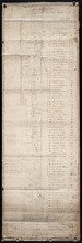
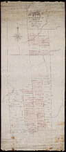
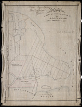
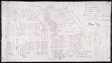
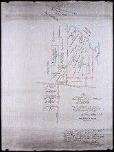
Plan of Lot or Township No. 66: from the latest Surveys by Jos. Ball Surveyor General's Office…
Description: Plan of Lot 66. Gives list of settlers. The map shows Lot 66 divided into numbered parcels of land. Along the side there is a corresponding list of parcel numbers and settlers' names handwritten… more
Province: Prince Edward Island
Type: cadastral maps
Date Created: 1856-08-04
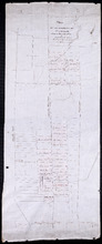
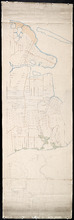
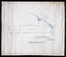
Plan of Lot or Township No. 66 from actual survey.
Description: Plan of Lot or Township No. 66 from actual survey. Rolled paper on fabric backing; handwriting on verso. The map shows Lot 66 divided into parcels of land with the names of residents and their… more
Province: Prince Edward Island
Type: cadastral maps
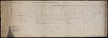
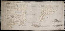
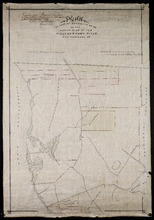
Plan of the Moiety of Lot or Township No 29 of the Estate of Viscount elville situated in Prince…
Description: Plan of the east moiety of Lot 29 (No.2). Part of the estate of Lord Viscount Melville. The map shows lots, residents, roads, and bodies of water such as rivers.
Province: Prince Edward Island
Type: cadastral maps
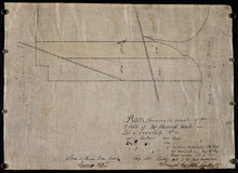
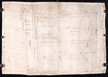
Plan Showing the situation of the Estate of Mr. Clement White on Lot or Township No. 32
Description: Plan of part of Lot 32 (No.21). The estate of Mr. Clement White. The map shows lots, residents, roads, and York (or North) River.
Province: Prince Edward Island
Type: cadastral maps
Date Created: 1874-01
Plan of the Property of Mrs Smith situate in Township No 33 in Prince Edward Island: Mrs S's…
Description: Plan of part of Lot 33 showing the property of Mrs. S.W. Smith. The map shows lots, residents, acreage, roads, and water.
Province: Prince Edward Island
Type: cadastral maps
Plan of the Property of Ms S W Smith Situate on Township No 33 in Prince Edward Island: Mrs S'…
Description: Plan of part of Lot 33, showing the property of Mrs. S.W. Smith. The map shows lots, residents, roads, and bodies of water such as rivers.
Province: Prince Edward Island
Type: cadastral maps
Plan of Lot 35
Description: Plan of Lot 35 (No.95). Shows some residents, lots, roads, bodies of water and foliage.
Province: Prince Edward Island
Type: cadastral maps
Part of Lot 35 in Queens county
Description: Plan of part of Lot 35 (No.631). The Estate of John A. MacDonald. Shows area around Johnston's River. Date of plan: post 1811, after the death of Captain MacDonald. The map shows lots, residents… more
Province: Prince Edward Island
Type: cadastral maps
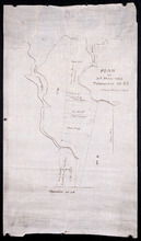
Plan of part of Township Number 35 situate on the North side of the Hillsborough River.: Those…
Description: Plan of Lot 35 (No.1). North side of the Hillsborough River. Property of Rev. John MacDonald. From a tracing by W.C. Harris. The map shows lots, residents, roads, and bodies of water.
Province: Prince Edward Island
Type: cadastral maps
Date Created: 1878-03-21
Plan of Part of Township no 35 on Bedford Bay
Description: Plan of part of Lot 35 (No.631) bordering on Bedford Bay. The map shows lots, residents, roads, and various bodies of water.
Province: Prince Edward Island
Type: cadastral maps
Plan of Part of Township No. 35 on the North Side of the Hillsborough River
Description: Plan of part of Lot 35 on the north side of the Hillsborough River. The map shows lots, residents, roads, Bedford Bay and foliage.
Province: Prince Edward Island
Type: cadastral maps
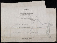
Plan of Part of Township No. 35 situate on the South Side of the Hillsborough River
Description: Plan of part of Lot 35 situate on the south side of the Hillsborough River. The property of John Apollinarius MacDonnell. Plan copied by R.T. Weeks. The map shows lots, residents, roads, islands, and… more
Province: Prince Edward Island
Type: cadastral maps
Plan of St Martins Township No 35
Description: Plan of part of Lot 35, St. Martins. The map shows lots, residents, and bodies of water such as rivers.
Province: Prince Edward Island
Type: cadastral maps
Plan if the Southren Moiety of Township No 36 Part of the Estate of the Rev: John Alister Somerlet…
Description: Plan of the southern moiety of Lot 36 (No.2). Part of the estate of the Rev. John Alister Somerlet MacDonald. From a tracing by W.C. Harris. The map shows lots, residents, a pond, and roads.
Province: Prince Edward Island
Type: cadastral maps
Date Created: 1878-03-22
Plan of Lot 37
Description: Plan of Lot 37, north of the Hillsborough River. Shows some residents, lots, roads, and bodies of water.
Province: Prince Edward Island
Type: cadastral maps
Surveyor General's Plan for south western half of Lot 37
Description: Surveyor General's Plan for south western half of Lot 37 (No.1). The map shows lots, residents, and bodies of water. more
Province: Prince Edward Island
Type: cadastral maps
Plan of part of Lot 38
Description: Plan of part of Lot 38 (No.7). Part of Mrs. Burns' property, sold to LeLacheur and others. The map shows lots, and residents. more
Province: Prince Edward Island
Type: cadastral maps
Plan of the estates of the late Angus McDonald and James McDonald at Springfield Township No 39:…
Description: Part of Lot 39. Plan of the estates of the late Angus McDonald and James McDonald at Springfield. Also the subdivisions of the same as agreed upon at the time of survey. The map shows lots, residents… more
Province: Prince Edward Island
Type: cadastral maps
Date Created: 1910-09
Plan of the division line between Lots 48 and 49
Description: Plan of the division line between Lots 48 and 49. The map shows lots, residents, roads, and bodies of water.
Province: Prince Edward Island
Type: cadastral maps
Date Created: 1841-06
Plan of the division line between Lots 31 and 65, the commencement of which was set by the…
Description: Plan of the division line between Lots 31 and 65, the commencement of which was set by the Commissioners for establishing boundary lines. (No.1) The map shows lots, roads, and rivers.
Province: Prince Edward Island
Type: cadastral maps
Date Created: 1837-08-26
Royalty of Charlotettown
Description: Plan showing the line dividing Lots 33 and 34. (No.10). The map shows lots, residents, roads, and bodies of water.
Province: Prince Edward Island
Type: cadastral maps
Plan showing the point of commencement of the division line between Lots 48 and 49, established by…
Description: Plan showing the point of commencement of the division line between Lots 48 and 49, established by the Commissioners under the Boundary Bill, July 30, 1840. The map shows lots, residents, roads,… more
Province: Prince Edward Island
Type: cadastral maps
Date Created: 1840-08
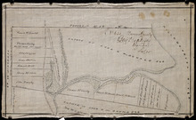
Plan of a New Road from the Flat River Road (marked A, B, C, D, E, F.) to the shore of the straits…
Description: Plan of a New Road from the Flat River Road to the shore of the straits. On Lots 60 and 62. The map shows lots, residents, roads, and water.
Province: Prince Edward Island
Type: cadastral maps
Plan shewing the situation of a new line of road from Baldwin's Road, Lot 51 to Brother's…
Description: Plan showing the situation of a new line of road from Baldwin's Road, Lot 51 to Brother's Road, Lot 66 more
Province: Prince Edward Island
Type: cadastral maps
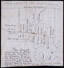
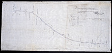
Plan shewing the situation of the line of road leading from Cherry Valley to the contemplated…
Description: Plan showing the situation of the line of road leading from Cherry Valley to the contemplated bridge on Seal River and the 24 chains and 50 links unopened line of road along the line between the… more
Province: Prince Edward Island
Type: cadastral maps
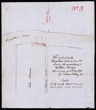
Plan of part of the Georgetown Road on Lot 51 showing the encrouchment by John Curran from a survey…
Description: Plan of part of the Georgetown Road on Lot 51. Shows Union Road and property of John Curran. (No.3) The map shows lots, resident, and roads.
Province: Prince Edward Island
Type: cadastral maps
Date Created: 1908-06-04
Plan of the road from Kelly's Cove to the line between John F. Baker and Frank Bovyer thro…
Description: Plan of the road from Kelly's Cove to the line between John F. Baker and Frank Bovyer through Bunbury, Lot 48. Ordered to be widened. The map shows lots, residents, roads, and water. more
Province: Prince Edward Island
Type: cadastral maps