Displaying 352 - 378 of 504
Plan of part of Lot 28, showing the property of William Carruthers bordering on Borden Harbour.
Description: Plan of part of Lot 28, showing the property of William Carruthers bordering on Borden Harbour. The map shows lots, residents, water, and roads.
Province: Prince Edward Island
Type: cadastral maps

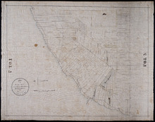
Plan of Town Lots No.74 and No.75 in the 4th Hundred of Town Lots in the city of Charlottetown with…
Description: Plan of Town Lots No.74 and No.75 in the 4th Hundred of Town Lots in the city of Charlottetown with the respective subdivisions delineated thereon. (No.64) Shown are lots and residents.
Province: Prince Edward Island
Type: cadastral maps

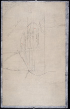
Plan of Lot 5: Mainly Outline
Description: Plan of Lot 5. Mainly outline. Shows names of some residents east of Mill River, lots, and waters.
Province: Prince Edward Island
Type: cadastral maps
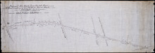
Plan of New Line Road From Montague Bridge tp Keith's Mill on Lots No. 51 & 52: Kings…
Description: Plan of a new line of road from Montague Bridge to Keith's Mill on Lots 51 and 52. As ordered by Jas. E. McDonald, late C.P.W. The map shows lots, residents, roads, and bodies of water such as… more
Province: Prince Edward Island
Type: cadastral maps
Copy of a plan made by Alexander Anderson in 1845 of that portion of the northern part of Lot 11…
Description: Copy of a plan made by Alexander Anderson in 1845 of that portion of the northern part of Lot 11 sold at various times for land taxes. Plan shows property bought by David Ramsay at a Sheriff's… more
Province: Prince Edward Island
Type: cadastral maps
Date Created: 1909
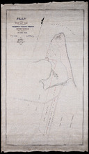
Plan of Shore and Land connected with The Beach Fishery Station Murray Harbour: The Property of Hon…
Description: Plan of part of Lot 64. The shore and land connected with the Beach Fishery Station, Murray Harbour. The property of the Hon. David Davies. The map shows lots, residents, bodies of water, and roads.
Province: Prince Edward Island
Type: cadastral maps
Date Created: 1872-10-29
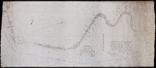
A Plan of Souris Beach
Description: Plan of part of Lots 44 and 45, Souris Beach. The map shows dry spots at low water, lots, and residents.
Province: Prince Edward Island
Type: cadastral maps
Date Created: 1866
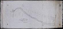
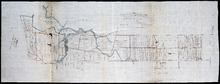
P.E.I. Railway Murray Harbour Branch: Plan of Spur Line and Ballast Pit at Surrey
Description: Prince Edward Island Railway. Murray Harbour Branch. Plan of Spur Line and Ballast Pit at Surrey (No.1159). Plan produced by H. Laurence, Engineer in Charge. Shown are roads, the railway, lots, and… more
Province: Prince Edward Island
Type: cadastral maps
Date Created: 1908-12-02
Sketch of parts of Lots 4 and 5
Description: Sketch of parts of Lots 4 and 5. Area along Mill River(?). Shown are lots, and water.
Province: Prince Edward Island
Type: cadastral maps
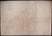
Plan of Township No. 7 the property of R.Bruce Stewart: Drawn by R. Stewart 1861 from survey by A.…
Description: Plan of Lot 7. The property of R. Bruce Stewart (No.23). Surveyed by A. Anderson and others, and drawn by R. Stewart. The map shows lots, residents, and roads.
Province: Prince Edward Island
Type: cadastral maps
Date Created: 1861

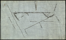
Plan of marsh lands on the two sides of the Pisquid River
Description: Plan of marsh lands on the two sides of the Pisquid River. Lot 37. (No.68, Queens Co.) The map shows lots, residents, measurements, and acerage.
Province: Prince Edward Island
Type: cadastral maps
Date Created: 1897-12

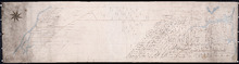
Plan of Lot 31
Description: Plan of Lot 31 (No.2). Mainly outline. Shows Refugee Share drawn for in Council, 12 February, 1784. Signed by John Russell Spence, Clerk of the Council.
Province: Prince Edward Island
Type: cadastral maps
Date Created: 1784
Plan of Township No. 7: Copied from the the Survey of John Clan L.S>
Description: Plan of Lot 7 (No.22). Stewart Estate. Shows names of residents, acreage, and references to land conveyance, roads, and bodies of water. Plan copied by Owen Curtis.
Province: Prince Edward Island
Type: cadastral maps
Tracing of Plan of the North Moiety of Township No. 26: The property of the Messrs Thompson of…
Description: Tracing of Plan of the North Moiety of Lot 26, the property of the Messrs. Thompson of Belfast, Ireland. Documents attached. The map shows lots, residents, roads, acreage, and bodies of water.
Province: Prince Edward Island
Type: cadastral maps
Date Created: 1875-11-05
Proposed New Road from Chapel Road: To Road leading to Grand River Beach Road
Description: Plan of proposed New Road from Chapel Road to road leading to Grand River Beach Road. Total distance 2.16 miles. (No.47) The map shows residents, lots, roads, and foliage.
Province: Prince Edward Island
Type: cadastral maps

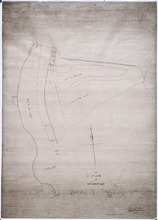
Plan of Part of Railway Line on Lot No. 16
Description: Plan of part of the Railway Line on Lot 16. The map shows roads, lots, water, and residents.
Province: Prince Edward Island
Type: cadastral maps
Date Created: 1872-04-30

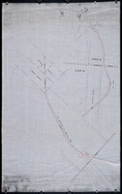
Prince Edward Island Railway Plan showing right of way of the Murray Harbour Branch through Queen…
Description: Prince Edward Island Railway Plan showing right of way of the Murray Harbour Branch through Queen's County from Village Green to Pisquid Road. (Plan No.6) The map shows lots, residents, railway… more
Province: Prince Edward Island
Type: cadastral maps
Plan of part of the Railway appropriation in Lots 5 and 6
Description: Plan of part of the Railway appropriation in Lots 5 and 6. Shown are lots, roads, and residents.
Province: Prince Edward Island
Type: cadastral maps, transportation maps
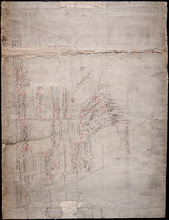
Plan of Lot 2
Description: The map shows Lot 2 divided into parcels of land. It provides the names of residents, their acreage amounts and some land conveyance references for most of the east end of the lot and for a small… more
Province: Prince Edward Island
Type: cadastral maps
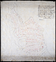
Plan of Lot 47
Description: Plan of Lot 47 (No. 127). Stewart and Cunard Estates. The map shows Lot 47 divided into parcels of land with the names of residents, acreage amounts and land conveyance references. Some areas of the… more
Province: Prince Edward Island
Type: cadastral maps

Plan of Lot 48
Description: Plan of Lot 48. Incomplete. Shows names of residents, acreage, and some land conveyance references for the eastern part of the lot, roads and bodies of water.
Province: Prince Edward Island
Type: cadastral maps
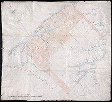
Plan of Lots 38, 39, 40, 41, 42, 66 and part of Lot 43
Description: The map shows some of the lots and parishes in a northern portion of Kings County. It shows Savage Harbour, St. Peter's Bay, rivers, streams, mills, roads, buildings and churches. The map has a… more
Province: Prince Edward Island
Type: topographic maps
Part of Lot 38
Description: The map, drawn in pencil, shows four numbered parcels of land on or near Savage Harbour in the northern portion of Lot 38. It includes names of residents and land conveyance references. At least… more
Province: Prince Edward Island
Type: cadastral maps
This Plan shewing the lands appropriated by the Railway Commisioners is filed with the Office of…
Description: Prince Edward Island Railway. Plan shows land appropriated by the Railway Commissioners on Lot 45. (No.235C). The map shows residents, acreage, roads, and a church.
Province: Prince Edward Island
Type: cadastral maps

Plan of Prince Edward Island showing the names of the Proprietors
Description: Plan of Prince Edward Island showing the names of the Proprietors, their acreage, and the number of settlers on their property. The map shows Prince Edward Island divided into the 67 lots established… more
Province: Prince Edward Island
Type: topographic maps

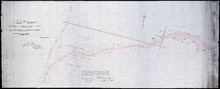
Plan of Part of the Railway Line on Lots No. 16 and 17
Description: Plan of part of the Railway Line on Lots 16 and 17. Appropriations from Lot 16 to the French purchase. The map shows roads, lots, residents, and acreage.
Province: Prince Edward Island
Type: cadastral maps
Date Created: 1872-04-29

Plan of Part of the Railway Line on Lot No. 17: Shewing the Stations Grounds at Summerside.
Description: Plan of part of the Railway Line on Lot 17 showing the Station Grounds at Summerside (No.2). Former location of the appropriations from Linkletter Road into Summerside. The map shows roads, lots,… more
Province: Prince Edward Island
Type: cadastral maps
Date Created: 1872-04-29