Displaying 1 - 2 of 2

Plan of Lot Thirty Seven: Queens Co., P.E.I.
Description: Map of Lot 37 and part of Lot 38. Map is from Meacham's 1880 PEI Historical Atlas. A few land conveyance references have been added in red ink. The map shows bodies of water such as rivers,… more
Province: Prince Edward Island
Type: cadastral maps
Date Created: 1880
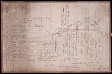
Plan of the western part of Lot 16
Description: Plan of the western part of Lot 16. Shows names of residents, acreage, and a few land conveyance references. The map shows bodies of water, roads, other lots such as 15, and 18 in Indian River, a… more
Province: Prince Edward Island
Type: cadastral maps
Date Created: 1880-01-24